


<< Our Photo Pages >> Kroatenhügel - Chambered Tomb in Germany in Saxony-Anhalt
Submitted by Klingon on Thursday, 14 April 2022 Page Views: 652
Neolithic and Bronze AgeSite Name: KroatenhügelCountry: Germany
NOTE: This site is 3.72 km away from the location you searched for.
Land: Saxony-Anhalt Type: Chambered Tomb
Nearest Town: Magdeburg
Latitude: 52.109120N Longitude: 11.586246E
Condition:
| 5 | Perfect |
| 4 | Almost Perfect |
| 3 | Reasonable but with some damage |
| 2 | Ruined but still recognisable as an ancient site |
| 1 | Pretty much destroyed, possibly visible as crop marks |
| 0 | No data. |
| -1 | Completely destroyed |
| 5 | Superb |
| 4 | Good |
| 3 | Ordinary |
| 2 | Not Good |
| 1 | Awful |
| 0 | No data. |
| 5 | Can be driven to, probably with disabled access |
| 4 | Short walk on a footpath |
| 3 | Requiring a bit more of a walk |
| 2 | A long walk |
| 1 | In the middle of nowhere, a nightmare to find |
| 0 | No data. |
| 5 | co-ordinates taken by GPS or official recorded co-ordinates |
| 4 | co-ordinates scaled from a detailed map |
| 3 | co-ordinates scaled from a bad map |
| 2 | co-ordinates of the nearest village |
| 1 | co-ordinates of the nearest town |
| 0 | no data |
Internal Links:
External Links:
I have visited· I would like to visit
Klingon visited on 13th Apr 2022 - their rating: Cond: 2 Amb: 3 Access: 5
")
The remains of a large tomb, now there are two groups of big stones here.
You may be viewing yesterday's version of this page. To see the most up to date information please register for a free account.
")
Do not use the above information on other web sites or publications without permission of the contributor.
Nearby Images from Flickr
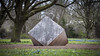
The above images may not be of the site on this page, but were taken nearby. They are loaded from Flickr so please click on them for image credits.
Click here to see more info for this site
Nearby sites
Click here to view sites on an interactive map of the areaKey: Red: member's photo, Blue: 3rd party photo, Yellow: other image, Green: no photo - please go there and take one, Grey: site destroyed
Download sites to:
KML (Google Earth)
GPX (GPS waypoints)
CSV (Garmin/Navman)
CSV (Excel)
To unlock full downloads you need to sign up as a Contributory Member. Otherwise downloads are limited to 50 sites.
Turn off the page maps and other distractions
Nearby sites listing. In the following links * = Image available
3.9km WSW 245° Hängelsberge* Chambered Tomb
5.6km NNE 12° Kleiner Silberberg* Burial Chamber or Dolmen
6.4km NNE 13° Grosser Silberberg* Burial Chamber or Dolmen
8.5km NNE 14° Pfahlberg* Burial Chamber or Dolmen
15.6km ENE 59° Körbelitz Steinkreuze* Ancient Cross
15.8km ENE 64° Koerbelitz Steingrab* Chambered Tomb
17.9km SE 130° Kreisgrabenanlage Schönebeck* Henge
19.2km SE 130° Pömmelte Kultstätte* Timber Circle
19.9km NW 320° Hundisburg Schalenstein Rock Art
20.4km NW 321° Hundisburg 15* Burial Chamber or Dolmen
20.4km NW 321° Hundisburg 123 Chambered Tomb
20.6km NW 321° Hundisburg 27 Chambered Tomb
20.7km NW 321° Hundisburg 26 Chambered Tomb
20.7km NW 319° Galgenberg Huegelgrabfeld* Barrow Cemetery
20.8km NW 318° Hundisburg 29 Chambered Tomb
20.9km NW 325° Althaldensleben 34 Chambered Tomb
21.0km NW 317° Hundisburg 28 Chambered Tomb
21.0km NW 324° Althaldensleben 32 Chambered Tomb
21.1km NW 324° Althaldensleben 33 Chambered Tomb
21.1km NW 324° Althaldensleben 31 Chambered Tomb
21.4km NW 323° Hundisburg 25 Chambered Tomb
21.5km W 268° Götterstein* Standing Stone (Menhir)
21.6km NW 317° Dönstedt 18 Chambered Tomb
21.7km NNW 329° Althaldensleben 30 Chambered Tomb
21.7km NW 317° Dönstedt 17 Chambered Tomb
View more nearby sites and additional images


 We would like to know more about this location. Please feel free to add a brief description and any relevant information in your own language.
 Wir möchten mehr über diese Stätte erfahren. Bitte zögern Sie nicht, eine kurze Beschreibung und relevante Informationen in Deutsch hinzuzufügen.
 Nous aimerions en savoir encore un peu sur les lieux. S'il vous plaît n'hesitez pas à ajouter une courte description et tous les renseignements pertinents dans votre propre langue.
 Quisieramos informarnos un poco más de las lugares. No dude en añadir una breve descripción y otros datos relevantes en su propio idioma.