


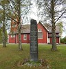
<< Our Photo Pages >> Mørhaugen - Round Barrow(s) in Norway in Hedmark
Submitted by kenntha88 on Tuesday, 28 September 2021 Page Views: 336
Iron Age and Later PrehistorySite Name: MørhaugenCountry: Norway
NOTE: This site is 58.042 km away from the location you searched for.
Fylke: Hedmark Type: Round Barrow(s)
Nearest Town: Hamar
Latitude: 60.852316N Longitude: 11.247398E
Condition:
| 5 | Perfect |
| 4 | Almost Perfect |
| 3 | Reasonable but with some damage |
| 2 | Ruined but still recognisable as an ancient site |
| 1 | Pretty much destroyed, possibly visible as crop marks |
| 0 | No data. |
| -1 | Completely destroyed |
| 5 | Superb |
| 4 | Good |
| 3 | Ordinary |
| 2 | Not Good |
| 1 | Awful |
| 0 | No data. |
| 5 | Can be driven to, probably with disabled access |
| 4 | Short walk on a footpath |
| 3 | Requiring a bit more of a walk |
| 2 | A long walk |
| 1 | In the middle of nowhere, a nightmare to find |
| 0 | No data. |
| 5 | co-ordinates taken by GPS or official recorded co-ordinates |
| 4 | co-ordinates scaled from a detailed map |
| 3 | co-ordinates scaled from a bad map |
| 2 | co-ordinates of the nearest village |
| 1 | co-ordinates of the nearest town |
| 0 | no data |
Internal Links:
External Links:
")
The barrow is around 50 metres in diameter and around 8 metres in height. This would be one of the largest barrows in the Hedmark area! It is overgrown with large trees and smaller brush and appear mostly like a "island" in the grain field but it is visible from far away.
You may be viewing yesterday's version of this page. To see the most up to date information please register for a free account.
")
Do not use the above information on other web sites or publications without permission of the contributor.
Nearby Images from Flickr


The above images may not be of the site on this page, but were taken nearby. They are loaded from Flickr so please click on them for image credits.
Click here to see more info for this site
Nearby sites
Click here to view sites on an interactive map of the areaKey: Red: member's photo, Blue: 3rd party photo, Yellow: other image, Green: no photo - please go there and take one, Grey: site destroyed
Download sites to:
KML (Google Earth)
GPX (GPS waypoints)
CSV (Garmin/Navman)
CSV (Excel)
To unlock full downloads you need to sign up as a Contributory Member. Otherwise downloads are limited to 50 sites.
Turn off the page maps and other distractions
Nearby sites listing. In the following links * = Image available
1.4km SSW 203° Liberg Cairn* Cairn
3.5km SE 125° Doksrud Hillfort* Hillfort
4.3km SSW 206° Ingvoldstad Store* Round Barrow(s)
4.6km SE 133° Norderhov-Østre* Cairn
4.7km WSW 237° Heggenhaugen* Round Barrow(s)
4.7km SSW 208° Hommelstadvegen* Round Barrow(s)
4.8km ESE 122° Skrinhagan* Round Barrow(s)
5.2km SW 216° Grindbakken* Round Barrow(s)
5.2km SW 221° Helstad* Round Barrow(s)
5.2km SSW 209° Forsøksgård-Dørum* Cairn
5.2km SSW 208° Dørumvegen* Round Barrow(s)
5.4km SSW 210° Sør-Dørum* Barrow Cemetery
5.5km SE 129° Veen* Stone Circle
5.9km SW 236° Midtvangvegen* Round Barrow(s)
6.1km SW 235° Skraastad Nedre* Round Barrow(s)
6.3km SSE 167° Haukstad* Round Barrow(s)
6.3km SW 221° Kraftrud-Halvdanshaugen* Round Barrow(s)
6.4km ESE 111° Kongstadjordet* Cairn
6.4km SE 130° Skøyen* Round Barrow(s)
6.5km SE 127° Løten Kommunehus* Round Barrow(s)
6.6km SW 217° Olsrud* Round Barrow(s)
6.6km SE 132° Snipphaugen* Round Barrow(s)
6.6km ESE 123° Løten Prestegård* Barrow Cemetery
6.6km SE 142° Finstad-Store* Cairn
6.6km SSE 158° Ådalsbruk-Løken Store* Barrow Cemetery
View more nearby sites and additional images


 We would like to know more about this location. Please feel free to add a brief description and any relevant information in your own language.
 Wir möchten mehr über diese Stätte erfahren. Bitte zögern Sie nicht, eine kurze Beschreibung und relevante Informationen in Deutsch hinzuzufügen.
 Nous aimerions en savoir encore un peu sur les lieux. S'il vous plaît n'hesitez pas à ajouter une courte description et tous les renseignements pertinents dans votre propre langue.
 Quisieramos informarnos un poco más de las lugares. No dude en añadir una breve descripción y otros datos relevantes en su propio idioma.