


<< Our Photo Pages >> Via Cava di Poggio Prisca - Ancient Trackway in Italy in Toscana
Submitted by ivanjohnson on Tuesday, 10 August 2010 Page Views: 5602
Roman, Greek and ClassicalSite Name: Via Cava di Poggio PriscaCountry: Italy
NOTE: This site is 26.288 km away from the location you searched for.
Region: Toscana Type: Ancient Trackway
Nearest Town: Sovana Nearest Village: Sovana
Latitude: 42.658719N Longitude: 11.633783E
Condition:
| 5 | Perfect |
| 4 | Almost Perfect |
| 3 | Reasonable but with some damage |
| 2 | Ruined but still recognisable as an ancient site |
| 1 | Pretty much destroyed, possibly visible as crop marks |
| 0 | No data. |
| -1 | Completely destroyed |
| 5 | Superb |
| 4 | Good |
| 3 | Ordinary |
| 2 | Not Good |
| 1 | Awful |
| 0 | No data. |
| 5 | Can be driven to, probably with disabled access |
| 4 | Short walk on a footpath |
| 3 | Requiring a bit more of a walk |
| 2 | A long walk |
| 1 | In the middle of nowhere, a nightmare to find |
| 0 | No data. |
| 5 | co-ordinates taken by GPS or official recorded co-ordinates |
| 4 | co-ordinates scaled from a detailed map |
| 3 | co-ordinates scaled from a bad map |
| 2 | co-ordinates of the nearest village |
| 1 | co-ordinates of the nearest town |
| 0 | no data |
Internal Links:
External Links:
")
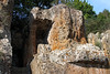
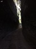
Via cava (excavated or quarried roads) are ancient Tuscan (and perhaps elsewhere) roads cut as slot shafts into solid rock, which apparently provided a reasonably sloped roadway to transport things up and down the Tuscan cliffs. Possibly built as early as the iron age, they may also have had a defensive function - one can readily see that it would be easy to drop boulders or boiling oil down on unwanted intruders. Some via cava are quite spectacular - check the page on Via cava di S. Sebastiano.
This one, Via cava di Poggio Prisca, is located next to the wonderful Ildebranda Tomb (see its separate page) inside the Sovana Necropolis archaeological park directly below the town of Sovana, Toscana.
The via cava in general are very interesting unique road constructions.
You may be viewing yesterday's version of this page. To see the most up to date information please register for a free account.
")
")
")
Do not use the above information on other web sites or publications without permission of the contributor.
Nearby Images from Flickr
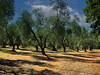
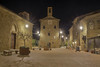
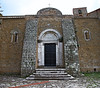
The above images may not be of the site on this page, but were taken nearby. They are loaded from Flickr so please click on them for image credits.
Click here to see more info for this site
Nearby sites
Click here to view sites on an interactive map of the areaKey: Red: member's photo, Blue: 3rd party photo, Yellow: other image, Green: no photo - please go there and take one, Grey: site destroyed
Download sites to:
KML (Google Earth)
GPX (GPS waypoints)
CSV (Garmin/Navman)
CSV (Excel)
To unlock full downloads you need to sign up as a Contributory Member. Otherwise downloads are limited to 50 sites.
Turn off the page maps and other distractions
Nearby sites listing. In the following links * = Image available
40m SW 219° Ildebranda Tomb* Rock Cut Tomb
495m SSE 147° Via cava di S. Sebastiano* Ancient Trackway
682m SE 135° Tomba della Sirena* Rock Cut Tomb
1.5km E 96° Sovana Necropolis* Rock Cut Tomb
10.0km ENE 75° Vitozza* Cave or Rock Shelter
29.9km SSE 158° San Giulano Rock Cut tombs Rock Cut Tomb
39.2km E 80° Necropoli del Crocifisso del Tufo Rock Cut Tomb
39.4km SW 226° Cosa.* Hillfort
41.6km NNE 28° Civic Archaeological Museum* Museum
42.9km WNW 296° Roselle* Hillfort
43.9km SE 144° Norchia Etruscan Necropolis* Rock Cut Tomb
46.5km SSE 163° Tarquinia* Ancient Village or Settlement
51.9km SE 143° Pian di Vescovo Rock Cut Tomb
54.0km ESE 121° Mount Cimino Votive Site* Ancient Temple
55.1km ESE 111° Bomarzo Etruscan 'Pyramid' Altar* Ancient Temple
56.9km SSE 148° Casale Vignale Necropolis Chambered Cairn
57.4km SE 140° Barbarano Romano Etruscan Necropolis Chambered Tomb
57.5km WNW 295° Tomba del Diavolino 2* Chambered Cairn
57.7km SSE 147° Civitella Cesi Etruscan Tomb* Rock Cut Tomb
58.4km WNW 293° Vetulonia Mura dell' Arce* Ancient Village or Settlement
59.3km NNW 340° Poggio Civitate Ancient Village or Settlement
67.5km SE 133° Sutri Necropolis* Rock Cut Tomb
67.6km SE 133° Sutri amphitheatre* Ancient Village or Settlement
75.7km E 91° Carsulae Ancient Village or Settlement
79.5km NE 51° The Hypogeum of the Volumni* Rock Cut Tomb
View more nearby sites and additional images


 We would like to know more about this location. Please feel free to add a brief description and any relevant information in your own language.
 Wir möchten mehr über diese Stätte erfahren. Bitte zögern Sie nicht, eine kurze Beschreibung und relevante Informationen in Deutsch hinzuzufügen.
 Nous aimerions en savoir encore un peu sur les lieux. S'il vous plaît n'hesitez pas à ajouter une courte description et tous les renseignements pertinents dans votre propre langue.
 Quisieramos informarnos un poco más de las lugares. No dude en añadir una breve descripción y otros datos relevantes en su propio idioma.