


<< Our Photo Pages >> Ildebranda Tomb - Rock Cut Tomb in Italy in Toscana
Submitted by ivanjohnson on Saturday, 07 August 2010 Page Views: 4636
Multi-periodSite Name: Ildebranda TombCountry: Italy
NOTE: This site is 10.61 km away from the location you searched for.
Region: Toscana Type: Rock Cut Tomb
Nearest Town: Sovana Nearest Village: Sovana
Latitude: 42.658441N Longitude: 11.633474E
Condition:
| 5 | Perfect |
| 4 | Almost Perfect |
| 3 | Reasonable but with some damage |
| 2 | Ruined but still recognisable as an ancient site |
| 1 | Pretty much destroyed, possibly visible as crop marks |
| 0 | No data. |
| -1 | Completely destroyed |
| 5 | Superb |
| 4 | Good |
| 3 | Ordinary |
| 2 | Not Good |
| 1 | Awful |
| 0 | No data. |
| 5 | Can be driven to, probably with disabled access |
| 4 | Short walk on a footpath |
| 3 | Requiring a bit more of a walk |
| 2 | A long walk |
| 1 | In the middle of nowhere, a nightmare to find |
| 0 | No data. |
| 5 | co-ordinates taken by GPS or official recorded co-ordinates |
| 4 | co-ordinates scaled from a detailed map |
| 3 | co-ordinates scaled from a bad map |
| 2 | co-ordinates of the nearest village |
| 1 | co-ordinates of the nearest town |
| 0 | no data |
Internal Links:
External Links:
")
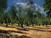
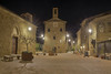
The area for several miles around this site is absolutely a megalithic goldmine packed with rock-cut Etruscan necropoli, spectacular rock-cut ancient roads (via cava), relatively elaborate and fascinating troglodyte rock-cut cave towns, all in a very wild spectacular setting.
Ildebranda Tomb is one of the highlights of this fascinating area.
from the Experience Tuscany website:
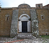
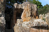
"Ildebranda Tomb was discovered in 1924 by one of the Rosi brothers, and then carefully studied in detail by Ranuccio Bianchi-Bandinelli. It dates back to the Third or Second century BC and is considered the most important monument of the necropolis and the whole Etruria. Not knowing anything about the person that had built such an imposing and “bizarre” grave, the discoverers wanted to give it the name of the most illustrious citizen of Sovana, the former pope Ildebrando.
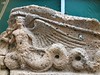
The tomb is composed of two distinct parts: the burial chamber, and the burial monument, both cut into the tuff walls not far from the center of Sovana. The monument was built without adding external materials. Precisely for this reason, due to the brittleness of tufa, many of its architectural elements have been lost. Through decorative fragments recovered during the excavations, and thanks to comparisons with the pediment of the Temple of Talomone, a fairly realistic reconstruction of the tomb could be done. Thanks to this reconstruction it is possible to state that the Ildebranda tomb was built in the style of a Greek temple. Features and architectural and decorative elements underline the socio-cultural relations between ancient Greece and the Etruscans.
The monument included a high podium with two side stairways where there were 12 columns marking a “pronaos” with coffered ceiling. On the columns rested the “crowning” which was the most ornamental part thanks to the frieze on three sides decorated with a series of griffins and human figures and plant motifs. The whole monument was covered with polychrome stuccos, as the decorative Etruscan art loved bright colours. Unfortunately, today very little is left of the tomb’s original appearance, although its appeal is still considerable.
The burial chamber, located symmetrically beneath the monument, has no decorations and no burial paraphernalia, as it was desecrated in ancient times. It is accessible through a central “dromos” that goes down for about ten meters. This “dromos” intersects another one on the right that descends for about 10 meters to reach a tomb from the Fourth century BC. The burial chamber of the latter is Greek style, and its coffered ceiling shows fine workmanship. The tomb Ildebranda is situated in a dominant position within walking distance from the road of the Etruscan “Cavone” road. It was not only a great architectural work but probably was also used as a sacred place and certainly represented a landmark for travellers passing by the territory of Sovana."
You may be viewing yesterday's version of this page. To see the most up to date information please register for a free account.
")
")
")
")
Do not use the above information on other web sites or publications without permission of the contributor.
Nearby Images from Flickr
The above images may not be of the site on this page, but were taken nearby. They are loaded from Flickr so please click on them for image credits.
Click here to see more info for this site
Nearby sites
Click here to view sites on an interactive map of the areaKey: Red: member's photo, Blue: 3rd party photo, Yellow: other image, Green: no photo - please go there and take one, Grey: site destroyed
Download sites to:
KML (Google Earth)
GPX (GPS waypoints)
CSV (Garmin/Navman)
CSV (Excel)
To unlock full downloads you need to sign up as a Contributory Member. Otherwise downloads are limited to 50 sites.
Turn off the page maps and other distractions
Nearby sites listing. In the following links * = Image available
40m NE 39° Via Cava di Poggio Prisca* Ancient Trackway
485m SE 143° Via cava di S. Sebastiano* Ancient Trackway
679m SE 132° Tomba della Sirena* Rock Cut Tomb
1.5km E 95° Sovana Necropolis* Rock Cut Tomb
10.1km ENE 75° Vitozza* Cave or Rock Shelter
29.9km SSE 158° San Giulano Rock Cut tombs Rock Cut Tomb
39.3km E 80° Necropoli del Crocifisso del Tufo Rock Cut Tomb
39.4km SW 226° Cosa.* Hillfort
41.7km NNE 28° Civic Archaeological Museum* Museum
42.9km WNW 297° Roselle* Hillfort
43.9km SE 144° Norchia Etruscan Necropolis* Rock Cut Tomb
46.5km SSE 163° Tarquinia* Ancient Village or Settlement
51.8km SE 143° Pian di Vescovo Rock Cut Tomb
54.0km ESE 121° Mount Cimino Votive Site* Ancient Temple
55.1km ESE 111° Bomarzo Etruscan 'Pyramid' Altar* Ancient Temple
56.9km SSE 148° Casale Vignale Necropolis Chambered Cairn
57.4km SE 140° Barbarano Romano Etruscan Necropolis Chambered Tomb
57.5km WNW 295° Tomba del Diavolino 2* Chambered Cairn
57.7km SSE 147° Civitella Cesi Etruscan Tomb* Rock Cut Tomb
58.3km WNW 293° Vetulonia Mura dell' Arce* Ancient Village or Settlement
59.4km NNW 340° Poggio Civitate Ancient Village or Settlement
67.5km SE 133° Sutri Necropolis* Rock Cut Tomb
67.6km SE 133° Sutri amphitheatre* Ancient Village or Settlement
75.7km E 91° Carsulae Ancient Village or Settlement
79.5km NE 51° The Hypogeum of the Volumni* Rock Cut Tomb
View more nearby sites and additional images


 We would like to know more about this location. Please feel free to add a brief description and any relevant information in your own language.
 Wir möchten mehr über diese Stätte erfahren. Bitte zögern Sie nicht, eine kurze Beschreibung und relevante Informationen in Deutsch hinzuzufügen.
 Nous aimerions en savoir encore un peu sur les lieux. S'il vous plaît n'hesitez pas à ajouter une courte description et tous les renseignements pertinents dans votre propre langue.
 Quisieramos informarnos un poco más de las lugares. No dude en añadir una breve descripción y otros datos relevantes en su propio idioma.