 with our Megalithic Portal iPhone app")

<< Text Pages >> Findling im Himmel - Natural Stone / Erratic / Other Natural Feature in Germany in Saxony-Anhalt
Submitted by KaiHofmann on Tuesday, 20 February 2018 Page Views: 679
Natural PlacesSite Name: Findling im HimmelCountry: Germany
NOTE: This site is 6.972 km away from the location you searched for.
Land: Saxony-Anhalt Type: Natural Stone / Erratic / Other Natural Feature
Nearest Town: Gardelegen Nearest Village: Zichtau
Latitude: 52.621501N Longitude: 11.298550E
Condition:
| 5 | Perfect |
| 4 | Almost Perfect |
| 3 | Reasonable but with some damage |
| 2 | Ruined but still recognisable as an ancient site |
| 1 | Pretty much destroyed, possibly visible as crop marks |
| 0 | No data. |
| -1 | Completely destroyed |
| 5 | Superb |
| 4 | Good |
| 3 | Ordinary |
| 2 | Not Good |
| 1 | Awful |
| 0 | No data. |
| 5 | Can be driven to, probably with disabled access |
| 4 | Short walk on a footpath |
| 3 | Requiring a bit more of a walk |
| 2 | A long walk |
| 1 | In the middle of nowhere, a nightmare to find |
| 0 | No data. |
| 5 | co-ordinates taken by GPS or official recorded co-ordinates |
| 4 | co-ordinates scaled from a detailed map |
| 3 | co-ordinates scaled from a bad map |
| 2 | co-ordinates of the nearest village |
| 1 | co-ordinates of the nearest town |
| 0 | no data |
Internal Links:
External Links:
Natural Stone / Erratic / Other Natural Feature in Saxony-Anhalt
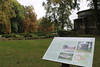
A large boulder which is surrounded by old oaks. Probably an ancient germanic sanctuary.
You may be viewing yesterday's version of this page. To see the most up to date information please register for a free account.
Do not use the above information on other web sites or publications without permission of the contributor.
Nearby Images from Flickr

The above images may not be of the site on this page, but were taken nearby. They are loaded from Flickr so please click on them for image credits.
Click here to see more info for this site
Nearby sites
Click here to view sites on an interactive map of the areaKey: Red: member's photo, Blue: 3rd party photo, Yellow: other image, Green: no photo - please go there and take one, Grey: site destroyed
Download sites to:
KML (Google Earth)
GPX (GPS waypoints)
CSV (Garmin/Navman)
CSV (Excel)
To unlock full downloads you need to sign up as a Contributory Member. Otherwise downloads are limited to 50 sites.
Turn off the page maps and other distractions
Nearby sites listing. In the following links * = Image available
11.3km WNW 282° Nesenitz Steingrab* Chambered Tomb
13.7km NNW 345° Winterfeld Steingrab* Long Barrow
14.6km SE 142° Zienau Kreuz Ancient Cross
14.6km NE 50° Sieben Quellen* Holy Well or Sacred Spring
16.5km NW 304° Butterstein Beetzendorf* Natural Stone / Erratic / Other Natural Feature
16.7km W 275° Immekath Steingrab 2 Chambered Tomb
17.1km W 276° Immekath Steingrab 1* Chambered Tomb
17.2km SSE 152° Menhirgruppe Gardelegen Stone Row / Alignment
17.4km NNE 11° Luege Steingrab* Chambered Tomb
18.9km W 280° Tangeln Steingrab 6* Long Barrow
19.6km WNW 284° Tangeln Steingrab 7* Long Barrow
19.6km NNW 347° Menhiranlage Mahlsdorf* Stone Row / Alignment
19.7km WNW 284° Tangeln Steingrab 1* Long Barrow
19.9km NNE 26° Kerkau Näpfchenstein Rock Art
20.2km W 281° Tangeln Steingrab 4 Chambered Tomb
20.3km W 280° Tangeln Steingrab 5* Chambered Tomb
20.6km W 279° Tangeln Mellin Steingrab Chambered Tomb
22.6km WNW 294° Stoeckheim Steingrab* Passage Grave
22.7km NW 304° Bierstedt Steingrab* Chambered Tomb
22.9km E 82° Beesewege Steingrab* Chambered Tomb
23.7km NW 311° Leetze Steingrab 8* Passage Grave
23.7km NW 311° Leetze Steingrab 7* Passage Grave
23.7km WNW 291° Luedelsen Steingrab 1* Chambered Tomb
23.8km E 80° Buelitz Steingrab* Long Barrow
23.8km WNW 290° Luedelsen Steingrab 5* Chambered Tomb
View more nearby sites and additional images


 We would like to know more about this location. Please feel free to add a brief description and any relevant information in your own language.
 Wir möchten mehr über diese Stätte erfahren. Bitte zögern Sie nicht, eine kurze Beschreibung und relevante Informationen in Deutsch hinzuzufügen.
 Nous aimerions en savoir encore un peu sur les lieux. S'il vous plaît n'hesitez pas à ajouter une courte description et tous les renseignements pertinents dans votre propre langue.
 Quisieramos informarnos un poco más de las lugares. No dude en añadir una breve descripción y otros datos relevantes en su propio idioma.