


<< Our Photo Pages >> Vestgaarden - Cairn in Norway in Nord-Trøndelag
Submitted by kenntha88 on Saturday, 16 October 2021 Page Views: 198
Neolithic and Bronze AgeSite Name: VestgaardenCountry: Norway
NOTE: This site is 9.469 km away from the location you searched for.
Fylke: Nord-Trøndelag Type: Cairn
Nearest Town: Namsos
Latitude: 64.704004N Longitude: 11.434221E
Condition:
| 5 | Perfect |
| 4 | Almost Perfect |
| 3 | Reasonable but with some damage |
| 2 | Ruined but still recognisable as an ancient site |
| 1 | Pretty much destroyed, possibly visible as crop marks |
| 0 | No data. |
| -1 | Completely destroyed |
| 5 | Superb |
| 4 | Good |
| 3 | Ordinary |
| 2 | Not Good |
| 1 | Awful |
| 0 | No data. |
| 5 | Can be driven to, probably with disabled access |
| 4 | Short walk on a footpath |
| 3 | Requiring a bit more of a walk |
| 2 | A long walk |
| 1 | In the middle of nowhere, a nightmare to find |
| 0 | No data. |
| 5 | co-ordinates taken by GPS or official recorded co-ordinates |
| 4 | co-ordinates scaled from a detailed map |
| 3 | co-ordinates scaled from a bad map |
| 2 | co-ordinates of the nearest village |
| 1 | co-ordinates of the nearest town |
| 0 | no data |
Internal Links:
External Links:
")
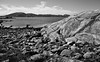
The southernmost cairn is the most overgrown with large and small trees and brush. It is still easily visible due to its size. It is 35 metres in diameter and 7 metres in height. It is a beautiful example of a larger bronze age cairn.
The middle cairn is just 1 metre away from a house and 15 metres north of the largest barrow. It is 25 metres in diameter and 5 metres in height. It is mostly overgrown with grass making it appear more like a barrow but some stones are visible at the top and a large crater is in the centre. Some few trees are also growing on it but the cairn is easily visible.
The northernmost cairn is the easiest visible. It is only some little moss growing on it and most of the stones are visible. It is 20 metres in diameter and around 6 metres in height. Some farm equipment is scattered around it.
You may be viewing yesterday's version of this page. To see the most up to date information please register for a free account.
")
")
")
Do not use the above information on other web sites or publications without permission of the contributor.
Nearby Images from Flickr

The above images may not be of the site on this page, but were taken nearby. They are loaded from Flickr so please click on them for image credits.
Click here to see more info for this site
Nearby sites
Click here to view sites on an interactive map of the areaKey: Red: member's photo, Blue: 3rd party photo, Yellow: other image, Green: no photo - please go there and take one, Grey: site destroyed
Download sites to:
KML (Google Earth)
GPX (GPS waypoints)
CSV (Garmin/Navman)
CSV (Excel)
To unlock full downloads you need to sign up as a Contributory Member. Otherwise downloads are limited to 50 sites.
Turn off the page maps and other distractions
Nearby sites listing. In the following links * = Image available
533m SE 125° Salsnes Carvings* Carving
7.6km NE 48° Smineset Stone Age Settlement* Ancient Village or Settlement
7.8km NE 47° Smineset Iron Age Settlement* Ancient Village or Settlement
8.0km NE 46° Sminesneset Cemetery* Barrow Cemetery
10.4km WNW 298° Ketil's Mound* Long Barrow
25.2km NNW 347° Ødegaarden standing stone* Standing Stone (Menhir)
26.4km NNW 335° Vikestad standing stones* Standing Stones
26.4km SSE 168° Høyknes* Round Barrow(s)
30.1km NW 311° Garstad standing stone* Standing Stone (Menhir)
31.3km SSE 148° Hunn Skage gravfelt* Barrow Cemetery
33.1km SSE 149° Stordalmoen* Barrow Cemetery
34.0km SE 132° Ranem Burial Mounds* Barrow Cemetery
34.5km SE 127° Bjornes* Round Barrow(s)
34.9km SE 127° Lille Skogmo gravfelt* Round Barrow(s)
35.1km SE 140° Gansmo Gravfelt* Barrow Cemetery
35.4km SE 140° Ristad* Round Barrow(s)
35.4km NW 309° Ulsund standing stone* Standing Stone (Menhir)
35.8km SE 128° Fuglem* Round Barrow(s)
38.1km ESE 122° Brannhaugan* Barrow Cemetery
39.3km SE 131° Bertnem Round Mounds* Round Barrow(s)
40.3km N 9° Solsemhula Maleriene* Rock Art
41.2km SE 131° Storem Gravfelt* Barrow Cemetery
42.5km SE 127° Øyem Round Barrow* Round Barrow(s)
43.2km SE 130° Skistad Cemetery* Barrow Cemetery
44.3km SE 124° Rundhaugan* Barrow Cemetery
View more nearby sites and additional images


 We would like to know more about this location. Please feel free to add a brief description and any relevant information in your own language.
 Wir möchten mehr über diese Stätte erfahren. Bitte zögern Sie nicht, eine kurze Beschreibung und relevante Informationen in Deutsch hinzuzufügen.
 Nous aimerions en savoir encore un peu sur les lieux. S'il vous plaît n'hesitez pas à ajouter une courte description et tous les renseignements pertinents dans votre propre langue.
 Quisieramos informarnos un poco más de las lugares. No dude en añadir una breve descripción y otros datos relevantes en su propio idioma.