

<< Text Pages >> Rillenstein Westerhausen - Standing Stone (Menhir) in Germany in Saxony-Anhalt
Submitted by KaiHofmann on Saturday, 23 November 2013 Page Views: 1755
Neolithic and Bronze AgeSite Name: Rillenstein WesterhausenCountry: Germany
NOTE: This site is 1.23 km away from the location you searched for.
Land: Saxony-Anhalt Type: Standing Stone (Menhir)
Nearest Town: Quedlinburg
Latitude: 51.785717N Longitude: 11.137065E
Condition:
| 5 | Perfect |
| 4 | Almost Perfect |
| 3 | Reasonable but with some damage |
| 2 | Ruined but still recognisable as an ancient site |
| 1 | Pretty much destroyed, possibly visible as crop marks |
| 0 | No data. |
| -1 | Completely destroyed |
| 5 | Superb |
| 4 | Good |
| 3 | Ordinary |
| 2 | Not Good |
| 1 | Awful |
| 0 | No data. |
| 5 | Can be driven to, probably with disabled access |
| 4 | Short walk on a footpath |
| 3 | Requiring a bit more of a walk |
| 2 | A long walk |
| 1 | In the middle of nowhere, a nightmare to find |
| 0 | No data. |
| 5 | co-ordinates taken by GPS or official recorded co-ordinates |
| 4 | co-ordinates scaled from a detailed map |
| 3 | co-ordinates scaled from a bad map |
| 2 | co-ordinates of the nearest village |
| 1 | co-ordinates of the nearest town |
| 0 | no data |
Internal Links:
External Links:
Standing Stone (Menhir) in Saxony-Anhalt
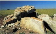
A 1.1m high standing stone with a furrow which forms a kind of antropomorphic look of the stone. It was found near the small town of Thale, today it is located on the terrace of the Schlossmuseum in Quedlinburg.
You may be viewing yesterday's version of this page. To see the most up to date information please register for a free account.
Do not use the above information on other web sites or publications without permission of the contributor.
Nearby Images from Flickr
The above images may not be of the site on this page, but were taken nearby. They are loaded from Flickr so please click on them for image credits.
Click here to see more info for this site
Nearby sites
Click here to view sites on an interactive map of the areaKey: Red: member's photo, Blue: 3rd party photo, Yellow: other image, Green: no photo - please go there and take one, Grey: site destroyed
Download sites to:
KML (Google Earth)
GPX (GPS waypoints)
CSV (Garmin/Navman)
CSV (Excel)
To unlock full downloads you need to sign up as a Contributory Member. Otherwise downloads are limited to 50 sites.
Turn off the page maps and other distractions
Nearby sites listing. In the following links * = Image available
2.7km WNW 291° Eselstall* Stone Circle
4.8km SW 231° Teufelsmauer* Natural Stone / Erratic / Other Natural Feature
6.4km WNW 297° Königsstein bei Westerhausen* Ancient Temple
6.9km WSW 241° Moenchstein Thale Early Christian Sculptured Stone
8.1km WNW 298° Prinzenstein* Standing Stone (Menhir)
8.2km SE 132° Gegensteine Rock Outcrop
8.3km WNW 293° Steinkreis Börnecke Stone Circle
8.3km SW 223° Glockenstein Thale Natural Stone / Erratic / Other Natural Feature
8.7km WNW 299° Börnecke Schwefelquelle Holy Well or Sacred Spring
9.4km W 264° Hamburger Wappen Rock Outcrop
9.4km SW 233° Hexentanzplatz (Thale)* Modern Stone Circle etc
9.8km SW 236° Rosstrappe* Rock Art
10.1km NNW 333° Klusfelsen (Halberstadt)* Rock Outcrop
10.3km NNW 332° Fünffingerfelsen* Rock Outcrop
11.2km NW 313° Gläserner Mönch Rock Outcrop
13.7km NNW 334° Teufelstisch Halberstadt* Chambered Tomb
13.7km NNW 334° Städtisches Museum Halberstadt Museum
14.9km ESE 111° Nagelstein Sinsleben* Natural Stone / Erratic / Other Natural Feature
15.3km WNW 292° Derendorfer Forst* Standing Stones
15.5km ESE 113° Nagelstein Ermsleben* Standing Stone (Menhir)
17.7km WNW 289° Heimburg Menhir* Standing Stone (Menhir)
17.7km WNW 290° Derenburg Menhir* Standing Stone (Menhir)
18.0km WNW 289° Totenhütte Benzingerode* Chambered Tomb
18.3km WNW 289° Grabhügel Benzingerode* Round Barrow(s)
18.4km WNW 289° Langhaus Benzingerode* Ancient Village or Settlement
View more nearby sites and additional images


 We would like to know more about this location. Please feel free to add a brief description and any relevant information in your own language.
 Wir möchten mehr über diese Stätte erfahren. Bitte zögern Sie nicht, eine kurze Beschreibung und relevante Informationen in Deutsch hinzuzufügen.
 Nous aimerions en savoir encore un peu sur les lieux. S'il vous plaît n'hesitez pas à ajouter une courte description et tous les renseignements pertinents dans votre propre langue.
 Quisieramos informarnos un poco más de las lugares. No dude en añadir una breve descripción y otros datos relevantes en su propio idioma.