


<< Our Photo Pages >> Kelibia Fortress - Hillfort in Tunisia
Submitted by AlexHunger on Sunday, 30 March 2008 Page Views: 6152
Iron Age and Later PrehistorySite Name: Kelibia Fortress Alternative Name: Aspis, Clipea FortressCountry: Tunisia
NOTE: This site is 5.805 km away from the location you searched for.
Type: Hillfort
Nearest Town: Kelibia Nearest Village: Kelibia
Latitude: 36.837901N Longitude: 11.115804E
Condition:
| 5 | Perfect |
| 4 | Almost Perfect |
| 3 | Reasonable but with some damage |
| 2 | Ruined but still recognisable as an ancient site |
| 1 | Pretty much destroyed, possibly visible as crop marks |
| 0 | No data. |
| -1 | Completely destroyed |
| 5 | Superb |
| 4 | Good |
| 3 | Ordinary |
| 2 | Not Good |
| 1 | Awful |
| 0 | No data. |
| 5 | Can be driven to, probably with disabled access |
| 4 | Short walk on a footpath |
| 3 | Requiring a bit more of a walk |
| 2 | A long walk |
| 1 | In the middle of nowhere, a nightmare to find |
| 0 | No data. |
| 5 | co-ordinates taken by GPS or official recorded co-ordinates |
| 4 | co-ordinates scaled from a detailed map |
| 3 | co-ordinates scaled from a bad map |
| 2 | co-ordinates of the nearest village |
| 1 | co-ordinates of the nearest town |
| 0 | no data |
Internal Links:
External Links:
")
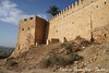
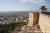
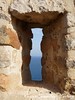
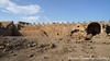
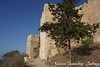
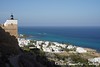
Punic Hillfort dating to at least 4th century. The fortress was later used by very civilisation controlling Tunisia, including the the Romans, Arabs, French and Germans in WWII. Now th fort is used by the Tunisian National Guard/Gendarmerie.
Just above town of Kelibia.
You may be viewing yesterday's version of this page. To see the most up to date information please register for a free account.
Do not use the above information on other web sites or publications without permission of the contributor.
Nearby Images from Flickr
The above images may not be of the site on this page, but were taken nearby. They are loaded from Flickr so please click on them for image credits.
Click here to see more info for this site
Nearby sites
Click here to view sites on an interactive map of the areaKey: Red: member's photo, Blue: 3rd party photo, Yellow: other image, Green: no photo - please go there and take one, Grey: site destroyed
Download sites to:
KML (Google Earth)
GPX (GPS waypoints)
CSV (Garmin/Navman)
CSV (Excel)
To unlock full downloads you need to sign up as a Contributory Member. Otherwise downloads are limited to 50 sites.
Turn off the page maps and other distractions
Nearby sites listing. In the following links * = Image available
241m WSW 246° Cloupia* Ancient Village or Settlement
7.1km W 280° El Harouri Necropolis Rock Cut Tomb
12.2km N 354° Kerkouane* Ancient Village or Settlement
12.4km N 351° Arg el-Ghazouni Necropolis Rock Cut Tomb
12.4km N 353° Kerkouane Museum* Museum
26.9km NNW 337° El Houaria Quarry* Ancient Mine, Quarry or other Industry
56.7km SW 219° Neapolis (Nabeul)* Ancient Village or Settlement
56.8km SW 219° Nabeul Museum Museum
69.5km W 272° Carthage Punic Tomb 3* Barrow Cemetery
69.6km W 272° Carthage Punic Tomb 2* Barrow Cemetery
69.6km W 272° Carthage Punic Tomb 1* Rock Cut Tomb
69.7km W 272° Carthage Magon Quarter* Ancient Village or Settlement
69.8km SW 225° Pupput* Ancient Village or Settlement
70.3km W 272° Carthage Temple of Saturn* Ancient Village or Settlement
70.3km W 271° Carthage Punic Port* Ancient Mine, Quarry or other Industry
70.4km W 272° Carthage Byrsa* Ancient Village or Settlement
70.5km W 271° Carthage Tophet* Ancient Temple
74.4km E 91° Cossyra Acropolis* Ancient Village or Settlement
77.3km E 91° Cossyra Ashtarte Sanctuary Ancient Temple
87.3km W 268° Musee du Bardo* Museum
95.2km ENE 67° Sicilian Channel Monolith* Standing Stone (Menhir)
96.7km WNW 285° Utica Punic Tombs* Chambered Tomb
96.9km SW 220° Castres Shgrania* Ancient Village or Settlement
97.0km WNW 285° Utica Museum* Museum
97.0km WNW 285° Utica* Ancient Village or Settlement
View more nearby sites and additional images


 We would like to know more about this location. Please feel free to add a brief description and any relevant information in your own language.
 Wir möchten mehr über diese Stätte erfahren. Bitte zögern Sie nicht, eine kurze Beschreibung und relevante Informationen in Deutsch hinzuzufügen.
 Nous aimerions en savoir encore un peu sur les lieux. S'il vous plaît n'hesitez pas à ajouter une courte description et tous les renseignements pertinents dans votre propre langue.
 Quisieramos informarnos un poco más de las lugares. No dude en añadir una breve descripción y otros datos relevantes en su propio idioma.