


<< Our Photo Pages >> Phnom Krom - Ancient Temple in Cambodia
Submitted by XIII on Monday, 11 April 2016 Page Views: 1104
Multi-periodSite Name: Phnom KromCountry: Cambodia
NOTE: This site is 30.154 km away from the location you searched for.
Type: Ancient Temple
Nearest Town: Siem Reap
Latitude: 13.285730N Longitude: 103.812180E
Condition:
| 5 | Perfect |
| 4 | Almost Perfect |
| 3 | Reasonable but with some damage |
| 2 | Ruined but still recognisable as an ancient site |
| 1 | Pretty much destroyed, possibly visible as crop marks |
| 0 | No data. |
| -1 | Completely destroyed |
| 5 | Superb |
| 4 | Good |
| 3 | Ordinary |
| 2 | Not Good |
| 1 | Awful |
| 0 | No data. |
| 5 | Can be driven to, probably with disabled access |
| 4 | Short walk on a footpath |
| 3 | Requiring a bit more of a walk |
| 2 | A long walk |
| 1 | In the middle of nowhere, a nightmare to find |
| 0 | No data. |
| 5 | co-ordinates taken by GPS or official recorded co-ordinates |
| 4 | co-ordinates scaled from a detailed map |
| 3 | co-ordinates scaled from a bad map |
| 2 | co-ordinates of the nearest village |
| 1 | co-ordinates of the nearest town |
| 0 | no data |
Be the first person to rate this site - see the 'Contribute!' box in the right hand menu.
Internal Links:
External Links:
")
Phnom Krom is located to 12 kilometers southwest of Siem Reap town.
There is an Angkorian temple on top of the hill. It is a Hindu shrine dedicated to Shiva, Vishnu and Brahma.
The temple was built at the end of the 9th century, during the reign of King Yasovarman (889 A.D.-910 A.D.).
Source and further reading: wikipedia
You may be viewing yesterday's version of this page. To see the most up to date information please register for a free account.
")
")
Do not use the above information on other web sites or publications without permission of the contributor.
Nearby Images from Flickr
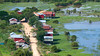
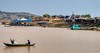

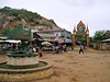

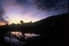
The above images may not be of the site on this page, but were taken nearby. They are loaded from Flickr so please click on them for image credits.
Click here to see more info for this site
Nearby sites
Click here to view sites on an interactive map of the areaKey: Red: member's photo, Blue: 3rd party photo, Yellow: other image, Green: no photo - please go there and take one, Grey: site destroyed
Download sites to:
KML (Google Earth)
GPX (GPS waypoints)
CSV (Garmin/Navman)
CSV (Excel)
To unlock full downloads you need to sign up as a Contributory Member. Otherwise downloads are limited to 50 sites.
Turn off the page maps and other distractions
Nearby sites listing. In the following links * = Image available
5.2km NE 36° Wat Athvea* Ancient Temple
10.4km NNE 30° Angkor National Museum* Museum
15.0km N 359° Prasat Ta Noreay Ancient Temple
15.2km NNE 23° Angkor Wat* Ancient Temple
15.3km N 351° Prasat Kas Ho Ancient Temple
15.4km NNE 19° Ta Prohm Kel* Ancient Temple
15.9km E 80° Prasat Totoeng Thngai Ancient Temple
15.9km NNW 346° Ak Yum Ancient Temple
16.1km NNE 17° Phnom Bakheng* Ancient Temple
16.3km NNE 18° Baksei Chamkrong* Ancient Temple
16.3km NNE 17° Prasat Bei* Ancient Temple
16.6km NNE 18° Angkor Thom South Gate* Ancient Temple
16.6km N 355° West Mebon Ancient Temple
16.9km NNW 339° Prasat Prei Kmeng Ancient Temple
17.1km E 81° Prasat Trapeang Phong Ancient Temple
17.6km NNE 12° Angkor Thom West Gate* Ancient Temple
17.6km ENE 75° Prasat Prei Monti* Ancient Temple
17.7km NNE 32° Prasat Kravan* Ancient Temple
18.0km NNE 16° Bayon* Ancient Temple
18.2km NNE 15° Baphuon* Ancient Village or Settlement
18.4km NNE 15° Phimeanakas* Ancient Temple
18.4km ENE 72° Bakong* Ancient Temple
18.5km NNE 16° Angkor Thom* Ancient Temple
18.5km NNE 16° Terrace of the Elephants* Carving
18.5km NNE 30° Banteay Kdei* Ancient Temple
View more nearby sites and additional images


 We would like to know more about this location. Please feel free to add a brief description and any relevant information in your own language.
 Wir möchten mehr über diese Stätte erfahren. Bitte zögern Sie nicht, eine kurze Beschreibung und relevante Informationen in Deutsch hinzuzufügen.
 Nous aimerions en savoir encore un peu sur les lieux. S'il vous plaît n'hesitez pas à ajouter une courte description et tous les renseignements pertinents dans votre propre langue.
 Quisieramos informarnos un poco más de las lugares. No dude en añadir una breve descripción y otros datos relevantes en su propio idioma.