 with our Megalithic Portal iPhone app")

<< Our Photo Pages >> Shishkino - Rock Art in Russia
Submitted by kaiHofmann on Wednesday, 22 May 2013 Page Views: 3815
Rock ArtSite Name: Shishkino Alternative Name: Schischkino, SzyszkinoCountry: Russia
NOTE: This site is 354.397 km away from the location you searched for.
Type: Rock Art
Nearest Town: Kacug Nearest Village: Shishkino
Latitude: 54.006609N Longitude: 105.703920E
Condition:
| 5 | Perfect |
| 4 | Almost Perfect |
| 3 | Reasonable but with some damage |
| 2 | Ruined but still recognisable as an ancient site |
| 1 | Pretty much destroyed, possibly visible as crop marks |
| 0 | No data. |
| -1 | Completely destroyed |
| 5 | Superb |
| 4 | Good |
| 3 | Ordinary |
| 2 | Not Good |
| 1 | Awful |
| 0 | No data. |
| 5 | Can be driven to, probably with disabled access |
| 4 | Short walk on a footpath |
| 3 | Requiring a bit more of a walk |
| 2 | A long walk |
| 1 | In the middle of nowhere, a nightmare to find |
| 0 | No data. |
| 5 | co-ordinates taken by GPS or official recorded co-ordinates |
| 4 | co-ordinates scaled from a detailed map |
| 3 | co-ordinates scaled from a bad map |
| 2 | co-ordinates of the nearest village |
| 1 | co-ordinates of the nearest town |
| 0 | no data |
Be the first person to rate this site - see the 'Contribute!' box in the right hand menu.
Internal Links:
External Links:
")
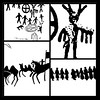
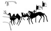
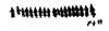
Rock engravings on the 3km long Shishkino rock above the upper Lena river in Sibiria. The rock walls are laced with wonderful paintings/engravings of humans, animals and ornaments from palaeolithic to neolithic.
You may be viewing yesterday's version of this page. To see the most up to date information please register for a free account.
Do not use the above information on other web sites or publications without permission of the contributor.
Nearby Images from Flickr


The above images may not be of the site on this page, but were taken nearby. They are loaded from Flickr so please click on them for image credits.
Click here to see more info for this site
Nearby sites
Click here to view sites on an interactive map of the areaKey: Red: member's photo, Blue: 3rd party photo, Yellow: other image, Green: no photo - please go there and take one, Grey: site destroyed
Download sites to:
KML (Google Earth)
GPX (GPS waypoints)
CSV (Garmin/Navman)
CSV (Excel)
To unlock full downloads you need to sign up as a Contributory Member. Otherwise downloads are limited to 50 sites.
Turn off the page maps and other distractions
Nearby sites listing. In the following links * = Image available
145.7km SSE 158° Sacred mountain Yord* Artificial Mound
156.0km SSE 161° Sagan-Zaba Cape Rock Art
190.8km SW 231° Malta Paleolithic Settlement* Ancient Village or Settlement
214.7km SSW 207° Irkutsk Museum Of Regional Studies* Museum
267.7km SSE 151° Ethnographic Museum of Buryatia* Museum
272.8km SSE 152° Museum of Buryatia History* Museum
276.3km SSE 154° Big Ivolginskoe settlement* Ancient Village or Settlement
383.2km S 175° Orgoyton-2 Burial Ground* Chambered Tomb
383.3km S 175° Orgoyton-1 Burial Ground* Chambered Tomb
625.4km SW 222° Moron Deer Stones* Standing Stones
735.5km ESE 105° Ust-Chorninsk settlement* Ancient Village or Settlement
785.7km SW 216° Tariat Deer Stone* Standing Stones
797.5km WSW 256° Republican Museum of Kyzyl* Museum
805.6km SSE 147° Duurlig Nars Burial Chamber or Dolmen
828.2km W 260° Arzhan Scythian royal necropolis* Barrow Cemetery
844.4km SW 235° Lake Oygon Round Barrows Round Barrow(s)
846.6km WNW 290° Krasnoyarsk Regional Museum of Local Lore* Museum
850.4km WNW 290° Settlement Afontova Mountain* Ancient Village or Settlement
890.0km ESE 111° Konduy settlement* Ancient Village or Settlement
929.4km W 259° Ancient sanctuary Chaa-Holl* Rock Cut Tomb
934.4km W 274° Museum Kyzlasov L.R.* Museum
975.3km W 275° Great Salbyk Kurgan* Pyramid / Mastaba
1024.3km W 279° Tuim Cromlech* Stone Circle
1034.8km W 281° Complex Sunduki* Natural Stone / Erratic / Other Natural Feature
1056.7km W 279° Paleolithic settlement Small Syya* Ancient Village or Settlement
View more nearby sites and additional images


 We would like to know more about this location. Please feel free to add a brief description and any relevant information in your own language.
 Wir möchten mehr über diese Stätte erfahren. Bitte zögern Sie nicht, eine kurze Beschreibung und relevante Informationen in Deutsch hinzuzufügen.
 Nous aimerions en savoir encore un peu sur les lieux. S'il vous plaît n'hesitez pas à ajouter une courte description et tous les renseignements pertinents dans votre propre langue.
 Quisieramos informarnos un poco más de las lugares. No dude en añadir una breve descripción y otros datos relevantes en su propio idioma.