 with our Megalithic Portal iPhone app")


<< Other Photo Pages >> Lopburi Temples - Ancient Temple in Thailand
Submitted by KaiHofmann on Wednesday, 08 March 2017 Page Views: 1519
Multi-periodSite Name: Lopburi TemplesCountry: Thailand Type: Ancient Temple
Nearest Town: Lopburi
Latitude: 14.800000N Longitude: 100.626944E
Condition:
| 5 | Perfect |
| 4 | Almost Perfect |
| 3 | Reasonable but with some damage |
| 2 | Ruined but still recognisable as an ancient site |
| 1 | Pretty much destroyed, possibly visible as crop marks |
| 0 | No data. |
| -1 | Completely destroyed |
| 5 | Superb |
| 4 | Good |
| 3 | Ordinary |
| 2 | Not Good |
| 1 | Awful |
| 0 | No data. |
| 5 | Can be driven to, probably with disabled access |
| 4 | Short walk on a footpath |
| 3 | Requiring a bit more of a walk |
| 2 | A long walk |
| 1 | In the middle of nowhere, a nightmare to find |
| 0 | No data. |
| 5 | co-ordinates taken by GPS or official recorded co-ordinates |
| 4 | co-ordinates scaled from a detailed map |
| 3 | co-ordinates scaled from a bad map |
| 2 | co-ordinates of the nearest village |
| 1 | co-ordinates of the nearest town |
| 0 | no data |
Internal Links:
External Links:
")
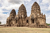
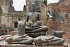
The town of Lopburi was probably founded in the 7th century CE. There are many ancient temples to visit like the Wat Phra Sri Rattana Mahathat temple, the Phra Prang Sam Yot, both built in the 11th century CE by the Khmer people and the king´s palace Narai Ratchaniwet.
You may be viewing yesterday's version of this page. To see the most up to date information please register for a free account.
Do not use the above information on other web sites or publications without permission of the contributor.
Nearby Images from Flickr
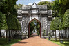
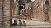
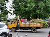

The above images may not be of the site on this page, but were taken nearby. They are loaded from Flickr so please click on them for image credits.
Click here to see more info for this site
Nearby sites
Click here to view sites on an interactive map of the areaKey: Red: member's photo, Blue: 3rd party photo, Yellow: other image, Green: no photo - please go there and take one, Grey: site destroyed
Download sites to:
KML (Google Earth)
GPX (GPS waypoints)
CSV (Garmin/Navman)
CSV (Excel)
To unlock full downloads you need to sign up as a Contributory Member. Otherwise downloads are limited to 50 sites.
Turn off the page maps and other distractions
Nearby sites listing. In the following links * = Image available
49.9km S 189° Ayutthaya Historical Park* Ancient Village or Settlement
116.8km S 187° Bangkok National Museum* Museum
123.5km SSW 208° Phra Prathon Chedi* Ancient Temple
124.9km SSW 209° Phra Pathommachedi* Ancient Temple
147.3km SSE 158° Khok Phanom Di* Ancient Village or Settlement
184.1km ENE 73° Ban Non Wat Ancient Village or Settlement
201.9km SSW 201° Wat Kamphaeng Laeng* Ancient Temple
276.6km NNW 334° Sukothai* Ancient Village or Settlement
278.5km ESE 107° Banteay Chhmar Ancient Temple
330.9km ESE 123° Wat Ek Phnom* Ancient Temple
340.4km SE 127° Wat Banan Ancient Temple
370.5km ESE 114° Prasat Prei Kmeng Ancient Temple
372.5km ESE 114° Ak Yum Ancient Temple
374.0km ESE 114° Prasat Kas Ho Ancient Temple
374.4km ESE 114° West Mebon Ancient Temple
374.6km NNE 29° Phu Phra Bat Historical Park Rock Art
375.8km ESE 114° Prasat Ta Noreay Ancient Temple
377.0km ESE 113° Prasat Banteay Thom* Ancient Temple
377.3km ESE 113° Prasat Prei Ancient Temple
378.5km ESE 113° Angkor Thom West Gate* Ancient Temple
379.1km ESE 113° Preah Palilay Ancient Temple
379.3km ESE 113° Angkor Thom North Gate* Ancient Temple
379.4km ESE 113° Phimeanakas* Ancient Temple
379.4km ESE 113° Tep Pranam Ancient Temple
379.4km ESE 113° Baphuon* Ancient Village or Settlement
View more nearby sites and additional images


 We would like to know more about this location. Please feel free to add a brief description and any relevant information in your own language.
 Wir möchten mehr über diese Stätte erfahren. Bitte zögern Sie nicht, eine kurze Beschreibung und relevante Informationen in Deutsch hinzuzufügen.
 Nous aimerions en savoir encore un peu sur les lieux. S'il vous plaît n'hesitez pas à ajouter une courte description et tous les renseignements pertinents dans votre propre langue.
 Quisieramos informarnos un poco más de las lugares. No dude en añadir una breve descripción y otros datos relevantes en su propio idioma.