


<< Our Photo Pages >> Tomba del Diavolino 2 - Chambered Cairn in Italy in Toscana
Submitted by Martin_L on Monday, 20 September 2010 Page Views: 3784
Neolithic and Bronze AgeSite Name: Tomba del Diavolino 2Country: Italy Region: Toscana Type: Chambered Cairn
Nearest Town: Grosseto Nearest Village: Vetulonia
Latitude: 42.875648N Longitude: 10.994214E
Condition:
| 5 | Perfect |
| 4 | Almost Perfect |
| 3 | Reasonable but with some damage |
| 2 | Ruined but still recognisable as an ancient site |
| 1 | Pretty much destroyed, possibly visible as crop marks |
| 0 | No data. |
| -1 | Completely destroyed |
| 5 | Superb |
| 4 | Good |
| 3 | Ordinary |
| 2 | Not Good |
| 1 | Awful |
| 0 | No data. |
| 5 | Can be driven to, probably with disabled access |
| 4 | Short walk on a footpath |
| 3 | Requiring a bit more of a walk |
| 2 | A long walk |
| 1 | In the middle of nowhere, a nightmare to find |
| 0 | No data. |
| 5 | co-ordinates taken by GPS or official recorded co-ordinates |
| 4 | co-ordinates scaled from a detailed map |
| 3 | co-ordinates scaled from a bad map |
| 2 | co-ordinates of the nearest village |
| 1 | co-ordinates of the nearest town |
| 0 | no data |
Internal Links:
External Links:
I have visited· I would like to visit
Martin_L has visited here
")
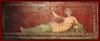
Possibly it depicts Charon.
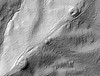
The tomb is rather impressive. The cairns' diameter is 80m. A 40m long passage (dromos) the last 15m of which are roofed leads into a square chamber with a height of 15m.
You may be viewing yesterday's version of this page. To see the most up to date information please register for a free account.
")
Do not use the above information on other web sites or publications without permission of the contributor.
Nearby Images from Flickr


The above images may not be of the site on this page, but were taken nearby. They are loaded from Flickr so please click on them for image credits.
Click here to see more info for this site
Nearby sites
Click here to view sites on an interactive map of the areaKey: Red: member's photo, Blue: 3rd party photo, Yellow: other image, Green: no photo - please go there and take one, Grey: site destroyed
Download sites to:
KML (Google Earth)
GPX (GPS waypoints)
CSV (Garmin/Navman)
CSV (Excel)
To unlock full downloads you need to sign up as a Contributory Member. Otherwise downloads are limited to 50 sites.
Turn off the page maps and other distractions
Nearby sites listing. In the following links * = Image available
2.6km SW 223° Vetulonia Mura dell' Arce* Ancient Village or Settlement
14.6km ESE 110° Roselle* Hillfort
41.4km WNW 288° Populonia Necropolis* Rock Cut Tomb
45.1km NE 45° Poggio Civitate Ancient Village or Settlement
56.7km SSE 155° Cosa.* Hillfort
57.5km ESE 115° Ildebranda Tomb* Rock Cut Tomb
57.5km ESE 115° Via Cava di Poggio Prisca* Ancient Trackway
57.9km ESE 115° Via cava di S. Sebastiano* Ancient Trackway
58.2km ESE 115° Tomba della Sirena* Rock Cut Tomb
58.9km ESE 114° Sovana Necropolis* Rock Cut Tomb
65.5km ESE 109° Vitozza* Cave or Rock Shelter
66.6km WSW 258° Sassiritti Standing Stone (Menhir)
69.8km WSW 258° Piane alla Sughera Chambered Tomb
72.5km E 80° Civic Archaeological Museum* Museum
82.0km SE 129° San Giulano Rock Cut tombs Rock Cut Tomb
92.3km E 100° Necropoli del Crocifisso del Tufo Rock Cut Tomb
95.3km SE 136° Tarquinia* Ancient Village or Settlement
98.2km SE 127° Norchia Etruscan Necropolis* Rock Cut Tomb
106.1km SE 128° Pian di Vescovo Rock Cut Tomb
109.7km SE 131° Casale Vignale Necropolis Chambered Cairn
110.8km SE 131° Civitella Cesi Etruscan Tomb* Rock Cut Tomb
111.4km ESE 117° Mount Cimino Votive Site* Ancient Temple
112.2km SE 127° Barbarano Romano Etruscan Necropolis Chambered Tomb
112.5km ESE 113° Bomarzo Etruscan 'Pyramid' Altar* Ancient Temple
116.4km ENE 77° The Hypogeum of the Volumni* Rock Cut Tomb
View more nearby sites and additional images


 We would like to know more about this location. Please feel free to add a brief description and any relevant information in your own language.
 Wir möchten mehr über diese Stätte erfahren. Bitte zögern Sie nicht, eine kurze Beschreibung und relevante Informationen in Deutsch hinzuzufügen.
 Nous aimerions en savoir encore un peu sur les lieux. S'il vous plaît n'hesitez pas à ajouter une courte description et tous les renseignements pertinents dans votre propre langue.
 Quisieramos informarnos un poco más de las lugares. No dude en añadir una breve descripción y otros datos relevantes en su propio idioma.