

<< Text Pages >> Mutsbichl Schalensteine - Rock Art in Austria
Submitted by KaiHofmann on Wednesday, 30 November 2011 Page Views: 2536
Rock ArtSite Name: Mutsbichl SchalensteineCountry: Austria
NOTE: This site is 5.638 km away from the location you searched for.
Type: Rock Art
Nearest Town: Vent Nearest Village: Vent
Latitude: 46.861701N Longitude: 10.928613E
Condition:
| 5 | Perfect |
| 4 | Almost Perfect |
| 3 | Reasonable but with some damage |
| 2 | Ruined but still recognisable as an ancient site |
| 1 | Pretty much destroyed, possibly visible as crop marks |
| 0 | No data. |
| -1 | Completely destroyed |
| 5 | Superb |
| 4 | Good |
| 3 | Ordinary |
| 2 | Not Good |
| 1 | Awful |
| 0 | No data. |
| 5 | Can be driven to, probably with disabled access |
| 4 | Short walk on a footpath |
| 3 | Requiring a bit more of a walk |
| 2 | A long walk |
| 1 | In the middle of nowhere, a nightmare to find |
| 0 | No data. |
| 5 | co-ordinates taken by GPS or official recorded co-ordinates |
| 4 | co-ordinates scaled from a detailed map |
| 3 | co-ordinates scaled from a bad map |
| 2 | co-ordinates of the nearest village |
| 1 | co-ordinates of the nearest town |
| 0 | no data |
Be the first person to rate this site - see the 'Contribute!' box in the right hand menu.
Internal Links:
External Links:
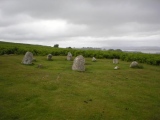
Cup-marked stones at the Mutsbichl Mountain (2360m)
You may be viewing yesterday's version of this page. To see the most up to date information please register for a free account.
Do not use the above information on other web sites or publications without permission of the contributor.
Nearby Images from Flickr
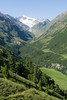
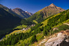
The above images may not be of the site on this page, but were taken nearby. They are loaded from Flickr so please click on them for image credits.
Click here to see more info for this site
Nearby sites
Click here to view sites on an interactive map of the areaKey: Red: member's photo, Blue: 3rd party photo, Yellow: other image, Green: no photo - please go there and take one, Grey: site destroyed
Download sites to:
KML (Google Earth)
GPX (GPS waypoints)
CSV (Garmin/Navman)
CSV (Excel)
To unlock full downloads you need to sign up as a Contributory Member. Otherwise downloads are limited to 50 sites.
Turn off the page maps and other distractions
Nearby sites listing. In the following links * = Image available
1.6km SW 225° Hohler Stein Kaser Natural Stone / Erratic / Other Natural Feature
3.7km SSW 203° Kaser Menhir Standing Stone (Menhir)
6.4km NNE 34° Heiligkreuz Teufelsfelsen Rock Art
10.3km NE 53° Lenzenalm Schalenstein Rock Art
11.4km SW 216° Ötzi Memorial* Marker Stone
13.2km NNE 29° Schlangenfelsen (Snake's rock) Rock Art
13.5km NNE 27° Sölden menhir* Standing Stone (Menhir)
14.4km NE 36° Windachtal Schalenstein I Rock Art
16.2km SSW 200° ArcheoPark and Museum Val Senales* Museum
17.7km ENE 59° Windachtal Schalenstein II Rock Art
20.0km SE 138° Spronser Seen (Sprons Lakes)* Rock Art
22.2km N 9° Burgstein Schalenstein Rock Art
23.8km N 359° Innerbergalm Schalenstein Rock Art
25.4km SE 144° Stone Age 2001* Modern Stone Circle etc
26.4km S 188° Untere Grübelplatte (Schalenstein)* Rock Art
30.0km N 1° Ötzi Village* Museum
31.2km NW 320° Schalenstein Prutz Rock Art
37.4km N 352° Sautens Opferstein Natural Stone / Erratic / Other Natural Feature
38.6km NE 43° Cupstone Lithagrub-Profegl Alm* Rock Art
40.5km NE 44° Cupstone Menhir Viggar Valley Tyrol* Rock Art
48.6km W 273° Heidelberg Hut Ancient Village or Settlement
51.5km SE 141° South Tyrol Museum of Archaeology* Museum
53.4km NE 47° Cupstone Slabs-Graveyard Tarzens* Rock Art
53.8km SE 134° Der Menhir von Wolfsgruben* Standing Stone (Menhir)
54.2km NE 43° Goldbichl Natural Stone / Erratic / Other Natural Feature
View more nearby sites and additional images


 We would like to know more about this location. Please feel free to add a brief description and any relevant information in your own language.
 Wir möchten mehr über diese Stätte erfahren. Bitte zögern Sie nicht, eine kurze Beschreibung und relevante Informationen in Deutsch hinzuzufügen.
 Nous aimerions en savoir encore un peu sur les lieux. S'il vous plaît n'hesitez pas à ajouter une courte description et tous les renseignements pertinents dans votre propre langue.
 Quisieramos informarnos un poco más de las lugares. No dude en añadir una breve descripción y otros datos relevantes en su propio idioma.