


<< Our Photo Pages >> Meescheberg - Artificial Mound in Germany in Lower Saxony, Bremen
Submitted by AlexHunger on Tuesday, 27 September 2005 Page Views: 2962
Multi-periodSite Name: MeeschebergCountry: Germany
NOTE: This site is 4.044 km away from the location you searched for.
Land: Lower Saxony, Bremen Type: Artificial Mound
Nearest Town: Wolfenbüttel Nearest Village: Klein Vahlberg
Latitude: 52.118880N Longitude: 10.716050E
Condition:
| 5 | Perfect |
| 4 | Almost Perfect |
| 3 | Reasonable but with some damage |
| 2 | Ruined but still recognisable as an ancient site |
| 1 | Pretty much destroyed, possibly visible as crop marks |
| 0 | No data. |
| -1 | Completely destroyed |
| 5 | Superb |
| 4 | Good |
| 3 | Ordinary |
| 2 | Not Good |
| 1 | Awful |
| 0 | No data. |
| 5 | Can be driven to, probably with disabled access |
| 4 | Short walk on a footpath |
| 3 | Requiring a bit more of a walk |
| 2 | A long walk |
| 1 | In the middle of nowhere, a nightmare to find |
| 0 | No data. |
| 5 | co-ordinates taken by GPS or official recorded co-ordinates |
| 4 | co-ordinates scaled from a detailed map |
| 3 | co-ordinates scaled from a bad map |
| 2 | co-ordinates of the nearest village |
| 1 | co-ordinates of the nearest town |
| 0 | no data |
Internal Links:
External Links:
")
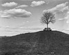
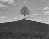
Neolithic tumulus, later reused during middle ages just south of town along main road. 178 meters Altitude.
You may be viewing yesterday's version of this page. To see the most up to date information please register for a free account.
Do not use the above information on other web sites or publications without permission of the contributor.
Nearby Images from Flickr


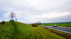

The above images may not be of the site on this page, but were taken nearby. They are loaded from Flickr so please click on them for image credits.
Click here to see more info for this site
Nearby sites
Click here to view sites on an interactive map of the areaKey: Red: member's photo, Blue: 3rd party photo, Yellow: other image, Green: no photo - please go there and take one, Grey: site destroyed
Download sites to:
KML (Google Earth)
GPX (GPS waypoints)
CSV (Garmin/Navman)
CSV (Excel)
To unlock full downloads you need to sign up as a Contributory Member. Otherwise downloads are limited to 50 sites.
Turn off the page maps and other distractions
Nearby sites listing. In the following links * = Image available
568m N 1° Klein Vahlberg Menhir* Standing Stone (Menhir)
988m N 11° Galgenberg von Klein Vahlberg* Artificial Mound
2.7km WSW 258° Remlingen Totenhütte* Chambered Tomb
7.8km N 355° Evessen Tumulus* Round Barrow(s)
8.9km ESE 113° Watenstedt Ringstein Sculptured Stone
9.0km N 11° Evessen Steingrab* Chambered Tomb
10.0km NNE 31° Tetzelstein* Standing Stone (Menhir)
11.8km N 1° Kleiner Tafelberg Hügelgrab* Artificial Mound
12.5km SW 217° Summstein Hornburg* Modern Stone Circle etc
12.9km ESE 112° Watenstedt Hünenburg* Hillfort
13.3km WNW 293° Braunschweigisches Landesmuseum* Museum
15.5km NNE 26° Summstein Königslutter am Elm Modern Stone Circle etc
18.9km E 87° Paläon* Museum
19.7km NNE 33° Archäologischer Lehrpfad Groß Steinum* Museum
19.7km NNE 33° Wippstein* Natural Stone / Erratic / Other Natural Feature
19.8km NNE 33° Bockshornklippe* Natural Stone / Erratic / Other Natural Feature
19.8km NE 41° Süpplingenburg Schalenstein* Rock Art
20.1km NE 44° Großsteingrab am Sandteich* Chambered Tomb
20.2km NNE 31° Grosssteingrab am Dorm* Chambered Tomb
22.2km NE 56° Lübbensteine Südgrab* Chambered Tomb
22.3km NE 56° Lübbensteine Nordgrab* Chambered Tomb
22.7km S 174° Brotstein* Standing Stone (Menhir)
22.8km WSW 241° Scheibenkreuzstein Liebenburg* Early Christian Sculptured Stone
27.6km ENE 70° Marienborn Opferstein* Chambered Tomb
27.7km ENE 71° Marienborn Tumuli No1* Artificial Mound
View more nearby sites and additional images


 We would like to know more about this location. Please feel free to add a brief description and any relevant information in your own language.
 Wir möchten mehr über diese Stätte erfahren. Bitte zögern Sie nicht, eine kurze Beschreibung und relevante Informationen in Deutsch hinzuzufügen.
 Nous aimerions en savoir encore un peu sur les lieux. S'il vous plaît n'hesitez pas à ajouter une courte description et tous les renseignements pertinents dans votre propre langue.
 Quisieramos informarnos un poco más de las lugares. No dude en añadir una breve descripción y otros datos relevantes en su propio idioma.