

<< Our Photo Pages >> Regildshøj - Round Barrow(s) in Denmark in Midtjylland
Submitted by Tonnox on Thursday, 12 May 2022 Page Views: 386
Neolithic and Bronze AgeSite Name: Regildshøj Alternative Name: RelshøjCountry: Denmark County: Midtjylland Type: Round Barrow(s)
Nearest Town: Gjerrild Nearest Village: Bønnerup
Latitude: 56.516320N Longitude: 10.749150E
Condition:
| 5 | Perfect |
| 4 | Almost Perfect |
| 3 | Reasonable but with some damage |
| 2 | Ruined but still recognisable as an ancient site |
| 1 | Pretty much destroyed, possibly visible as crop marks |
| 0 | No data. |
| -1 | Completely destroyed |
| 5 | Superb |
| 4 | Good |
| 3 | Ordinary |
| 2 | Not Good |
| 1 | Awful |
| 0 | No data. |
| 5 | Can be driven to, probably with disabled access |
| 4 | Short walk on a footpath |
| 3 | Requiring a bit more of a walk |
| 2 | A long walk |
| 1 | In the middle of nowhere, a nightmare to find |
| 0 | No data. |
| 5 | co-ordinates taken by GPS or official recorded co-ordinates |
| 4 | co-ordinates scaled from a detailed map |
| 3 | co-ordinates scaled from a bad map |
| 2 | co-ordinates of the nearest village |
| 1 | co-ordinates of the nearest town |
| 0 | no data |
Internal Links:
External Links:
I have visited· I would like to visit
Tonnox visited on 15th Apr 2022 - their rating: Cond: 4 Amb: 5 Access: 4
")
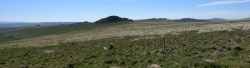
Regildshøj. Round barrow. 4 x 25 x 14 meter. 2 old diggings on the top. Some kerbstones visible.
More information: Danish Sites and Monuments Record:140110-26
“Fortidsmindedata Copyright Kulturarvstyrelsen”
You may be viewing yesterday's version of this page. To see the most up to date information please register for a free account.
")
")
")
")
")
")
Do not use the above information on other web sites or publications without permission of the contributor.
Click here to see more info for this site
Nearby sites
Click here to view sites on an interactive map of the areaKey: Red: member's photo, Blue: 3rd party photo, Yellow: other image, Green: no photo - please go there and take one, Grey: site destroyed
Download sites to:
KML (Google Earth)
GPX (GPS waypoints)
CSV (Garmin/Navman)
CSV (Excel)
To unlock full downloads you need to sign up as a Contributory Member. Otherwise downloads are limited to 50 sites.
Turn off the page maps and other distractions
Nearby sites listing. In the following links * = Image available
687m NNE 15° Emmedsbo Rundhøj 2 Round Barrow(s)
731m SSW 197° Emmedsbo Langdysse 1 Long Barrow
753m NW 305° Emmedsbo Thinghøj Round Barrow(s)
1.0km NW 307° Emmedsbo Rundhøj 1 Round Barrow(s)
1.2km N 9° Emmedsbo Langdysse 3 Long Barrow
1.2km NNE 29° Emmedsbo Langdysse 4 Long Barrow
1.3km N 355° Emmedsbo Langdysse 2* Long Barrow
1.7km N 7° Emmedsbo Runddysse 2 Burial Chamber or Dolmen
2.0km SSW 205° Hemmed Egehøj Stenkiste Cist
2.0km NNE 19° Emmedsbo Runddysse 1 Burial Chamber or Dolmen
2.5km NNE 27° Emmedsbo Runddysse 3 Burial Chamber or Dolmen
3.8km W 274° Birkelund Jættestue 1* Passage Grave
4.1km W 273° Birkelund Jættestue 2* Passage Grave
5.0km SE 146° Rimsø-sten* Carving
5.1km ENE 75° Gjerrild Troldhøj Langdysse* Long Barrow
5.5km W 268° Mejlgård Nederskov Stenkiste 1 Cist
5.8km W 270° Meilgård Langdysse Long Barrow
5.8km W 266° Mejlgård Nederskov Stenkiste 2 Cist
9.1km WSW 238° Stenvad Hede Jættestue* Passage Grave
9.2km SW 224° Stenvad Vrænghøj Langdysse Long Barrow
9.5km WSW 247° Fjellerup Mark Jættestue Passage Grave
9.6km WSW 238° Stenvad Hede Runddysse* Burial Chamber or Dolmen
9.7km SW 236° Stenvad 50 Kroner Dysse* Long Barrow
9.9km S 172° Slemming Jættestue* Passage Grave
10.1km SW 228° Ulstrup Jættestue Passage Grave
View more nearby sites and additional images


 We would like to know more about this location. Please feel free to add a brief description and any relevant information in your own language.
 Wir möchten mehr über diese Stätte erfahren. Bitte zögern Sie nicht, eine kurze Beschreibung und relevante Informationen in Deutsch hinzuzufügen.
 Nous aimerions en savoir encore un peu sur les lieux. S'il vous plaît n'hesitez pas à ajouter une courte description et tous les renseignements pertinents dans votre propre langue.
 Quisieramos informarnos un poco más de las lugares. No dude en añadir una breve descripción y otros datos relevantes en su propio idioma.