

<< Our Photo Pages >> Adalsborgen Hillfort - Hillfort in Norway in Vestfold
Submitted by kenntha88 on Sunday, 22 October 2023 Page Views: 97
Iron Age and Later PrehistorySite Name: Adalsborgen Hillfort Alternative Name: BorgåsenCountry: Norway
NOTE: This site is 1.982 km away from the location you searched for.
Fylke: Vestfold Type: Hillfort
Nearest Town: Horten Nearest Village: Skoppum
Latitude: 59.374977N Longitude: 10.397623E
Condition:
| 5 | Perfect |
| 4 | Almost Perfect |
| 3 | Reasonable but with some damage |
| 2 | Ruined but still recognisable as an ancient site |
| 1 | Pretty much destroyed, possibly visible as crop marks |
| 0 | No data. |
| -1 | Completely destroyed |
| 5 | Superb |
| 4 | Good |
| 3 | Ordinary |
| 2 | Not Good |
| 1 | Awful |
| 0 | No data. |
| 5 | Can be driven to, probably with disabled access |
| 4 | Short walk on a footpath |
| 3 | Requiring a bit more of a walk |
| 2 | A long walk |
| 1 | In the middle of nowhere, a nightmare to find |
| 0 | No data. |
| 5 | co-ordinates taken by GPS or official recorded co-ordinates |
| 4 | co-ordinates scaled from a detailed map |
| 3 | co-ordinates scaled from a bad map |
| 2 | co-ordinates of the nearest village |
| 1 | co-ordinates of the nearest town |
| 0 | no data |
Internal Links:
External Links:
")
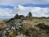
The hillfort which is located in the middle of a local mountain area is located on a hill that consists of three smaller hills. The terrain falls off steeply in the west to a nearby field, fairly steep in the north, precipitous in the east. In the south the slope is much less steep. The top plateau and the protruding hills are fortified by 3 walls. From a small parking lot next to the main highway there is a footpath leading up to the hillfort.
All along the south side and farthest to the south west is the largest of the walls. Wall 1: It begins at a ridge which in the west falls off steeply towards the valley floor. Along the edge of the mountain slope that encircles the hillforts lowest plateau, the wall runs in a SE-NW direction for approx. 12m, maximum width 4.5m, up to 1m high. It runs along the ridge which forms a 90 degree angle inwards to the hillfort in an l of 18m towards the NE. Here, the wall is heavily collapsed. Much of the material lies scattered on the slope. Furthermore, the wall cuts off a flat, wide valley between the knobs and it turns 90 degrees again, goes NW-SE again for approx. 40m, width up to 12m. Here is a small round recess, d 3m, depth 0.6m.
Farthest east is a bulge in the wall with a larger oval-shaped room, 3x4m. Along its eastern side, a clear path runs from S-N through the wall. A section of stone has been added to form an island-like mouth to an unstructured gate from the outside. The V-straight part of this mouth is part of the wall. A large flat slab lies next to the V-side of the gate. Farthest east, the wall lies at the foot of a high mountain ridge. Here there is a rounded recess dug to the bottom, d 2.5m, depth 0.7m. Large solid blocks lie next to the rock.
A narrow, deep gap forms between two rocky outcrops further east. This is in the SW fortified by a wall, II. It is oriented SE-NW, length 14m, width 4.5-5m, height 0.5m. Up to the rock outcrip in W, a dolp has been thrown up in the wall, d 2m, depth 0.6m. In its eastern part 2 depressions, d 5m, depth 0.5m, d 1m, depth 0.6m. East between two cols begins wall III. It runs along the rock cliffs which fall evenly but steeply towards the south. This wall is clearly defined inwards and flows strongly towards the outside. It forms a wide, low pile, h 0.5m. Its total l 40m. It disappears furthest in the East in a small cove where the terrain becomes precipitous. A small path enters the castle from the south along a small ravine.
The inner hillfort area is divided in two. Farthest W is a fairly wide, wooded plateau where there are good opportunities for water supply. The eastern part consists of three higher hills separated by a narrow, N-S running scarp. These hills have small top plateaus, but from here the view is very good. It is surprising that there are no entrenchments along the lower plateaus north side. Here, a path leads into the area, which is easily accessible.
You may be viewing yesterday's version of this page. To see the most up to date information please register for a free account.
")
")
")
")
")
")
")
")
")
")
")
")
")
")
Do not use the above information on other web sites or publications without permission of the contributor.
Click here to see more info for this site
Nearby sites
Click here to view sites on an interactive map of the areaKey: Red: member's photo, Blue: 3rd party photo, Yellow: other image, Green: no photo - please go there and take one, Grey: site destroyed
Download sites to:
KML (Google Earth)
GPX (GPS waypoints)
CSV (Garmin/Navman)
CSV (Excel)
To unlock full downloads you need to sign up as a Contributory Member. Otherwise downloads are limited to 50 sites.
Turn off the page maps and other distractions
Nearby sites listing. In the following links * = Image available
4.0km E 83° Spellemannshaugen* Round Barrow(s)
4.1km ENE 74° Midgard vikingsenter* Museum
4.3km ENE 78° Borrehaugene* Barrow Cemetery
5.1km WSW 255° Juliusåsen Hillfort* Hillfort
5.8km N 1° Skånevetan* Hillfort
6.5km SW 229° Linnestad Cup-Marked Stone* Rock Art
6.9km SSE 155° Rom-Søndre* Barrow Cemetery
7.6km SSE 152° Osebergskogen* Stone Circle
7.6km SSE 152° Slagendalen barrow cemetery* Barrow Cemetery
7.8km S 176° Bruserød* Barrow Cemetery
7.8km SSE 157° Romsveien-Oseberg Store* Barrow Cemetery
8.0km SSE 160° Oseberg mound* Round Barrow(s)
8.1km SSE 150° Horgen* Stone Circle
8.2km SSE 168° Vestbakken-Eikveien* Stone Circle
8.2km SSE 163° Slagen Kirkegård* Barrow Cemetery
8.4km S 180° Søndre Berg* Barrow Cemetery
8.5km S 170° Offerhaugen* Round Barrow(s)
8.6km WSW 257° Bergshaugen* Barrow Cemetery
9.2km SSE 161° Kollen Tarmen* Long Barrow
9.4km S 180° Gravåsen* Barrow Cemetery
9.7km SSE 157° Tingstedet-Pyttenveien* Stone Circle
10.0km S 184° Farmannshaugen* Round Barrow(s)
11.3km SSW 204° Hesby Nedre* Round Barrow(s)
11.8km S 177° Haugar Barrows* Round Barrow(s)
12.5km S 187° Smørbergåsen hillfort* Hillfort
View more nearby sites and additional images


 We would like to know more about this location. Please feel free to add a brief description and any relevant information in your own language.
 Wir möchten mehr über diese Stätte erfahren. Bitte zögern Sie nicht, eine kurze Beschreibung und relevante Informationen in Deutsch hinzuzufügen.
 Nous aimerions en savoir encore un peu sur les lieux. S'il vous plaît n'hesitez pas à ajouter une courte description et tous les renseignements pertinents dans votre propre langue.
 Quisieramos informarnos un poco más de las lugares. No dude en añadir una breve descripción y otros datos relevantes en su propio idioma.