


<< Other Photo Pages >> Bomann Museum für Volkskunde - Museum in Germany in Lower Saxony, Bremen
Submitted by AlexHunger on Sunday, 27 November 2005 Page Views: 3529
MuseumsSite Name: Bomann Museum für VolkskundeCountry: Germany
NOTE: This site is 6.609 km away from the location you searched for.
Land: Lower Saxony, Bremen Type: Museum
Nearest Town: Celle
Latitude: 52.623870N Longitude: 10.079480E
Condition:
| 5 | Perfect |
| 4 | Almost Perfect |
| 3 | Reasonable but with some damage |
| 2 | Ruined but still recognisable as an ancient site |
| 1 | Pretty much destroyed, possibly visible as crop marks |
| 0 | No data. |
| -1 | Completely destroyed |
| 5 | Superb |
| 4 | Good |
| 3 | Ordinary |
| 2 | Not Good |
| 1 | Awful |
| 0 | No data. |
| 5 | Can be driven to, probably with disabled access |
| 4 | Short walk on a footpath |
| 3 | Requiring a bit more of a walk |
| 2 | A long walk |
| 1 | In the middle of nowhere, a nightmare to find |
| 0 | No data. |
| 5 | co-ordinates taken by GPS or official recorded co-ordinates |
| 4 | co-ordinates scaled from a detailed map |
| 3 | co-ordinates scaled from a bad map |
| 2 | co-ordinates of the nearest village |
| 1 | co-ordinates of the nearest town |
| 0 | no data |
Internal Links:
External Links:
")
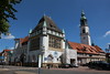
Museum for Local History, culture and art with good archeological section.
Schloßplatz 7
29221 Celle
49-(0)5141-12372
Tuesday-Sunday: 10:00 - 17:00
You may be viewing yesterday's version of this page. To see the most up to date information please register for a free account.
Do not use the above information on other web sites or publications without permission of the contributor.
Nearby Images from Flickr

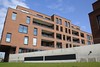
The above images may not be of the site on this page, but were taken nearby. They are loaded from Flickr so please click on them for image credits.
Click here to see more info for this site
Nearby sites
Click here to view sites on an interactive map of the areaKey: Red: member's photo, Blue: 3rd party photo, Yellow: other image, Green: no photo - please go there and take one, Grey: site destroyed
Download sites to:
KML (Google Earth)
GPX (GPS waypoints)
CSV (Garmin/Navman)
CSV (Excel)
To unlock full downloads you need to sign up as a Contributory Member. Otherwise downloads are limited to 50 sites.
Turn off the page maps and other distractions
Nearby sites listing. In the following links * = Image available
22.4km NNW 345° Wohlde Hügelgräberfeld* Barrow Cemetery
22.7km N 351° Siddernhausen Grosssteingrab* Chambered Tomb
26.7km N 358° Bonstorf Graeberfeld* Barrow Cemetery
27.3km NW 316° Siebensteinhäuser (Grab A)* Chambered Tomb
27.3km NW 316° Siebensteinhäuser (Grab D)* Chambered Tomb
27.4km NW 316° Siebensteinhäuser (Grab B)* Chambered Tomb
27.4km NW 316° Siebensteinhäuser (Grab C)* Chambered Tomb
27.4km NW 316° Siebensteinhäuser (Grab E)* Chambered Tomb
30.2km SSW 210° Urnengräberfeld Misburg* Barrow Cemetery
32.9km NE 42° Hoesseringen Museumsdorf* Museum
33.1km NE 42° Hoesseringen Steingrab (Lehmke)* Chambered Tomb
33.7km SW 219° Das Rad* Turf Maze
34.1km NW 306° Krelingen Steingrab* Chambered Tomb
34.2km SSW 214° Heiligers Brunnen* Holy Well or Sacred Spring
34.3km SSW 214° Kopperloch* Holy Well or Sacred Spring
36.8km SW 219° Niedersächsischen Landesmuseums Hannover* Museum
36.8km SW 219° Anderlingen Steinkistengrab (Hannover)* Chambered Tomb
37.1km NW 316° Megalithpark Osterberg* Sculptured Stone
37.7km NW 317° Museum Archaeologische Arbeitsgemeinschaft e.V* Museum
38.1km SSE 163° Gräwig Grabhügelfeld* Barrow Cemetery
38.8km S 169° Bueltener Holz Huegelgrabfeld* Barrow Cemetery
40.9km NNE 20° Eimke Steingrab* Chambered Tomb
41.8km NW 313° Hünenburg bei Bomlitz* Misc. Earthwork
41.9km S 171° Adenstedter Lah Hügelgräber* Barrow Cemetery
42.1km SW 225° Early Metalworking at the Benther Berg Ancient Mine, Quarry or other Industry
View more nearby sites and additional images


 We would like to know more about this location. Please feel free to add a brief description and any relevant information in your own language.
 Wir möchten mehr über diese Stätte erfahren. Bitte zögern Sie nicht, eine kurze Beschreibung und relevante Informationen in Deutsch hinzuzufügen.
 Nous aimerions en savoir encore un peu sur les lieux. S'il vous plaît n'hesitez pas à ajouter une courte description et tous les renseignements pertinents dans votre propre langue.
 Quisieramos informarnos un poco más de las lugares. No dude en añadir una breve descripción y otros datos relevantes en su propio idioma.