

<< Our Photo Pages >> Bredelem Grosssteingrab - Passage Grave in Germany in Lower Saxony, Bremen
Submitted by AlexHunger on Sunday, 11 September 2005 Page Views: 4768
Neolithic and Bronze AgeSite Name: Bredelem Grosssteingrab Alternative Name: Bredelem Steinkiste, Heidbrink Steinkammergrab, LangelsheimCountry: Germany
NOTE: This site is 2.494 km away from the location you searched for.
Land: Lower Saxony, Bremen Type: Passage Grave
Nearest Town: Braunschweig Nearest Village: Bredelem
Latitude: 51.959920N Longitude: 10.343090E
Condition:
| 5 | Perfect |
| 4 | Almost Perfect |
| 3 | Reasonable but with some damage |
| 2 | Ruined but still recognisable as an ancient site |
| 1 | Pretty much destroyed, possibly visible as crop marks |
| 0 | No data. |
| -1 | Completely destroyed |
| 5 | Superb |
| 4 | Good |
| 3 | Ordinary |
| 2 | Not Good |
| 1 | Awful |
| 0 | No data. |
| 5 | Can be driven to, probably with disabled access |
| 4 | Short walk on a footpath |
| 3 | Requiring a bit more of a walk |
| 2 | A long walk |
| 1 | In the middle of nowhere, a nightmare to find |
| 0 | No data. |
| 5 | co-ordinates taken by GPS or official recorded co-ordinates |
| 4 | co-ordinates scaled from a detailed map |
| 3 | co-ordinates scaled from a bad map |
| 2 | co-ordinates of the nearest village |
| 1 | co-ordinates of the nearest town |
| 0 | no data |
Internal Links:
External Links:
")
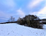
About 19 Meters long Allee Couverte with only 1 remaining 1.4 Meter tall upright. Most of the limestone uprights are about 50 cms tall. There are a few stray stones around the Allee Couverte, but all cap stones are gone. The site was excavated in 1959 and restored to some extend. It was dated to between 3500 and 2800 BCE. An other website suggests the passage grave never had capstones as no evidance of them has been found an that it may have had wooden beams for a roof instead, meaning it was built by a different culture than the other famous passage graves such as Lübensteine and Gross Steinum. There is a slightly shortened near full scale model in the Braunschweigisches Museum in Wolfenbütel, which suggests the upright was an altar and which includes the wooden roof and an embrionic tumulus. A further unauthenticated 2.5 Meter tall Menhir stands fenced off at the front of a nearby farm. In fields near Bredelem in Niedersachsen, Germany.
You may be viewing yesterday's version of this page. To see the most up to date information please register for a free account.
")
")
")
")
")
")
")
")
Do not use the above information on other web sites or publications without permission of the contributor.
Click here to see more info for this site
Nearby sites
Click here to view sites on an interactive map of the areaKey: Red: member's photo, Blue: 3rd party photo, Yellow: other image, Green: no photo - please go there and take one, Grey: site destroyed
Download sites to:
KML (Google Earth)
GPX (GPS waypoints)
CSV (Garmin/Navman)
CSV (Excel)
To unlock full downloads you need to sign up as a Contributory Member. Otherwise downloads are limited to 50 sites.
Turn off the page maps and other distractions
Nearby sites listing. In the following links * = Image available
876m NNE 28° Bredelem Menhir* Standing Stone (Menhir)
8.6km NE 40° Scheibenkreuzstein Liebenburg* Early Christian Sculptured Stone
8.8km SE 127° Klusfelsen (Goslar)* Rock Outcrop
9.0km NNW 326° Steinkreuz Sehlde Ancient Cross
11.8km NW 312° Hubertuskapelle* Cave or Rock Shelter
14.0km SE 137° Kästeklippen* Rock Outcrop
17.2km SSW 206° Hübichstein* Rock Outcrop
19.6km ENE 67° Summstein Hornburg* Modern Stone Circle etc
21.3km SW 228° Infogebäude am römisch-germansichen Schlachtfeld Museum
25.9km S 170° Hanskühnenburg-Klippe* Rock Outcrop
26.4km NNE 30° Braunschweigisches Landesmuseum* Museum
27.6km W 267° Apenteichquellen* Holy Well or Sacred Spring
27.8km SSE 155° Dreibrodesteine* Natural Stone / Erratic / Other Natural Feature
28.5km NE 53° Remlingen Totenhütte* Chambered Tomb
28.5km E 100° Brotstein* Standing Stone (Menhir)
28.6km S 187° Teufelsloch Osterode* Holy Well or Sacred Spring
28.6km SSW 204° Lichtensteinhöhle* Cave or Rock Shelter
29.7km SE 140° Hexentreppe Wurmberg* Ancient Trackway
29.8km ESE 114° Altenrode* Stone Circle
30.0km SE 145° Jemerstein* Rock Outcrop
31.0km NE 55° Meescheberg* Artificial Mound
31.0km S 189° Jettenhöhle* Cave or Rock Shelter
31.4km NE 54° Klein Vahlberg Menhir* Standing Stone (Menhir)
31.7km NE 54° Galgenberg von Klein Vahlberg* Artificial Mound
31.8km NW 315° Glockenstein* Standing Stone (Menhir)
View more nearby sites and additional images


 We would like to know more about this location. Please feel free to add a brief description and any relevant information in your own language.
 Wir möchten mehr über diese Stätte erfahren. Bitte zögern Sie nicht, eine kurze Beschreibung und relevante Informationen in Deutsch hinzuzufügen.
 Nous aimerions en savoir encore un peu sur les lieux. S'il vous plaît n'hesitez pas à ajouter une courte description et tous les renseignements pertinents dans votre propre langue.
 Quisieramos informarnos un poco más de las lugares. No dude en añadir una breve descripción y otros datos relevantes en su propio idioma.