


<< Text Pages >> Piane alla Sughera - Chambered Tomb in Italy in Toscana
Submitted by davidmorgan on Saturday, 20 September 2014 Page Views: 1102
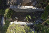
Neolithic and Bronze AgeSite Name: Piane alla SugheraCountry: Italy
NOTE: This site is 46.986 km away from the location you searched for.
Region: Toscana Type: Chambered Tomb
Nearest Village: Fetovaia
Latitude: 42.740343N Longitude: 10.159237E
Condition:
| 5 | Perfect |
| 4 | Almost Perfect |
| 3 | Reasonable but with some damage |
| 2 | Ruined but still recognisable as an ancient site |
| 1 | Pretty much destroyed, possibly visible as crop marks |
| 0 | No data. |
| -1 | Completely destroyed |
| 5 | Superb |
| 4 | Good |
| 3 | Ordinary |
| 2 | Not Good |
| 1 | Awful |
| 0 | No data. |
| 5 | Can be driven to, probably with disabled access |
| 4 | Short walk on a footpath |
| 3 | Requiring a bit more of a walk |
| 2 | A long walk |
| 1 | In the middle of nowhere, a nightmare to find |
| 0 | No data. |
| 5 | co-ordinates taken by GPS or official recorded co-ordinates |
| 4 | co-ordinates scaled from a detailed map |
| 3 | co-ordinates scaled from a bad map |
| 2 | co-ordinates of the nearest village |
| 1 | co-ordinates of the nearest town |
| 0 | no data |
Internal Links:
External Links:
Chambered Tomb in Elba, Toscana
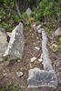
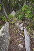
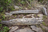
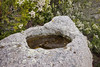
A Neolithic necropolis possibly related to the Arzachena-Ozieri culture of Sardinia.
You may be viewing yesterday's version of this page. To see the most up to date information please register for a free account.
Do not use the above information on other web sites or publications without permission of the contributor.
Nearby Images from Flickr

The above images may not be of the site on this page, but were taken nearby. They are loaded from Flickr so please click on them for image credits.
Click here to see more info for this site
Nearby sites
Click here to view sites on an interactive map of the areaKey: Red: member's photo, Blue: 3rd party photo, Yellow: other image, Green: no photo - please go there and take one, Grey: site destroyed
Download sites to:
KML (Google Earth)
GPX (GPS waypoints)
CSV (Garmin/Navman)
CSV (Excel)
To unlock full downloads you need to sign up as a Contributory Member. Otherwise downloads are limited to 50 sites.
Turn off the page maps and other distractions
Nearby sites listing. In the following links * = Image available
3.1km ENE 76° Sassiritti Standing Stone (Menhir)
39.7km NE 46° Populonia Necropolis* Rock Cut Tomb
64.5km W 265° U Nativu statue-menhir 2 Sculptured Stone
64.8km WNW 295° I Stanti a Rogliano stone circle Stone Circle
65.3km W 266° U Nativu statue-menhir* Sculptured Stone
65.6km WNW 284° Pinzu a Vergine alignment* Stone Row / Alignment
65.9km W 274° Grotta Scritta Rock Art
67.7km ENE 79° Vetulonia Mura dell' Arce* Ancient Village or Settlement
69.8km ENE 77° Tomba del Diavolino 2* Chambered Cairn
72.1km WSW 257° E Laure Burial Chamber or Dolmen
73.2km WSW 256° Murtola menhir Sculptured Stone
73.3km WSW 256° Murello menhir* Sculptured Stone
73.3km WSW 256° Plan di Natu coffres Burial Chamber or Dolmen
73.4km WSW 256° Buccentone menhir Sculptured Stone
73.4km WSW 256° Murello coffre Burial Chamber or Dolmen
73.4km WSW 256° Piève statues-menhirs* Sculptured Stone
73.5km W 264° Dolmen de la Casa di l'Urca Burial Chamber or Dolmen
73.7km W 264° Village Néolithique de Cima di Suarelle Ancient Village or Settlement
73.8km W 264° Menhir de Celluccia Standing Stone (Menhir)
73.9km W 264° Dolmen de Celluccia Burial Chamber or Dolmen
74.0km W 264° Dolmen de la Casa di l'Urcu* Burial Chamber or Dolmen
74.0km W 264° Cists de la Casa di l'Urcu Cist
74.0km W 264° Casa di l'Urcu Alignement Stone Row / Alignment
74.0km W 264° Monte Revincu stone circle Stone Circle
74.4km WSW 247° Campu di Buono coffres Burial Chamber or Dolmen
View more nearby sites and additional images


 We would like to know more about this location. Please feel free to add a brief description and any relevant information in your own language.
 Wir möchten mehr über diese Stätte erfahren. Bitte zögern Sie nicht, eine kurze Beschreibung und relevante Informationen in Deutsch hinzuzufügen.
 Nous aimerions en savoir encore un peu sur les lieux. S'il vous plaît n'hesitez pas à ajouter une courte description et tous les renseignements pertinents dans votre propre langue.
 Quisieramos informarnos un poco más de las lugares. No dude en añadir una breve descripción y otros datos relevantes en su propio idioma.