


<< Text Pages >> Celts' spa - Museum in Germany in Thuringia
Submitted by Klingon on Saturday, 22 July 2006 Page Views: 3169
MuseumsSite Name: Celts' spa Alternative Name: KeltenbadCountry: Germany
NOTE: This site is 3.968 km away from the location you searched for.
Land: Thuringia Type: Museum
Nearest Town: Bad Salzungen
Latitude: 50.816600N Longitude: 10.233300E
Condition:
| 5 | Perfect |
| 4 | Almost Perfect |
| 3 | Reasonable but with some damage |
| 2 | Ruined but still recognisable as an ancient site |
| 1 | Pretty much destroyed, possibly visible as crop marks |
| 0 | No data. |
| -1 | Completely destroyed |
| 5 | Superb |
| 4 | Good |
| 3 | Ordinary |
| 2 | Not Good |
| 1 | Awful |
| 0 | No data. |
| 5 | Can be driven to, probably with disabled access |
| 4 | Short walk on a footpath |
| 3 | Requiring a bit more of a walk |
| 2 | A long walk |
| 1 | In the middle of nowhere, a nightmare to find |
| 0 | No data. |
| 5 | co-ordinates taken by GPS or official recorded co-ordinates |
| 4 | co-ordinates scaled from a detailed map |
| 3 | co-ordinates scaled from a bad map |
| 2 | co-ordinates of the nearest village |
| 1 | co-ordinates of the nearest town |
| 0 | no data |
Be the first person to rate this site - see the 'Contribute!' box in the right hand menu.
Internal Links:
External Links:
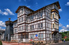
Museum in Thuringia
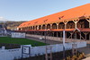
This spa isn't a museum, it's just a reminder to the tribes who lived in this area. Several features of the spa 've got Celtic names and in the wellness area you can have treatments like "Druids special therapy" (you will be joyfully whipped with herbs
homepage of the spa
You may be viewing yesterday's version of this page. To see the most up to date information please register for a free account.
Do not use the above information on other web sites or publications without permission of the contributor.
Nearby Images from Flickr
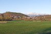
The above images may not be of the site on this page, but were taken nearby. They are loaded from Flickr so please click on them for image credits.
Click here to see more info for this site
Nearby sites
Click here to view sites on an interactive map of the areaKey: Red: member's photo, Blue: 3rd party photo, Yellow: other image, Green: no photo - please go there and take one, Grey: site destroyed
Download sites to:
KML (Google Earth)
GPX (GPS waypoints)
CSV (Garmin/Navman)
CSV (Excel)
To unlock full downloads you need to sign up as a Contributory Member. Otherwise downloads are limited to 50 sites.
Turn off the page maps and other distractions
Nearby sites listing. In the following links * = Image available
6.8km ENE 66° Schweina Barrow Cemetery
7.8km SSW 198° Langenfeld Artificial Mound
9.2km S 191° Bernshausen Artificial Mound
10.3km W 263° Dietlas Barrow Cemetery
10.8km WSW 236° Bornkopf Barrow Cemetery
10.8km SW 231° Dorniges Gehege Barrow Cemetery
11.0km SW 232° An der Kuhhalle Artificial Mound
11.3km SW 227° Bayershof Artificial Mound
12.0km SW 229° Baier Hillfort
12.6km WSW 248° Martinroda Barrow Cemetery
13.4km WSW 256° Völkershausen (1)* Artificial Mound
13.5km WSW 254° Völkershausen (2) Artificial Mound
13.8km W 267° Mönchsholz Barrow Cemetery
14.2km SW 228° Oechsen Artificial Mound
14.2km W 262° Sünnaer Weg Barrow Cemetery
14.4km WSW 253° Geiskopf Ancient Village or Settlement
14.8km W 262° Öchsenberg Causewayed Enclosure
15.2km SW 230° Bilstein Mound Artificial Mound
15.8km SW 225° Hessenkuppe Hillfort
15.9km WSW 254° Deicheroda Barrow Cemetery
16.6km NE 43° Flußbetthöhle Farnroda Cave or Rock Shelter
16.7km WSW 243° Arzberg Causewayed Enclosure
16.9km NW 316° Becks Grab Artificial Mound
17.0km NNE 18° Eisenacher Burg Ancient Village or Settlement
18.0km SSW 194° Fischbach Artificial Mound
View more nearby sites and additional images


 We would like to know more about this location. Please feel free to add a brief description and any relevant information in your own language.
 Wir möchten mehr über diese Stätte erfahren. Bitte zögern Sie nicht, eine kurze Beschreibung und relevante Informationen in Deutsch hinzuzufügen.
 Nous aimerions en savoir encore un peu sur les lieux. S'il vous plaît n'hesitez pas à ajouter une courte description et tous les renseignements pertinents dans votre propre langue.
 Quisieramos informarnos un poco más de las lugares. No dude en añadir una breve descripción y otros datos relevantes en su propio idioma.