


<< Our Photo Pages >> Utica Punic Tombs - Chambered Tomb in Tunisia
Submitted by AlexHunger on Sunday, 30 March 2008 Page Views: 4113
Neolithic and Bronze AgeSite Name: Utica Punic Tombs Alternative Name: UtiqueCountry: Tunisia Type: Chambered Tomb
Nearest Town: Tunis Nearest Village: El Kantara
Latitude: 37.057930N Longitude: 10.063070E
Condition:
| 5 | Perfect |
| 4 | Almost Perfect |
| 3 | Reasonable but with some damage |
| 2 | Ruined but still recognisable as an ancient site |
| 1 | Pretty much destroyed, possibly visible as crop marks |
| 0 | No data. |
| -1 | Completely destroyed |
| 5 | Superb |
| 4 | Good |
| 3 | Ordinary |
| 2 | Not Good |
| 1 | Awful |
| 0 | No data. |
| 5 | Can be driven to, probably with disabled access |
| 4 | Short walk on a footpath |
| 3 | Requiring a bit more of a walk |
| 2 | A long walk |
| 1 | In the middle of nowhere, a nightmare to find |
| 0 | No data. |
| 5 | co-ordinates taken by GPS or official recorded co-ordinates |
| 4 | co-ordinates scaled from a detailed map |
| 3 | co-ordinates scaled from a bad map |
| 2 | co-ordinates of the nearest village |
| 1 | co-ordinates of the nearest town |
| 0 | no data |
Internal Links:
External Links:
")
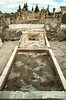
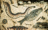
Punic Utica survived Roman conquest and by siding against Carthage, it's long time rival. Utica had been a Phoenician Colony about 2-300 years longer than carthage.
Due to creeping romanization, the original punic remains are about 2 meters beneath the Roman level.
There are several Punic sarcophogi and some Punic wall.
You may be viewing yesterday's version of this page. To see the most up to date information please register for a free account.
")
")
")
")
Do not use the above information on other web sites or publications without permission of the contributor.
Nearby Images from Flickr
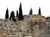
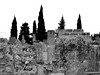
The above images may not be of the site on this page, but were taken nearby. They are loaded from Flickr so please click on them for image credits.
Click here to see more info for this site
Nearby sites
Click here to view sites on an interactive map of the areaKey: Red: member's photo, Blue: 3rd party photo, Yellow: other image, Green: no photo - please go there and take one, Grey: site destroyed
Download sites to:
KML (Google Earth)
GPX (GPS waypoints)
CSV (Garmin/Navman)
CSV (Excel)
To unlock full downloads you need to sign up as a Contributory Member. Otherwise downloads are limited to 50 sites.
Turn off the page maps and other distractions
Nearby sites listing. In the following links * = Image available
776m SSW 213° Utica Museum* Museum
790m SW 220° Utica* Ancient Village or Settlement
28.2km SSE 167° Musee du Bardo* Museum
32.3km SE 133° Carthage Temple of Saturn* Ancient Village or Settlement
32.5km SE 134° Carthage Byrsa* Ancient Village or Settlement
32.9km SE 133° Carthage Punic Tomb 1* Rock Cut Tomb
32.9km SE 133° Carthage Punic Tomb 2* Barrow Cemetery
33.0km SE 133° Carthage Punic Tomb 3* Barrow Cemetery
33.1km SE 134° Carthage Magon Quarter* Ancient Village or Settlement
33.2km SE 135° Carthage Punic Port* Ancient Mine, Quarry or other Industry
33.3km SE 136° Carthage Tophet* Ancient Temple
74.2km S 191° Thuburbo Majus* Ancient Village or Settlement
82.8km E 90° El Houaria Quarry* Ancient Mine, Quarry or other Industry
83.9km SW 229° Thiganica Ancient Village or Settlement
86.1km SSE 149° Pupput* Ancient Village or Settlement
89.6km ESE 105° El Harouri Necropolis Rock Cut Tomb
90.2km SE 139° Neapolis (Nabeul)* Ancient Village or Settlement
90.2km SE 140° Nabeul Museum Museum
92.3km E 97° Arg el-Ghazouni Necropolis Rock Cut Tomb
92.8km E 97° Kerkouane Museum* Museum
93.0km E 97° Kerkouane* Ancient Village or Settlement
95.6km NW 322° Museum Municipal Tavira/ Palace Galeria* Museum
96.5km ESE 104° Cloupia* Ancient Village or Settlement
96.7km ESE 104° Kelibia Fortress* Hillfort
98.4km SW 228° Teboursukum* Ancient Village or Settlement
View more nearby sites and additional images


 We would like to know more about this location. Please feel free to add a brief description and any relevant information in your own language.
 Wir möchten mehr über diese Stätte erfahren. Bitte zögern Sie nicht, eine kurze Beschreibung und relevante Informationen in Deutsch hinzuzufügen.
 Nous aimerions en savoir encore un peu sur les lieux. S'il vous plaît n'hesitez pas à ajouter une courte description et tous les renseignements pertinents dans votre propre langue.
 Quisieramos informarnos un poco más de las lugares. No dude en añadir una breve descripción y otros datos relevantes en su propio idioma.