


<< Our Photo Pages >> Pierre Levée (Liniez) - Passage Grave in France in Centre:Indre (36)
Submitted by TheCaptain on Friday, 16 January 2009 Page Views: 5592
Neolithic and Bronze AgeSite Name: Pierre Levée (Liniez) Alternative Name: Liniez Allée couverteCountry: France
NOTE: This site is 11.671 km away from the location you searched for.
Département: Centre:Indre (36) Type: Passage Grave
Nearest Town: Chateauroux Nearest Village: Liniez
Latitude: 47.027600N Longitude: 1.758500E
Condition:
| 5 | Perfect |
| 4 | Almost Perfect |
| 3 | Reasonable but with some damage |
| 2 | Ruined but still recognisable as an ancient site |
| 1 | Pretty much destroyed, possibly visible as crop marks |
| 0 | No data. |
| -1 | Completely destroyed |
| 5 | Superb |
| 4 | Good |
| 3 | Ordinary |
| 2 | Not Good |
| 1 | Awful |
| 0 | No data. |
| 5 | Can be driven to, probably with disabled access |
| 4 | Short walk on a footpath |
| 3 | Requiring a bit more of a walk |
| 2 | A long walk |
| 1 | In the middle of nowhere, a nightmare to find |
| 0 | No data. |
| 5 | co-ordinates taken by GPS or official recorded co-ordinates |
| 4 | co-ordinates scaled from a detailed map |
| 3 | co-ordinates scaled from a bad map |
| 2 | co-ordinates of the nearest village |
| 1 | co-ordinates of the nearest town |
| 0 | no data |
Internal Links:
External Links:
I have visited· I would like to visit
SolarMegalith DrewParsons would like to visit
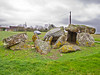
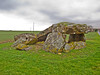
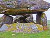
TheCaptain visited on 27th Sep 2005 - their rating: Cond: 4 Amb: 3 Access: 5 Just outside the village of Liniez, along the D.926 road towards Vatan, and to the right of the road can be seen the remains of this allée couverte. It was probably an Angevin type allée couverte, but there are no obvious remains of the porchway. The remains of the chamber are 10 metres long by 4 metres wide, and it was probably covered by four capstones, of which three remain in various positions, from still in place at the back end, sloping in the middle and flat on the ground at the front. Several side slabs remain, as does the backslab, and there is evidence of a possible internal partition, although it could be bits of broken capstone. The back cell of the chamber is still all nicely erect, making this a pleasant monument to visit. It is all orientated towards the east at 070°.
johnstone visited on 5th Jul 1998 - their rating: Cond: 4 Amb: 3 Access: 5
Average ratings for this site from all visit loggers: Condition: 4 Ambience: 3 Access: 5
 (PID:44883)")
The remains of the chamber are 10 metres long by 4 metres wide, and it was probably covered by four capstones, of which three remain in various positions, from still in place at the back end, sloping in the middle and flat on the ground at the front.
Several side slabs remain, as does the backslab, and there is evidence of a possible internal partition, although it could be bits of broken capstone. The back cell of the chamber is still all nicely erect, making this a pleasant monument to visit. It is all orientated towards the east at 070°.
Base Mérimée (Historic Monument)
IMPORTANT NOTE: Positional co-ordinates taken from a gps receiver.
You may be viewing yesterday's version of this page. To see the most up to date information please register for a free account.
 (PID:44882)")
 (PID:44881)")
 (PID:44880)")
 (PID:44879)")
Do not use the above information on other web sites or publications without permission of the contributor.
Nearby Images from Flickr
The above images may not be of the site on this page, but were taken nearby. They are loaded from Flickr so please click on them for image credits.
Click here to see more info for this site
Nearby sites
Click here to view sites on an interactive map of the areaKey: Red: member's photo, Blue: 3rd party photo, Yellow: other image, Green: no photo - please go there and take one, Grey: site destroyed
Download sites to:
KML (Google Earth)
GPX (GPS waypoints)
CSV (Garmin/Navman)
CSV (Excel)
To unlock full downloads you need to sign up as a Contributory Member. Otherwise downloads are limited to 50 sites.
Turn off the page maps and other distractions
Nearby sites listing. In the following links * = Image available
1.1km NNE 28° Liniez Tumulus elliptique Chambered Tomb
5.2km WNW 293° Dolmen des Pierres Folles (Bouges-le-Château) Burial Chamber or Dolmen
14.1km NE 56° Dolmen de l'Ormeau Burial Chamber or Dolmen
14.3km ENE 63° Dolmen de la Pierre-Folle (Le Creuset)* Burial Chamber or Dolmen
15.0km NE 37° La Pierre Levée (Graçay)* Burial Chamber or Dolmen
15.1km W 264° Les Chateliers Ancient Village or Settlement
16.2km N 1° Tréfoux deux menhirs* Standing Stones
16.7km WSW 258° La Pierre cromlech Stone Circle
16.7km N 3° Pierre Couverte de Bué* Burial Chamber or Dolmen
16.8km WSW 258° La Pierre Dolmen* Burial Chamber or Dolmen
17.4km N 4° Pierre Levée de Boisy Standing Stone (Menhir)
30.2km NNW 331° Prieuré Saint Eusice dolmen Burial Chamber or Dolmen
33.7km WSW 252° Saint-Genou Polissoir* Polissoir
34.1km NW 324° Dolmen de Châtillon-sur-Cher Burial Chamber or Dolmen
36.5km E 93° Dolmen dit la Table (Parneaux) Burial Chamber or Dolmen
36.8km N 359° Musée Archéologique Marcel de Marchéville Museum
38.2km WSW 238° La Pierre Saint-Martin* Burial Chamber or Dolmen
38.6km NW 316° La Pierre-Frite de Grandmont Standing Stone (Menhir)
39.2km WSW 242° Menhir dit la Bobinette du Diable Standing Stone (Menhir)
39.2km WSW 242° Dolmen dit la Pierre Levée (Saulnay) Burial Chamber or Dolmen
46.1km W 266° Menhir des Gambades Standing Stone (Menhir)
46.3km NNW 338° Tertre tumulus Chambered Tomb
46.3km NNW 338° Les Montanjons tumuli Chambered Tomb
46.6km SW 218° Dolmen de la Pierre Levée (La Guignerie) Burial Chamber or Dolmen
47.5km SSW 196° Dolmen des Thibauds* Burial Chamber or Dolmen
View more nearby sites and additional images


 We would like to know more about this location. Please feel free to add a brief description and any relevant information in your own language.
 Wir möchten mehr über diese Stätte erfahren. Bitte zögern Sie nicht, eine kurze Beschreibung und relevante Informationen in Deutsch hinzuzufügen.
 Nous aimerions en savoir encore un peu sur les lieux. S'il vous plaît n'hesitez pas à ajouter une courte description et tous les renseignements pertinents dans votre propre langue.
 Quisieramos informarnos un poco más de las lugares. No dude en añadir una breve descripción y otros datos relevantes en su propio idioma.