

<< Our Photo Pages >> Menhir des Rivals - Standing Stone (Menhir) in France in Midi:Tarn (81)
Submitted by LaDragonne on Thursday, 28 December 2017 Page Views: 1196
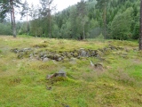
Neolithic and Bronze AgeSite Name: Menhir des Rivals Alternative Name: Menhir de La Rode; menhir de LagardiolleCountry: France
NOTE: This site is 28.97 km away from the location you searched for.
Département: Midi:Tarn (81) Type: Standing Stone (Menhir)
Nearest Town: Castres Nearest Village: Lagardiolle
Latitude: 43.512000N Longitude: 2.092750E
Condition:
| 5 | Perfect |
| 4 | Almost Perfect |
| 3 | Reasonable but with some damage |
| 2 | Ruined but still recognisable as an ancient site |
| 1 | Pretty much destroyed, possibly visible as crop marks |
| 0 | No data. |
| -1 | Completely destroyed |
| 5 | Superb |
| 4 | Good |
| 3 | Ordinary |
| 2 | Not Good |
| 1 | Awful |
| 0 | No data. |
| 5 | Can be driven to, probably with disabled access |
| 4 | Short walk on a footpath |
| 3 | Requiring a bit more of a walk |
| 2 | A long walk |
| 1 | In the middle of nowhere, a nightmare to find |
| 0 | No data. |
| 5 | co-ordinates taken by GPS or official recorded co-ordinates |
| 4 | co-ordinates scaled from a detailed map |
| 3 | co-ordinates scaled from a bad map |
| 2 | co-ordinates of the nearest village |
| 1 | co-ordinates of the nearest town |
| 0 | no data |
Internal Links:
External Links:
I have visited· I would like to visit
johnstone visited on 13th Sep 2018 - their rating: Cond: 4 Amb: 4 Access: 5
")
It shows several cups and grooves on its north face, a few on the south face. A deeply carved groove runs over both faces.
It has been "Christianized" by engraving a cross on the south side
May be slightly inclined compared to its original position.
Original description by LaDragonne: Joli menhir situé non loin du château de la Rode et du hameau des Rivals , sur la commune de Lagardiolle, sur la limite de commune Lagardiolle / Lempaut. 1m50 de haut, 1m10 de large et 20cm d'épaisseur. Présente de nombreuses cupules et rainures sur sa face nord, quelques unes sur la face sud. Une rainure particulièrement marquée concerne les deux faces.
A été "christianisé" grossièrement (gravure d'une croix sur la face sud)
Est peut-être légèrement incliné par rapport à son érection initiale.
You may be viewing yesterday's version of this page. To see the most up to date information please register for a free account.
")
")
")
")
Do not use the above information on other web sites or publications without permission of the contributor.
Nearby Images from Flickr
The above images may not be of the site on this page, but were taken nearby. They are loaded from Flickr so please click on them for image credits.
Click here to see more info for this site
Nearby sites
Click here to view sites on an interactive map of the areaKey: Red: member's photo, Blue: 3rd party photo, Yellow: other image, Green: no photo - please go there and take one, Grey: site destroyed
Download sites to:
KML (Google Earth)
GPX (GPS waypoints)
CSV (Garmin/Navman)
CSV (Excel)
To unlock full downloads you need to sign up as a Contributory Member. Otherwise downloads are limited to 50 sites.
Turn off the page maps and other distractions
Nearby sites listing. In the following links * = Image available
5.9km SW 228° Menhirs des Lattes* Standing Stones
7.4km S 183° Grotte du Calel* Cave or Rock Shelter
7.9km S 191° Berniquaut Oppidum Ancient Village or Settlement
8.4km S 187° Peyre-Ficade la Privade * Standing Stone (Menhir)
8.6km S 184° Menhir de Jacournassy* Standing Stone (Menhir)
10.4km SSW 204° Menhir de Peyre Basal* Standing Stone (Menhir)
10.6km ENE 64° La Pierre Plantée (Les Bels)* Modern Stone Circle etc
13.3km S 169° Menhir Bois de l'Alquier Nord* Standing Stone (Menhir)
14.2km ENE 77° Pisse Lièvre tumulus Chambered Tomb
16.3km SSE 160° Pierre levée de Picarel* Standing Stone (Menhir)
18.4km E 101° Dolmen de Récuquelle 1* Natural Stone / Erratic / Other Natural Feature
18.6km E 101° Dolmen de Recuquelle 2* Natural Stone / Erratic / Other Natural Feature
19.1km E 94° Grotte de Lacalm* Cave or Rock Shelter
22.0km ENE 59° Roc de Baptistou* Rock Outcrop
22.1km ENE 59° Chaos de la Rouquette* Rock Outcrop
22.2km ENE 59° Rocher Le Sabot de la Rouquette* Rock Outcrop
22.2km ENE 59° Rocher tremblant de la Rouquette (l'Oeuf)* Rock Outcrop
22.8km NE 53° Le Grain de Campsoleil* Rock Art
23.0km ENE 64° Roc de Ruscayrolles Rock Outcrop
24.1km E 101° Pierre Plantée d'Hautpoul* Standing Stone (Menhir)
24.7km ENE 62° Rocher Tremblant de Lascombes* Rock Outcrop
25.3km ESE 123° Dolmens de la Cahusière Burial Chamber or Dolmen
25.6km NE 55° Le Roc du Verdier* Rock Outcrop
25.7km ENE 71° Statue-menhir du Vergnas* Sculptured Stone
26.2km SSE 158° Menhir de Guitard Standing Stone (Menhir)
View more nearby sites and additional images


 We would like to know more about this location. Please feel free to add a brief description and any relevant information in your own language.
 Wir möchten mehr über diese Stätte erfahren. Bitte zögern Sie nicht, eine kurze Beschreibung und relevante Informationen in Deutsch hinzuzufügen.
 Nous aimerions en savoir encore un peu sur les lieux. S'il vous plaît n'hesitez pas à ajouter une courte description et tous les renseignements pertinents dans votre propre langue.
 Quisieramos informarnos un poco más de las lugares. No dude en añadir una breve descripción y otros datos relevantes en su propio idioma.