
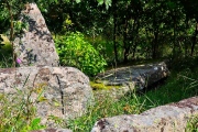

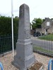
<< Our Photo Pages >> Menhir du Fayel - Standing Stone (Menhir) in France in Picardie:Oise (60)
Submitted by AlexHunger on Thursday, 10 February 2005 Page Views: 4216
Neolithic and Bronze AgeSite Name: Menhir du Fayel Alternative Name: Pierre FriteCountry: France Département: Picardie:Oise (60) Type: Standing Stone (Menhir)
Nearest Town: Gisors Nearest Village: Boubiers
Latitude: 49.205600N Longitude: 1.851300E
Condition:
| 5 | Perfect |
| 4 | Almost Perfect |
| 3 | Reasonable but with some damage |
| 2 | Ruined but still recognisable as an ancient site |
| 1 | Pretty much destroyed, possibly visible as crop marks |
| 0 | No data. |
| -1 | Completely destroyed |
| 5 | Superb |
| 4 | Good |
| 3 | Ordinary |
| 2 | Not Good |
| 1 | Awful |
| 0 | No data. |
| 5 | Can be driven to, probably with disabled access |
| 4 | Short walk on a footpath |
| 3 | Requiring a bit more of a walk |
| 2 | A long walk |
| 1 | In the middle of nowhere, a nightmare to find |
| 0 | No data. |
| 5 | co-ordinates taken by GPS or official recorded co-ordinates |
| 4 | co-ordinates scaled from a detailed map |
| 3 | co-ordinates scaled from a bad map |
| 2 | co-ordinates of the nearest village |
| 1 | co-ordinates of the nearest town |
| 0 | no data |
Internal Links:
External Links:
")
1.35 Meters tall, 2 Km Soth West of town, 500 Meters West of Fayel, on cote 121, at lieu-dit "la Pierre-Frite".
Wikipedia article
Sites mégalithiques de l'Oise
Note: Positional co-ordinates scaled from a detailed map source.
You may be viewing yesterday's version of this page. To see the most up to date information please register for a free account.
Do not use the above information on other web sites or publications without permission of the contributor.
Nearby Images from Flickr
The above images may not be of the site on this page, but were taken nearby. They are loaded from Flickr so please click on them for image credits.
Click here to see more info for this site
Nearby sites
Click here to view sites on an interactive map of the areaKey: Red: member's photo, Blue: 3rd party photo, Yellow: other image, Green: no photo - please go there and take one, Grey: site destroyed
Download sites to:
KML (Google Earth)
GPX (GPS waypoints)
CSV (Garmin/Navman)
CSV (Excel)
To unlock full downloads you need to sign up as a Contributory Member. Otherwise downloads are limited to 50 sites.
Turn off the page maps and other distractions
Nearby sites listing. In the following links * = Image available
5.2km S 179° Les Luats Passage Grave
5.8km N 2° Menhir dit la Pierre Droite (Delincourt)* Standing Stone (Menhir)
6.8km WNW 285° Allée Couverte de Vaudancourt Passage Grave
7.1km NNW 337° Chambors Menhir* Standing Stone (Menhir)
7.5km N 353° Trie-Château Menhir* Standing Stone (Menhir)
7.5km N 351° Trie-Chateau dolmen* Passage Grave
7.9km ESE 103° Pierre Frite de Lavilletertre* Standing Stone (Menhir)
8.0km NW 305° Menhir de la Bellée Standing Stone (Menhir)
8.1km NW 306° Allée couverte de la Bellée* Passage Grave
9.5km S 177° Menhir dit la Croisette* Standing Stone (Menhir)
9.8km S 183° Bois Couturier Allée couverte* Passage Grave
10.3km WNW 288° Pierres Tournantes Standing Stones
10.7km S 180° La Ferme Duport Passage Grave
10.8km S 181° Musée Archéologique Du Val-D'Oise* Museum
11.0km NW 315° Croix Percée* Ancient Cross
12.1km S 182° Menhir dit la Pierre Droite (Gadancourt)* Standing Stone (Menhir)
12.4km E 92° Pierre aux Coqs Standing Stone (Menhir)
12.4km W 267° Allée Couverte du Fayel Passage Grave
12.5km S 176° Polissoir de St Martin* Polissoir
12.7km E 89° Pierre Fritte de Neuville-Bosc* Standing Stone (Menhir)
13.0km WSW 249° Vielle Cote Dolmen* Passage Grave
15.0km WSW 257° Allée Couverte de Dampsmesnil* Passage Grave
17.5km N 352° Menhir dit la Borne du Bois Madame* Standing Stone (Menhir)
17.6km SSW 201° Drocourt Menhir Standing Stone (Menhir)
18.1km SW 228° Allée couverte de Bézu Passage Grave
View more nearby sites and additional images


 We would like to know more about this location. Please feel free to add a brief description and any relevant information in your own language.
 Wir möchten mehr über diese Stätte erfahren. Bitte zögern Sie nicht, eine kurze Beschreibung und relevante Informationen in Deutsch hinzuzufügen.
 Nous aimerions en savoir encore un peu sur les lieux. S'il vous plaît n'hesitez pas à ajouter une courte description et tous les renseignements pertinents dans votre propre langue.
 Quisieramos informarnos un poco más de las lugares. No dude en añadir una breve descripción y otros datos relevantes en su propio idioma.