 with our Megalithic Portal iPhone app")


<< Text Pages >> The Witches' Stones, Lowestoft - Modern Stone Circle etc in England in Suffolk
Submitted by willowman1 on Monday, 03 October 2016 Page Views: 5766
Modern SitesSite Name: The Witches' Stones, LowestoftCountry: England
NOTE: This site is 5.161 km away from the location you searched for.
County: Suffolk Type: Modern Stone Circle etc
Nearest Town: Lowestoft
Map Ref: TM5505294359
Latitude: 52.487471N Longitude: 1.755312E
Condition:
| 5 | Perfect |
| 4 | Almost Perfect |
| 3 | Reasonable but with some damage |
| 2 | Ruined but still recognisable as an ancient site |
| 1 | Pretty much destroyed, possibly visible as crop marks |
| 0 | No data. |
| -1 | Completely destroyed |
| 5 | Superb |
| 4 | Good |
| 3 | Ordinary |
| 2 | Not Good |
| 1 | Awful |
| 0 | No data. |
| 5 | Can be driven to, probably with disabled access |
| 4 | Short walk on a footpath |
| 3 | Requiring a bit more of a walk |
| 2 | A long walk |
| 1 | In the middle of nowhere, a nightmare to find |
| 0 | No data. |
| 5 | co-ordinates taken by GPS or official recorded co-ordinates |
| 4 | co-ordinates scaled from a detailed map |
| 3 | co-ordinates scaled from a bad map |
| 2 | co-ordinates of the nearest village |
| 1 | co-ordinates of the nearest town |
| 0 | no data |
Internal Links:
External Links:
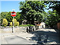
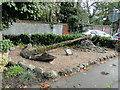
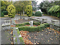
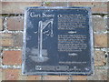
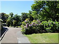
The Witches' Stones are a non-prehistoric 'cairn' of stones mortared together, now with an old anchor on top, just inside the southern entrance to Belle Vue Park. Once it was reckoned to be a forerunner to the town's lighthouse, but in fact the heap is what remains of a warning beacon built in 1550.
Another was located at the top of Green Score (now Links Road). Both had iron steps upon the stonework leading up to a platform, on which a fire of pitch and timber would be kindled, as signals in the event of imminent invasion. The area used to be called Beacon Hill, but by 1676 any threats had long since receded, and the beacon was mostly dismantled.
Local legend says that the Witches' Stones, unless bathed in fire, run down to the sea at the first stroke of midnight struck by the Town Hall clock, and are back in place by the last stroke. The stones were also said to be 'weather makers', in that if water was poured over them, it would cause rain.
The origin of the name is uncertain, but there was perhaps a connection with the town's two most famous witches, Amy (or Ann) Denny and Rose Cullender, who were hanged in 1662. One story alleges that Amy Denny was in the habit of sitting on the stones and hurling curses at passers-by - although this was never brought as evidence against her.
You may be viewing yesterday's version of this page. To see the most up to date information please register for a free account.
")
Do not use the above information on other web sites or publications without permission of the contributor.
Nearby Images from Geograph Britain and Ireland:
©2018(licence)
©2016(licence)
©2010(licence)
©2018(licence)
©2014(licence)
The above images may not be of the site on this page, they are loaded from Geograph.
Please Submit an Image of this site or go out and take one for us!
Click here to see more info for this site
Nearby sites
Key: Red: member's photo, Blue: 3rd party photo, Yellow: other image, Green: no photo - please go there and take one, Grey: site destroyed
Download sites to:
KML (Google Earth)
GPX (GPS waypoints)
CSV (Garmin/Navman)
CSV (Excel)
To unlock full downloads you need to sign up as a Contributory Member. Otherwise downloads are limited to 50 sites.
Turn off the page maps and other distractions
Nearby sites listing. In the following links * = Image available
9.5km NNW 347° Gull Stones (Great Yarmouth) Sculptured Stone (TG524035)
9.7km NW 316° Bell Hill Round Barrow(s) (TG480010)
9.7km NW 316° Mill Hill Round Barrow(s) (TG480010)
12.6km NW 326° Burgh Castle Shore Fort Stone Fort or Dun (TG474044)
16.4km W 274° Stockton Stone* Standing Stone (Menhir) (TM386946)
20.7km SSW 212° Ladywell (Blythborough)* Holy Well or Sacred Spring (TM450762)
20.8km W 265° Broome Heath Long Barrow Long Barrow (TM344913)
21.0km SSW 205° Walberswick Burial Mounds* Round Barrow(s) (TM4718274820)
21.8km W 261° Druid's Stone (Bungay)* Natural Stone / Erratic / Other Natural Feature (TM3366689739)
25.9km WSW 255° Flixton Park Quarry Timber Circle (TM303863)
33.1km WNW 294° Arminghall Henge* Henge (TG240060)
33.2km WNW 289° Venta Icenorum* Ancient Village or Settlement (TG230034)
34.8km WNW 297° Norwich Castle Museum and Art Gallery* Museum (TG231085)
34.9km W 276° Tasburgh Fort* Hillfort (TM201960)
35.6km WNW 292° Eaton Heath Barrow Cemetery (TG21280605)
36.9km NNW 330° Devil's Ditch Ancient Trackway (TG347252)
38.4km WSW 242° Kesgrave Bowl Barrow 2 Round Barrow(s) (TM220745)
40.2km SSW 203° Iken Saxon Cross* Ancient Cross (TM412566)
40.8km WSW 248° St. Edmund's Cross Ancient Cross (TM1877)
40.9km NNW 338° Happisburgh Ancient Village or Settlement (TG379315)
41.4km WNW 296° Roundwell* Holy Well or Sacred Spring (TG168104)
42.1km WNW 293° St Walstan's Well* Holy Well or Sacred Spring (TG15350878)
43.2km NW 306° Horsford Woods Barrow Cemetary* Barrow Cemetery (TG18571780)
44.9km WNW 282° St Thomas's Well (Wymondham)* Holy Well or Sacred Spring (TG10550146)
45.5km WSW 255° Diss Museum* Museum (TM1171179980)
View more nearby sites and additional images


 We would like to know more about this location. Please feel free to add a brief description and any relevant information in your own language.
 Wir möchten mehr über diese Stätte erfahren. Bitte zögern Sie nicht, eine kurze Beschreibung und relevante Informationen in Deutsch hinzuzufügen.
 Nous aimerions en savoir encore un peu sur les lieux. S'il vous plaît n'hesitez pas à ajouter une courte description et tous les renseignements pertinents dans votre propre langue.
 Quisieramos informarnos un poco más de las lugares. No dude en añadir una breve descripción y otros datos relevantes en su propio idioma.