


<< Our Photo Pages >> Walberswick Burial Mounds - Round Barrow(s) in England in Suffolk
Submitted by willowman1 on Friday, 30 September 2016 Page Views: 3067
Neolithic and Bronze AgeSite Name: Walberswick Burial MoundsCountry: England
NOTE: This site is 3.417 km away from the location you searched for.
County: Suffolk Type: Round Barrow(s)
Nearest Town: Walberswick
Map Ref: TM4718274820
Latitude: 52.315786N Longitude: 1.625235E
Condition:
| 5 | Perfect |
| 4 | Almost Perfect |
| 3 | Reasonable but with some damage |
| 2 | Ruined but still recognisable as an ancient site |
| 1 | Pretty much destroyed, possibly visible as crop marks |
| 0 | No data. |
| -1 | Completely destroyed |
| 5 | Superb |
| 4 | Good |
| 3 | Ordinary |
| 2 | Not Good |
| 1 | Awful |
| 0 | No data. |
| 5 | Can be driven to, probably with disabled access |
| 4 | Short walk on a footpath |
| 3 | Requiring a bit more of a walk |
| 2 | A long walk |
| 1 | In the middle of nowhere, a nightmare to find |
| 0 | No data. |
| 5 | co-ordinates taken by GPS or official recorded co-ordinates |
| 4 | co-ordinates scaled from a detailed map |
| 3 | co-ordinates scaled from a bad map |
| 2 | co-ordinates of the nearest village |
| 1 | co-ordinates of the nearest town |
| 0 | no data |
Internal Links:
External Links:
")
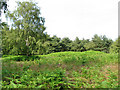
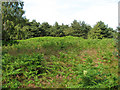
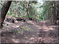
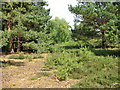
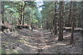
Two unexcavated round barrows stand on the heathland known as Tinkers Walks, beside the B1387 road from Blythburgh to Walberswick. One, at TM46997465, is 32m across but less than a metre high, and has been clipped by the road. The other is 21m across and 1.2m high, and it is from this mound that on certain moonlit nights, the ghostly 'Heath Horse' is said to emerge and gallop silently over the heath.
Although some have said the barrows are Bronze Age, their position on high ground overlooking an estuary has suggested to others that they might be Saxon, possibly even ship burials.
You may be viewing yesterday's version of this page. To see the most up to date information please register for a free account.
Do not use the above information on other web sites or publications without permission of the contributor.
Nearby Images from Geograph Britain and Ireland:
©2010(licence)
©2010(licence)
©2010(licence)
©2010(licence)
©2010(licence)
The above images may not be of the site on this page, they are loaded from Geograph.
Please Submit an Image of this site or go out and take one for us!
Click here to see more info for this site
Nearby sites
Key: Red: member's photo, Blue: 3rd party photo, Yellow: other image, Green: no photo - please go there and take one, Grey: site destroyed
Download sites to:
KML (Google Earth)
GPX (GPS waypoints)
CSV (Garmin/Navman)
CSV (Excel)
To unlock full downloads you need to sign up as a Contributory Member. Otherwise downloads are limited to 50 sites.
Turn off the page maps and other distractions
Nearby sites listing. In the following links * = Image available
2.6km NW 305° Ladywell (Blythborough)* Holy Well or Sacred Spring (TM450762)
19.2km SSW 201° Iken Saxon Cross* Ancient Cross (TM412566)
20.1km NW 321° Druid's Stone (Bungay)* Natural Stone / Erratic / Other Natural Feature (TM3366689739)
20.4km NW 307° Flixton Park Quarry Timber Circle (TM303863)
20.8km NW 325° Broome Heath Long Barrow Long Barrow (TM344913)
21.0km NNE 25° The Witches' Stones, Lowestoft Modern Stone Circle etc (TM5505294359)
21.5km NNW 339° Stockton Stone* Standing Stone (Menhir) (TM386946)
25.1km W 272° Kesgrave Bowl Barrow 2 Round Barrow(s) (TM220745)
26.2km N 5° Bell Hill Round Barrow(s) (TG480010)
26.2km N 5° Mill Hill Round Barrow(s) (TG480010)
29.1km NNE 13° Gull Stones (Great Yarmouth) Sculptured Stone (TG524035)
29.2km W 277° St. Edmund's Cross Ancient Cross (TM1877)
29.5km N 3° Burgh Castle Shore Fort Stone Fort or Dun (TG474044)
31.9km SW 218° Sutton Hoo* Artificial Mound (TM288487)
33.4km SSW 210° Shottisham Monument Complex Henge (TM32004505)
33.4km SW 231° Burgh Enclosure Ancient Village or Settlement (TM224523)
34.3km NW 311° Tasburgh Fort* Hillfort (TM201960)
35.7km W 281° Diss Museum* Museum (TM1171179980)
36.4km SW 223° Martlesham Heath* Round Barrow(s) (TM238468)
36.5km SW 219° Falcon Park Round Barrow(s) (TM25504534)
36.6km SW 221° Martlesham Airfield Round Barrow(s) (TM24224616)
37.0km SW 222° Martlesham Bowl Barrow 2* Round Barrow(s) (TM23874598)
37.1km SW 222° Martlesham Bowl Barrow 1* Round Barrow(s) (TM23864587)
37.4km NW 323° Venta Icenorum* Ancient Village or Settlement (TG230034)
37.4km SW 219° Sheep Drift Farm Round Barrow(s) (TM2495444591)
View more nearby sites and additional images


 We would like to know more about this location. Please feel free to add a brief description and any relevant information in your own language.
 Wir möchten mehr über diese Stätte erfahren. Bitte zögern Sie nicht, eine kurze Beschreibung und relevante Informationen in Deutsch hinzuzufügen.
 Nous aimerions en savoir encore un peu sur les lieux. S'il vous plaît n'hesitez pas à ajouter une courte description et tous les renseignements pertinents dans votre propre langue.
 Quisieramos informarnos un poco más de las lugares. No dude en añadir una breve descripción y otros datos relevantes en su propio idioma.