

<< Our Photo Pages >> Seven Hills - Barrow Cemetery in England in Suffolk
Submitted by JohnGinny on Saturday, 24 March 2012 Page Views: 17122
Neolithic and Bronze AgeSite Name: Seven HillsCountry: England
NOTE: This site is 0.278 km away from the location you searched for.
County: Suffolk Type: Barrow Cemetery
Map Ref: TM225413 Landranger Map Number: 169
Latitude: 52.025464N Longitude: 1.241805E
Condition:
| 5 | Perfect |
| 4 | Almost Perfect |
| 3 | Reasonable but with some damage |
| 2 | Ruined but still recognisable as an ancient site |
| 1 | Pretty much destroyed, possibly visible as crop marks |
| 0 | No data. |
| -1 | Completely destroyed |
| 5 | Superb |
| 4 | Good |
| 3 | Ordinary |
| 2 | Not Good |
| 1 | Awful |
| 0 | No data. |
| 5 | Can be driven to, probably with disabled access |
| 4 | Short walk on a footpath |
| 3 | Requiring a bit more of a walk |
| 2 | A long walk |
| 1 | In the middle of nowhere, a nightmare to find |
| 0 | No data. |
| 5 | co-ordinates taken by GPS or official recorded co-ordinates |
| 4 | co-ordinates scaled from a detailed map |
| 3 | co-ordinates scaled from a bad map |
| 2 | co-ordinates of the nearest village |
| 1 | co-ordinates of the nearest town |
| 0 | no data |
Internal Links:
External Links:
I have visited· I would like to visit
JohnLindsay visited on 6th Apr 2012 - their rating: Cond: 1 Amb: 3 Access: 4 Interesingly the crematorium is called Seven Hills. There seems to be quite a lot of continuity in places of death. The complexity of finding out any more is that the museum authority is Colchester and Ipswich, if you are in Ipswich. Then there is Suffolk Archaeology. And the Suffolk Record Office. In the Ipswich museum there is a map showing a mass of things around this Nacton site, but only for one age, the other maps are only of Ipswich.
In addition there is a suffolk institute of archaeology which produces proceedings so now to track all this down. The museum curator said start with suffolk archaeology
")
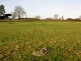
Barrow 2 (left) A well preserved and nicely shaped barrow. Just on the left before the railway bridge as you turn into Levington.
Most such barrow cemeteries developed over a long period of time, often many centuries, and in some cases acted as a focus for burials as late as the early medieval period.
They exhibit considerable diversity of burial rite, plan and form, frequently including different types of round barrow and, wherever large scale investigation beyond barrows has been undertaken, revealing contemporary or later 'flat' burials between the barrow mounds.
The Seven Hills cemetery is part of a larger group of round barrows and circular ditched enclosures which extend in a line to the south-east, over a distance of 3km, to Levington Heath.
You may be viewing yesterday's version of this page. To see the most up to date information please register for a free account.
")
")
")
")
")
Do not use the above information on other web sites or publications without permission of the contributor.
Click here to see more info for this site
Nearby sites
Key: Red: member's photo, Blue: 3rd party photo, Yellow: other image, Green: no photo - please go there and take one, Grey: site destroyed
Download sites to:
KML (Google Earth)
GPX (GPS waypoints)
CSV (Garmin/Navman)
CSV (Excel)
To unlock full downloads you need to sign up as a Contributory Member. Otherwise downloads are limited to 50 sites.
Turn off the page maps and other distractions
Nearby sites listing. In the following links * = Image available
698m W 273° Purdis Farm Cursus Cursus (TM218413)
1.5km ESE 115° Levington Ring Ditches Barrow Cemetery (TM23864073)
2.1km ESE 115° Levington Heath* Round Barrow(s) (TM244405)
3.9km NNE 19° Brightwell Heath* Barrow Cemetery (TM23634505)
4.1km NE 39° The Swale Round Barrow(s) (TM24954459)
4.1km NE 39° Sheep Drift Farm Round Barrow(s) (TM2495444591)
4.6km N 357° Kesgrave Barrow* Round Barrow(s) (TM22074591)
4.8km NNE 19° Martlesham Bowl Barrow 1* Round Barrow(s) (TM23864587)
4.9km NNE 19° Martlesham Bowl Barrow 2* Round Barrow(s) (TM23874598)
4.9km N 358° Kesgrave Bowl Barrow 1* Round Barrow(s) (TM22074616)
5.0km NE 39° Falcon Park Round Barrow(s) (TM25504534)
5.1km NNE 22° Martlesham Airfield Round Barrow(s) (TM24224616)
5.6km NNE 16° Martlesham Heath* Round Barrow(s) (TM238468)
9.7km NE 43° Sutton Hoo* Artificial Mound (TM288487)
10.2km ENE 71° Shottisham Monument Complex Henge (TM32004505)
11.0km N 2° Burgh Enclosure Ancient Village or Settlement (TM224523)
16.8km SW 232° Lawford Cursus (TM097303)
17.0km SW 232° Lawford C Cursus Cursus (TM095303)
17.1km SW 232° Lawford 2 Long Barrow (TM095302)
17.2km SW 235° Lawford Timber Circle (TM088308)
17.3km SW 232° Lawford Cursus (TM093301)
18.1km WSW 238° Lawford B Cursus Cursus (TM075310)
18.2km WSW 238° Lawford 1 Long Barrow (TM074311)
18.2km WSW 244° Dedham Cursus (TM064326)
18.6km WSW 250° Stratford St. Mary B Cursus Cursus (TM05253425)
View more nearby sites and additional images


 We would like to know more about this location. Please feel free to add a brief description and any relevant information in your own language.
 Wir möchten mehr über diese Stätte erfahren. Bitte zögern Sie nicht, eine kurze Beschreibung und relevante Informationen in Deutsch hinzuzufügen.
 Nous aimerions en savoir encore un peu sur les lieux. S'il vous plaît n'hesitez pas à ajouter une courte description et tous les renseignements pertinents dans votre propre langue.
 Quisieramos informarnos un poco más de las lugares. No dude en añadir una breve descripción y otros datos relevantes en su propio idioma.