


<< Our Photo Pages >> Church Conduit - Holy Well or Sacred Spring in England in Norfolk
Submitted by jamesrattue on Thursday, 15 October 2015 Page Views: 3668
Springs and Holy WellsSite Name: Church ConduitCountry: England
NOTE: This site is 1.926 km away from the location you searched for.
County: Norfolk Type: Holy Well or Sacred Spring
Nearest Village: Upper Sheringham
Map Ref: TG144418
Latitude: 52.930770N Longitude: 1.188546E
Condition:
| 5 | Perfect |
| 4 | Almost Perfect |
| 3 | Reasonable but with some damage |
| 2 | Ruined but still recognisable as an ancient site |
| 1 | Pretty much destroyed, possibly visible as crop marks |
| 0 | No data. |
| -1 | Completely destroyed |
| 5 | Superb |
| 4 | Good |
| 3 | Ordinary |
| 2 | Not Good |
| 1 | Awful |
| 0 | No data. |
| 5 | Can be driven to, probably with disabled access |
| 4 | Short walk on a footpath |
| 3 | Requiring a bit more of a walk |
| 2 | A long walk |
| 1 | In the middle of nowhere, a nightmare to find |
| 0 | No data. |
| 5 | co-ordinates taken by GPS or official recorded co-ordinates |
| 4 | co-ordinates scaled from a detailed map |
| 3 | co-ordinates scaled from a bad map |
| 2 | co-ordinates of the nearest village |
| 1 | co-ordinates of the nearest town |
| 0 | no data |
Internal Links:
External Links:
I have visited· I would like to visit
larkwort would like to visit
")
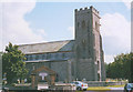
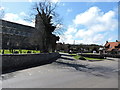
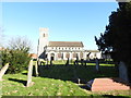
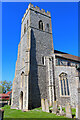
It takes some imagination to view this as anything approaching a sacred site, but it’s worth mentioning for its sheer scale and attractiveness. It does sit beside the church in Upper Sheringham, and taps springs that rise just above it, so once upon a time there may have been deeper significance to the waters than we see now. Immediately north of the church of All Saints is a large water reservoir, walled with flints, at the mouth of which is a brick arch surmounted by a broken pediment: the water pours gently beneath this into a trough and out via two spouts. ‘ANNO PACIS MDCCCXIV’, reads a date-stone, rather optimistically as Napoleon still had a bit of fight left in him at that stage. The Lord of the Manor at the time was apparently responsible.
You may be viewing yesterday's version of this page. To see the most up to date information please register for a free account.
Do not use the above information on other web sites or publications without permission of the contributor.
Nearby Images from Geograph Britain and Ireland:
©2006(licence)
©2015(licence)
©2019(licence)
©2022(licence)
©2014(licence)
The above images may not be of the site on this page, they are loaded from Geograph.
Please Submit an Image of this site or go out and take one for us!
Click here to see more info for this site
Nearby sites
Key: Red: member's photo, Blue: 3rd party photo, Yellow: other image, Green: no photo - please go there and take one, Grey: site destroyed
Download sites to:
KML (Google Earth)
GPX (GPS waypoints)
CSV (Garmin/Navman)
CSV (Excel)
To unlock full downloads you need to sign up as a Contributory Member. Otherwise downloads are limited to 50 sites.
Turn off the page maps and other distractions
Nearby sites listing. In the following links * = Image available
1.3km SW 234° Howe’s Hill Oval Barrow* Round Barrow(s) (TG1340941007)
2.6km E 90° Calves Well* Holy Well or Sacred Spring (TG170419)
4.7km SE 128° Aylmerton Shrieking Pits* Misc. Earthwork (TG1823939072)
4.7km SE 132° Aylmerton Cross* Ancient Cross (TG18073879)
6.4km W 278° Salthouse Heath* Barrow Cemetery (TG07974241)
8.1km W 279° The Hangs* Round Barrow(s) (TG06304270)
10.0km SE 132° Roughton Cursus Cursus (TG222355)
12.6km W 281° Blakeney Downs Barrows Round Barrow(s) (TG01864365)
17.5km S 171° Maiden's Head* Holy Well or Sacred Spring (TG178246)
17.8km ESE 120° Knapton* Modern Stone Circle etc (TG3020433448)
18.2km W 270° Fiddler's Hill (Norfolk)* Round Barrow(s) (TF96134105)
19.7km SSW 200° Pettywell* Holy Well or Sacred Spring (TG086230)
20.0km W 270° Warham Camp* Hillfort (TF94374089)
21.3km W 259° Little Walsingham Holy Well* Holy Well or Sacred Spring (TF93603678)
21.3km W 259° Our Lady of Walsingham Holy Well* Holy Well or Sacred Spring (TF9355136894)
23.6km S 187° Alderford Common Barrow Round Barrow(s) (TG12751828)
24.0km S 190° The Warren Barrow Round Barrow(s) (TG11371798)
24.3km S 173° Horsford Woods Barrow Cemetary* Barrow Cemetery (TG18571780)
25.4km SW 220° North Elmham Chapel* Ancient Temple (TF9888121640)
25.6km ESE 116° Happisburgh Ancient Village or Settlement (TG379315)
26.2km SE 132° Devil's Ditch Ancient Trackway (TG347252)
26.9km W 278° Holkham Camp* Hillfort (TF875443)
29.0km SW 233° Whissonsett wheel-head cross* Ancient Cross (TF91922334)
29.1km W 274° Leath House Roman Barrow* Barrow Cemetery (TF852427)
30.2km W 260° South Creake* Hillfort (TF848352)
View more nearby sites and additional images


 We would like to know more about this location. Please feel free to add a brief description and any relevant information in your own language.
 Wir möchten mehr über diese Stätte erfahren. Bitte zögern Sie nicht, eine kurze Beschreibung und relevante Informationen in Deutsch hinzuzufügen.
 Nous aimerions en savoir encore un peu sur les lieux. S'il vous plaît n'hesitez pas à ajouter une courte description et tous les renseignements pertinents dans votre propre langue.
 Quisieramos informarnos un poco más de las lugares. No dude en añadir una breve descripción y otros datos relevantes en su propio idioma.