


<< Our Photo Pages >> Capel-le-Ferne Bowl Barrow - Round Barrow(s) in England in Kent
Submitted by coldrum on Wednesday, 23 July 2008 Page Views: 4857
Neolithic and Bronze AgeSite Name: Capel-le-Ferne Bowl BarrowCountry: England
NOTE: This site is 1.854 km away from the location you searched for.
County: Kent Type: Round Barrow(s)
Nearest Town: Folkstone
Map Ref: TR26113860
Latitude: 51.102089N Longitude: 1.228315E
Condition:
| 5 | Perfect |
| 4 | Almost Perfect |
| 3 | Reasonable but with some damage |
| 2 | Ruined but still recognisable as an ancient site |
| 1 | Pretty much destroyed, possibly visible as crop marks |
| 0 | No data. |
| -1 | Completely destroyed |
| 5 | Superb |
| 4 | Good |
| 3 | Ordinary |
| 2 | Not Good |
| 1 | Awful |
| 0 | No data. |
| 5 | Can be driven to, probably with disabled access |
| 4 | Short walk on a footpath |
| 3 | Requiring a bit more of a walk |
| 2 | A long walk |
| 1 | In the middle of nowhere, a nightmare to find |
| 0 | No data. |
| 5 | co-ordinates taken by GPS or official recorded co-ordinates |
| 4 | co-ordinates scaled from a detailed map |
| 3 | co-ordinates scaled from a bad map |
| 2 | co-ordinates of the nearest village |
| 1 | co-ordinates of the nearest town |
| 0 | no data |
Be the first person to rate this site - see the 'Contribute!' box in the right hand menu.
Internal Links:
External Links:
I have visited· I would like to visit
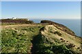
Brian_Eyes visited on 5th Nov 2016 - their rating: Cond: 3 Amb: 4 Access: 4 Access from cliff edge footpath. Big crater in the top of the barrow and a ditch running right through barrow from one side to the other. Hidden from Old and New Dover Roads by thick brambles. Beautiful location on cliff edge overlooking the English Channel.
")
From Exploring Kent's Past: "On the S side of the Dover road at Capel-le-Ferne, on the edge of the cliffs , there is a large bowl barrow measuring some 22.0m in diameter and 2.3m in height. It has been mutilated on the N side by a pond and a large excavation trench has been cut through the centre from NE-SW. There is no trace of a ditch. In 1952 a secondary cremation in an inverted MBA biconical urn with lugs (Abercromby Type 3, Group 2) was found near the top of the mound. The urn is in Deal Castle Museum. A cremation deposit at the east end of the southern part of the barrow was exposed by weathering in 1967." Exploring Kent's Past.
You may be viewing yesterday's version of this page. To see the most up to date information please register for a free account.
")
Do not use the above information on other web sites or publications without permission of the contributor.
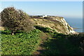
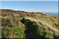
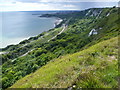
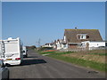
Nearby Images from Geograph Britain and Ireland:
©2020(licence)
©2020(licence)
©2011(licence)
©2010(licence)
©2020(licence)
The above images may not be of the site on this page, they are loaded from Geograph.
Please Submit an Image of this site or go out and take one for us!
Click here to see more info for this site
Nearby sites
Key: Red: member's photo, Blue: 3rd party photo, Yellow: other image, Green: no photo - please go there and take one, Grey: site destroyed
Download sites to:
KML (Google Earth)
GPX (GPS waypoints)
CSV (Garmin/Navman)
CSV (Excel)
To unlock full downloads you need to sign up as a Contributory Member. Otherwise downloads are limited to 50 sites.
Turn off the page maps and other distractions
Nearby sites listing. In the following links * = Image available
3.4km N 6° Moseling's Hole Denehole Ancient Mine, Quarry or other Industry (TR26324199)
3.9km W 267° Sugerloaf Hill Holy Well Holy Well or Sacred Spring (TR222382)
4.1km SW 232° Folkestone moot stones* Marker Stone (TR22963589)
4.4km W 264° Castle Hill Barrows Round Barrow(s) (TR21723798)
4.6km NE 50° Whinless Down Barrows Round Barrow(s) (TR29514167)
4.7km W 264° Caesar's Camp (Folkstone)* Hillfort (TR214379)
5.2km N 10° Minnis Barrows Round Barrow(s) (TR26834375)
5.3km W 266° Cherry Garden Hill Barrow* Round Barrow(s) (TR20833801)
6.1km NW 311° Little Foxholt Barrows Round Barrow(s) (TR21284239)
6.1km NNW 334° St John's Well (Swingfield) Holy Well or Sacred Spring (TR23224401)
6.3km ENE 67° Dover Museum* Museum (TR318413)
6.3km NNE 14° Little Watersend Barrow Round Barrow(s) (TR27394477)
6.4km ENE 63° Lady Well (Dover) Holy Well or Sacred Spring (TR317417)
6.4km NNE 30° Lousyberry Wood Tumuli* Barrow Cemetery (TR29114432)
7.2km ENE 65° Harold's Well Holy Well or Sacred Spring (TR325419)
7.3km ENE 66° Dover Castle* Hillfort (TR3262941822)
7.5km N 10° Stonehall Deneholes Ancient Mine, Quarry or other Industry (TR27104603)
7.8km W 272° Elm Gardens Mound Artificial Mound (TR183385)
9.9km NNE 26° White Caps Barrow Round Barrow(s) (TR30034766)
10.1km W 273° Tolsford Hill Barrows Round Barrow(s) (TR160386)
10.1km WNW 291° Lyminge Barrow Round Barrow(s) (TR16504181)
10.2km WNW 286° Lyminge Anglo Saxon Feasting Hall* Ancient Palace (TR1620440970)
10.2km WNW 285° St. Eadburg's Well Holy Well or Sacred Spring (TR16174088)
10.2km WNW 285° St. Ethelburga's Well (Lyminge)* Holy Well or Sacred Spring (TR161408)
10.6km WSW 252° Holywelle Holy Well or Sacred Spring (TR161349)
View more nearby sites and additional images


 We would like to know more about this location. Please feel free to add a brief description and any relevant information in your own language.
 Wir möchten mehr über diese Stätte erfahren. Bitte zögern Sie nicht, eine kurze Beschreibung und relevante Informationen in Deutsch hinzuzufügen.
 Nous aimerions en savoir encore un peu sur les lieux. S'il vous plaît n'hesitez pas à ajouter une courte description et tous les renseignements pertinents dans votre propre langue.
 Quisieramos informarnos un poco más de las lugares. No dude en añadir una breve descripción y otros datos relevantes en su propio idioma.