

<< Text Pages >> Dolmen du Pech Nadal - Burial Chamber or Dolmen in France in Midi:Lot (46)
Submitted by holger_rix on Monday, 14 March 2016 Page Views: 848
Neolithic and Bronze AgeSite Name: Dolmen du Pech NadalCountry: France
NOTE: This site is 5.055 km away from the location you searched for.
Département: Midi:Lot (46) Type: Burial Chamber or Dolmen
Nearest Town: Cahors Nearest Village: Montcuq
Latitude: 44.316241N Longitude: 1.251697E
Condition:
| 5 | Perfect |
| 4 | Almost Perfect |
| 3 | Reasonable but with some damage |
| 2 | Ruined but still recognisable as an ancient site |
| 1 | Pretty much destroyed, possibly visible as crop marks |
| 0 | No data. |
| -1 | Completely destroyed |
| 5 | Superb |
| 4 | Good |
| 3 | Ordinary |
| 2 | Not Good |
| 1 | Awful |
| 0 | No data. |
| 5 | Can be driven to, probably with disabled access |
| 4 | Short walk on a footpath |
| 3 | Requiring a bit more of a walk |
| 2 | A long walk |
| 1 | In the middle of nowhere, a nightmare to find |
| 0 | No data. |
| 5 | co-ordinates taken by GPS or official recorded co-ordinates |
| 4 | co-ordinates scaled from a detailed map |
| 3 | co-ordinates scaled from a bad map |
| 2 | co-ordinates of the nearest village |
| 1 | co-ordinates of the nearest town |
| 0 | no data |
Be the first person to rate this site - see the 'Contribute!' box in the right hand menu.
Internal Links:
External Links:
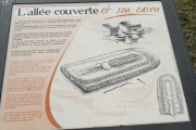
Burial Chamber (Dolmen) in Midi:Lot (46)
Montcuq, Montcuq-en-Quercy-Blanc, Cahors, Lot, Languedoc-Roussillon-Midi-Pyrénées
Source: T4T35.fr
You may be viewing yesterday's version of this page. To see the most up to date information please register for a free account.
Do not use the above information on other web sites or publications without permission of the contributor.
Nearby Images from Flickr
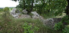

The above images may not be of the site on this page, but were taken nearby. They are loaded from Flickr so please click on them for image credits.
Click here to see more info for this site
Nearby sites
Click here to view sites on an interactive map of the areaKey: Red: member's photo, Blue: 3rd party photo, Yellow: other image, Green: no photo - please go there and take one, Grey: site destroyed
Download sites to:
KML (Google Earth)
GPX (GPS waypoints)
CSV (Garmin/Navman)
CSV (Excel)
To unlock full downloads you need to sign up as a Contributory Member. Otherwise downloads are limited to 50 sites.
Turn off the page maps and other distractions
Nearby sites listing. In the following links * = Image available
7.3km NW 321° Grotte de Roland Cave or Rock Shelter
7.5km NW 319° Dolmen de Roland Burial Chamber or Dolmen
8.3km S 182° Dolmen de la Borie (Tréjouls) Burial Chamber or Dolmen
9.6km ESE 122° Menhirs de Lasplanes Stone Row / Alignment
11.1km NE 52° Peyre Levade (Labastide Marnhac)* Burial Chamber or Dolmen
13.2km WSW 245° Dolmen dit Peyresourde Burial Chamber or Dolmen
15.0km N 9° Menhir de la Pierre Levée (Saint-Vincent)* Standing Stone (Menhir)
15.4km N 8° Menhir La Pierre Longue (Foussal)* Modern Stone Circle etc
18.0km NW 320° Garroustes Dolmen* Burial Chamber or Dolmen
19.1km WNW 294° Allée de Saltres* Passage Grave
19.2km N 8° Luzech Oppidum Ancient Village or Settlement
20.1km NE 45° Fontaine des Chartreux* Holy Well or Sacred Spring
20.1km NW 316° Dolmen de Bartassou Burial Chamber or Dolmen
20.2km WNW 296° Toumbos dels Djayans* Barrow Cemetery
20.7km S 182° Autel Druidique de Saint-Jean* Holed Stone
22.2km N 354° Dolmen dit los Tres Peyres* Burial Chamber or Dolmen
22.2km N 353° Dolmen des Las Tres Peyres* Burial Chamber or Dolmen
22.3km N 352° Fauteuil de César* Rock Cut Tomb
22.6km ESE 106° Dolmen de la Butte de Saint-Simon* Burial Chamber or Dolmen
23.0km N 354° Le chaos de Roquebert* Rock Outcrop
23.5km E 80° Peyre Levade (La Borie Rouge)* Burial Chamber or Dolmen
23.7km N 354° La Bertrandoune Dolmen* Burial Chamber or Dolmen
24.2km N 354° Les Trois Pierres (Les Junies)* Burial Chamber or Dolmen
24.8km N 357° Dolmen de la Baune Burial Chamber or Dolmen
25.3km SSE 167° Piquecos tumulus Chambered Tomb
View more nearby sites and additional images


 We would like to know more about this location. Please feel free to add a brief description and any relevant information in your own language.
 Wir möchten mehr über diese Stätte erfahren. Bitte zögern Sie nicht, eine kurze Beschreibung und relevante Informationen in Deutsch hinzuzufügen.
 Nous aimerions en savoir encore un peu sur les lieux. S'il vous plaît n'hesitez pas à ajouter une courte description et tous les renseignements pertinents dans votre propre langue.
 Quisieramos informarnos un poco más de las lugares. No dude en añadir una breve descripción y otros datos relevantes en su propio idioma.