


<< Other Photo Pages >> Howe’s Hill Oval Barrow - Round Barrow(s) in England in Norfolk
Submitted by Andy B on Wednesday, 06 September 2023 Page Views: 5890
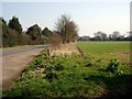
Neolithic and Bronze AgeSite Name: Howe’s Hill Oval BarrowCountry: England County: Norfolk Type: Round Barrow(s)
Nearest Town: Sheringham
Map Ref: TG1340941007
Latitude: 52.924047N Longitude: 1.173305E
Condition:
| 5 | Perfect |
| 4 | Almost Perfect |
| 3 | Reasonable but with some damage |
| 2 | Ruined but still recognisable as an ancient site |
| 1 | Pretty much destroyed, possibly visible as crop marks |
| 0 | No data. |
| -1 | Completely destroyed |
| 5 | Superb |
| 4 | Good |
| 3 | Ordinary |
| 2 | Not Good |
| 1 | Awful |
| 0 | No data. |
| 5 | Can be driven to, probably with disabled access |
| 4 | Short walk on a footpath |
| 3 | Requiring a bit more of a walk |
| 2 | A long walk |
| 1 | In the middle of nowhere, a nightmare to find |
| 0 | No data. |
| 5 | co-ordinates taken by GPS or official recorded co-ordinates |
| 4 | co-ordinates scaled from a detailed map |
| 3 | co-ordinates scaled from a bad map |
| 2 | co-ordinates of the nearest village |
| 1 | co-ordinates of the nearest town |
| 0 | no data |
Internal Links:
External Links:
")
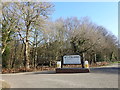
The National Trust, who now look after the site as part of Sheringham Park, think a previous landowner may have planted a decorative scheme of Holm oak around the mound.
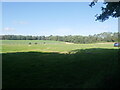
The oval barrow earthwork has a height of 1.5m and measures c.32m along an ENE-WSW axis by c.23m NNW-SSE. The bowl barrow stands on this mound near its eastern end, and is defined by a distinct break in the profile of the earthwork. The later barrow covers a circular area c.14m in diameter and is c.1m high, giving the earthwork an overall maximum height of c.2m. Surrounding the oval mound, at a distance of up to 2m are two ditches. Situated 500m WSW of Wood Farm
Oxford Archaeology have made a 3D scan of the barrows. View the model at Sketchfab .
Note: Sheringham Park Tumuli Walk, Mon/Tues 11/12th September, more details in the comments
You may be viewing yesterday's version of this page. To see the most up to date information please register for a free account.
")
Do not use the above information on other web sites or publications without permission of the contributor.
Nearby Images from Geograph Britain and Ireland:
©2023(licence)
©2019(licence)
©2013(licence)
©2023(licence)
©2007(licence)
The above images may not be of the site on this page, they are loaded from Geograph.
Please Submit an Image of this site or go out and take one for us!
Click here to see more info for this site
Nearby sites
Key: Red: member's photo, Blue: 3rd party photo, Yellow: other image, Green: no photo - please go there and take one, Grey: site destroyed
Download sites to:
KML (Google Earth)
GPX (GPS waypoints)
CSV (Garmin/Navman)
CSV (Excel)
To unlock full downloads you need to sign up as a Contributory Member. Otherwise downloads are limited to 50 sites.
Turn off the page maps and other distractions
Nearby sites listing. In the following links * = Image available
1.3km NE 54° Church Conduit* Holy Well or Sacred Spring (TG144418)
3.7km ENE 79° Calves Well* Holy Well or Sacred Spring (TG170419)
5.1km ESE 118° Aylmerton Cross* Ancient Cross (TG18073879)
5.2km ESE 114° Aylmerton Shrieking Pits* Misc. Earthwork (TG1823939072)
5.6km WNW 287° Salthouse Heath* Barrow Cemetery (TG07974241)
7.3km WNW 286° The Hangs* Round Barrow(s) (TG06304270)
10.3km SE 125° Roughton Cursus Cursus (TG222355)
11.8km WNW 285° Blakeney Downs Barrows Round Barrow(s) (TG01864365)
17.0km SSE 168° Maiden's Head* Holy Well or Sacred Spring (TG178246)
17.2km W 273° Fiddler's Hill (Norfolk)* Round Barrow(s) (TF96134105)
18.4km ESE 117° Knapton* Modern Stone Circle etc (TG3020433448)
18.6km SSW 197° Pettywell* Holy Well or Sacred Spring (TG086230)
19.0km W 272° Warham Camp* Hillfort (TF94374089)
20.2km W 260° Little Walsingham Holy Well* Holy Well or Sacred Spring (TF93603678)
20.2km W 261° Our Lady of Walsingham Holy Well* Holy Well or Sacred Spring (TF9355136894)
22.7km S 184° Alderford Common Barrow Round Barrow(s) (TG12751828)
23.1km S 188° The Warren Barrow Round Barrow(s) (TG11371798)
23.7km S 170° Horsford Woods Barrow Cemetary* Barrow Cemetery (TG18571780)
24.2km SW 219° North Elmham Chapel* Ancient Temple (TF9888121640)
26.0km W 280° Holkham Camp* Hillfort (TF875443)
26.2km ESE 114° Happisburgh Ancient Village or Settlement (TG379315)
26.5km SE 129° Devil's Ditch Ancient Trackway (TG347252)
27.8km SW 233° Whissonsett wheel-head cross* Ancient Cross (TF91922334)
28.2km W 276° Leath House Roman Barrow* Barrow Cemetery (TF852427)
29.1km W 261° South Creake* Hillfort (TF848352)
View more nearby sites and additional images


 We would like to know more about this location. Please feel free to add a brief description and any relevant information in your own language.
 Wir möchten mehr über diese Stätte erfahren. Bitte zögern Sie nicht, eine kurze Beschreibung und relevante Informationen in Deutsch hinzuzufügen.
 Nous aimerions en savoir encore un peu sur les lieux. S'il vous plaît n'hesitez pas à ajouter une courte description et tous les renseignements pertinents dans votre propre langue.
 Quisieramos informarnos un poco más de las lugares. No dude en añadir una breve descripción y otros datos relevantes en su propio idioma.