


<< Text Pages >> Parc Archéologique de Beynac - Museum in France in Aquitaine:Dordogne (24)
Submitted by TheCaptain on Saturday, 16 April 2005 Page Views: 2517
MuseumsSite Name: Parc Archéologique de BeynacCountry: France
NOTE: This site is 0.267 km away from the location you searched for.
Département: Aquitaine:Dordogne (24) Type: Museum
Nearest Town: Sarlat-la-Canéda Nearest Village: Beynac-et-Cazenac
Latitude: 44.842647N Longitude: 1.144737E
Condition:
| 5 | Perfect |
| 4 | Almost Perfect |
| 3 | Reasonable but with some damage |
| 2 | Ruined but still recognisable as an ancient site |
| 1 | Pretty much destroyed, possibly visible as crop marks |
| 0 | No data. |
| -1 | Completely destroyed |
| 5 | Superb |
| 4 | Good |
| 3 | Ordinary |
| 2 | Not Good |
| 1 | Awful |
| 0 | No data. |
| 5 | Can be driven to, probably with disabled access |
| 4 | Short walk on a footpath |
| 3 | Requiring a bit more of a walk |
| 2 | A long walk |
| 1 | In the middle of nowhere, a nightmare to find |
| 0 | No data. |
| 5 | co-ordinates taken by GPS or official recorded co-ordinates |
| 4 | co-ordinates scaled from a detailed map |
| 3 | co-ordinates scaled from a bad map |
| 2 | co-ordinates of the nearest village |
| 1 | co-ordinates of the nearest town |
| 0 | no data |
Internal Links:
External Links:
Museum in Dordogne
Website: Parc Archéologique de Beynac
You may be viewing yesterday's version of this page. To see the most up to date information please register for a free account.
Do not use the above information on other web sites or publications without permission of the contributor.
Nearby Images from Flickr
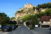
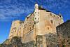
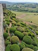
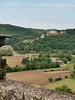
The above images may not be of the site on this page, but were taken nearby. They are loaded from Flickr so please click on them for image credits.
Click here to see more info for this site
Nearby sites
Click here to view sites on an interactive map of the areaKey: Red: member's photo, Blue: 3rd party photo, Yellow: other image, Green: no photo - please go there and take one, Grey: site destroyed
Download sites to:
KML (Google Earth)
GPX (GPS waypoints)
CSV (Garmin/Navman)
CSV (Excel)
To unlock full downloads you need to sign up as a Contributory Member. Otherwise downloads are limited to 50 sites.
Turn off the page maps and other distractions
Nearby sites listing. In the following links * = Image available
1.8km ESE 117° Grotte du Roc de Vezac Cave or Rock Shelter
4.7km SSE 156° Peyre Pincade* Standing Stone (Menhir)
4.8km E 79° Pierre du Diable (Vitrac)* Burial Chamber or Dolmen
4.9km SSE 167° Menhir de Lacoste n°2* Standing Stone (Menhir)
5.2km S 173° Menhir de Lacoste n°1* Standing Stone (Menhir)
5.6km NNE 12° La Croix Petite menhir* Standing Stone (Menhir)
6.8km SE 137° Falaise du Conte Ancient Village or Settlement
7.0km SE 129° Grotte de la Martine Cave or Rock Shelter
7.5km NNW 348° Abri du Pas-Estrét Cave or Rock Shelter
7.6km ESE 122° Grotte du Pigeonnier Cave or Rock Shelter
7.7km N 358° Grotte de Puymartin Cave or Rock Shelter
8.1km SE 125° Grotte du Mammouth Cave or Rock Shelter
8.7km ESE 114° Giverzac Dolmen* Burial Chamber or Dolmen
9.8km SSW 194° Dolmen de Pomarède* Burial Chamber or Dolmen
11.0km SW 223° Cayre Levat* Burial Chamber or Dolmen
11.0km NNW 329° Grotte dite Sous le Grand Lac Cave or Rock Shelter
11.3km WNW 292° Polissoirs du Bousquet* Polissoir
11.5km NNW 328° Grotte de Bernifal* Cave or Rock Shelter
11.6km NNW 343° Grotte de Commarque* Cave or Rock Shelter
12.0km NNW 346° Abri de Laussel* Cave or Rock Shelter
12.1km NNW 342° Abri du Cap-Blanc* Cave or Rock Shelter
12.2km NNW 339° Abri de la Grèze Cave or Rock Shelter
12.5km SSW 199° Menhir de Peyre longue* Standing Stone (Menhir)
12.7km NNW 330° Roc de Cazelle* Ancient Village or Settlement
12.7km SW 216° Langlade Dolmen* Burial Chamber or Dolmen
View more nearby sites and additional images


 We would like to know more about this location. Please feel free to add a brief description and any relevant information in your own language.
 Wir möchten mehr über diese Stätte erfahren. Bitte zögern Sie nicht, eine kurze Beschreibung und relevante Informationen in Deutsch hinzuzufügen.
 Nous aimerions en savoir encore un peu sur les lieux. S'il vous plaît n'hesitez pas à ajouter une courte description et tous les renseignements pertinents dans votre propre langue.
 Quisieramos informarnos un poco más de las lugares. No dude en añadir una breve descripción y otros datos relevantes en su propio idioma.