


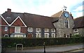
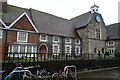
<< Other Photo Pages >> Museum of Canterbury - Museum in England in Kent
Submitted by coldrum on Tuesday, 26 June 2007 Page Views: 4367
MuseumsSite Name: Museum of CanterburyCountry: England County: Kent Type: Museum
Nearest Town: Canterbury
Map Ref: TR1472257767
Latitude: 51.278564N Longitude: 1.077360E
Condition:
| 5 | Perfect |
| 4 | Almost Perfect |
| 3 | Reasonable but with some damage |
| 2 | Ruined but still recognisable as an ancient site |
| 1 | Pretty much destroyed, possibly visible as crop marks |
| 0 | No data. |
| -1 | Completely destroyed |
| 5 | Superb |
| 4 | Good |
| 3 | Ordinary |
| 2 | Not Good |
| 1 | Awful |
| 0 | No data. |
| 5 | Can be driven to, probably with disabled access |
| 4 | Short walk on a footpath |
| 3 | Requiring a bit more of a walk |
| 2 | A long walk |
| 1 | In the middle of nowhere, a nightmare to find |
| 0 | No data. |
| 5 | co-ordinates taken by GPS or official recorded co-ordinates |
| 4 | co-ordinates scaled from a detailed map |
| 3 | co-ordinates scaled from a bad map |
| 2 | co-ordinates of the nearest village |
| 1 | co-ordinates of the nearest town |
| 0 | no data |
Internal Links:
External Links:
Museum in Kent
Prehistoric and Anglo-Saxon displays.
Museum of Canterbury with Rupert Bear Museum
You may be viewing yesterday's version of this page. To see the most up to date information please register for a free account.
Do not use the above information on other web sites or publications without permission of the contributor.
davidmorgan has found this location on Google Street View:
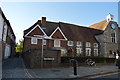
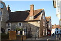
Nearby Images from Geograph Britain and Ireland:

©2007(licence)
©2011(licence)
©2016(licence)
©2016(licence)
©2018(licence)
The above images may not be of the site on this page, they are loaded from Geograph.
Please Submit an Image of this site or go out and take one for us!
Click here to see more info for this site
Nearby sites
Key: Red: member's photo, Blue: 3rd party photo, Yellow: other image, Green: no photo - please go there and take one, Grey: site destroyed
Download sites to:
KML (Google Earth)
GPX (GPS waypoints)
CSV (Garmin/Navman)
CSV (Excel)
To unlock full downloads you need to sign up as a Contributory Member. Otherwise downloads are limited to 50 sites.
Turn off the page maps and other distractions
Nearby sites listing. In the following links * = Image available
296m ENE 78° Sunwin's Well Holy Well or Sacred Spring (TR15015784)
307m ENE 67° St. Thomas Becket's Well Holy Well or Sacred Spring (TR150579)
378m E 87° St Thomas's Well (Canterbury)* Holy Well or Sacred Spring (TR151578)
401m S 174° Dane John Mound* Artificial Mound (TR14785737)
600m NNE 30° St Rhadegund's Bath Holy Well or Sacred Spring (TR150583)
694m E 93° St Augustine's Abbey Standing Stone* Ancient Cross (TR1541857755)
1.8km WNW 283° Black Prince's Well* Holy Well or Sacred Spring (TR129581)
3.1km W 269° Bigbury Camp* Hillfort (TR116576)
3.5km ENE 72° Fordwich Paleolithic Site Not Known (by us) (TR180590)
3.9km SSW 203° Iffin Wood Bowl Barrow Round Barrow(s) (TR13335407)
4.0km ENE 63° Our Lady's Well (Fordwich) Holy Well or Sacred Spring (TR18225970)
4.3km SE 142° Bridge Iron Age Settlement* Ancient Village or Settlement (TR175545)
4.4km S 171° Whitehill Wood Barrow Round Barrow(s) (TR156535)
5.4km ESE 106° Bekesbourne* Holy Well or Sacred Spring (TR20005646)
5.5km E 80° Arrianes Well Holy Well or Sacred Spring (TR201589)
5.7km SE 138° Hanging Hill Barrow Cemetary Barrow Cemetery (TR18725363)
6.2km SSE 160° Gorsley Wood Barrows Round Barrow(s) (TR17095201)
6.3km WSW 248° Pilgrims Way 9 Ancient Trackway (TR090552)
6.3km NNW 344° Clowes Wood Barrows* Round Barrow(s) (TR12746378)
6.4km SE 137° Barham Downs Barrow Round Barrow(s) (TR19295324)
6.5km SSE 165° Gorsley Wood Mound Artificial Mound (TR167516)
6.6km SE 139° Bishopsbourne Barrows Barrow Cemetery (TR19225296)
7.3km SSW 209° Mounts Wood Barrow* Round Barrow(s) (TR11455126)
7.4km SW 227° Denge Wood Earthworks Misc. Earthwork (TR095525)
7.6km S 170° Bursted Wood Barrow Round Barrow(s) (TR16345036)
View more nearby sites and additional images


 We would like to know more about this location. Please feel free to add a brief description and any relevant information in your own language.
 Wir möchten mehr über diese Stätte erfahren. Bitte zögern Sie nicht, eine kurze Beschreibung und relevante Informationen in Deutsch hinzuzufügen.
 Nous aimerions en savoir encore un peu sur les lieux. S'il vous plaît n'hesitez pas à ajouter une courte description et tous les renseignements pertinents dans votre propre langue.
 Quisieramos informarnos un poco más de las lugares. No dude en añadir una breve descripción y otros datos relevantes en su propio idioma.