


<< Text Pages >> Lawford - Cursus in England in Essex
Submitted by EssexMan on Wednesday, 07 April 2010 Page Views: 3746
Neolithic and Bronze AgeSite Name: LawfordCountry: England
NOTE: This site is 2.507 km away from the location you searched for.
County: Essex Type: Cursus
Nearest Town: Manningtree Nearest Village: Lawford
Map Ref: TM097303 Landranger Map Number: 168
Latitude: 51.931689N Longitude: 1.048807E
Condition:
| 5 | Perfect |
| 4 | Almost Perfect |
| 3 | Reasonable but with some damage |
| 2 | Ruined but still recognisable as an ancient site |
| 1 | Pretty much destroyed, possibly visible as crop marks |
| 0 | No data. |
| -1 | Completely destroyed |
| 5 | Superb |
| 4 | Good |
| 3 | Ordinary |
| 2 | Not Good |
| 1 | Awful |
| 0 | No data. |
| 5 | Can be driven to, probably with disabled access |
| 4 | Short walk on a footpath |
| 3 | Requiring a bit more of a walk |
| 2 | A long walk |
| 1 | In the middle of nowhere, a nightmare to find |
| 0 | No data. |
| 5 | co-ordinates taken by GPS or official recorded co-ordinates |
| 4 | co-ordinates scaled from a detailed map |
| 3 | co-ordinates scaled from a bad map |
| 2 | co-ordinates of the nearest village |
| 1 | co-ordinates of the nearest town |
| 0 | no data |
Internal Links:
External Links:
Discredited Cursus in Essex
Status: Discredited
Extent: 350mx15m
Roman road leading to Colchester
Note: This location marks one terminal (end) of a cursus monument. The location of the other terminal can be found in the Nearby Site list below.
You may be viewing yesterday's version of this page. To see the most up to date information please register for a free account.
Do not use the above information on other web sites or publications without permission of the contributor.
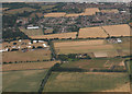
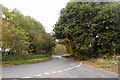
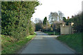
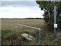
Nearby Images from Geograph Britain and Ireland:
©2010(licence)
©2016(licence)
©2019(licence)
©2017(licence)
©2017(licence)
The above images may not be of the site on this page, they are loaded from Geograph.
Please Submit an Image of this site or go out and take one for us!
Click here to see more info for this site
Nearby sites
Key: Red: member's photo, Blue: 3rd party photo, Yellow: other image, Green: no photo - please go there and take one, Grey: site destroyed
Download sites to:
KML (Google Earth)
GPX (GPS waypoints)
CSV (Garmin/Navman)
CSV (Excel)
To unlock full downloads you need to sign up as a Contributory Member. Otherwise downloads are limited to 50 sites.
Turn off the page maps and other distractions
Nearby sites listing. In the following links * = Image available
199m W 272° Lawford C Cursus Cursus (TM095303)
223m WSW 246° Lawford 2 Long Barrow (TM095302)
446m WSW 246° Lawford Cursus (TM093301)
1.0km WNW 302° Lawford Timber Circle (TM088308)
2.3km WNW 290° Lawford B Cursus Cursus (TM075310)
2.4km WNW 292° Lawford 1 Long Barrow (TM074311)
3.1km SSW 197° Little Bromley Henge (TM089273)
4.0km NW 307° Dedham Cursus (TM064326)
5.9km NW 314° Stratford St. Mary B Cursus Cursus (TM05253425)
6.2km NW 312° Stratford St. Mary A Cursus Cursus (TM049343)
6.6km NW 312° Stratford St. Mary A Cursus Cursus (TM046345)
7.0km SSE 154° Little Bentley Henge (TM130241)
7.9km S 177° Great Bentley Henge (TM104224)
8.3km NW 310° Stoke by Nayland Cursus (TM031353)
9.1km WNW 288° Boxted Henge (TM009327)
9.4km WSW 236° Greenstead Stones* Natural Stone / Erratic / Other Natural Feature (TM021248)
9.7km SW 233° Annan Road Bronze Age Barrow Cemetery* Barrow Cemetery (TM0215024164)
10.6km SSW 201° Alresford Hill Cairn (TM06282022)
11.1km WSW 246° Colchester Castle Museum* Museum (TL998253)
11.5km WSW 243° St John's Green (Colchester) Cairn (TL99642468)
11.9km WNW 295° Stoke by Nayland A Cursus Cursus (TL987348)
12.0km WSW 249° Sheepden Dyke Ancient Village or Settlement (TL987255)
12.1km SW 231° Tamworth Mound Misc. Earthwork (TM0065922209)
12.3km WSW 257° Lexden Dyke* Ancient Village or Settlement (TL978270)
12.7km S 173° Flag Inn (St Osyth) Cairn (TM11771777)
View more nearby sites and additional images


 We would like to know more about this location. Please feel free to add a brief description and any relevant information in your own language.
 Wir möchten mehr über diese Stätte erfahren. Bitte zögern Sie nicht, eine kurze Beschreibung und relevante Informationen in Deutsch hinzuzufügen.
 Nous aimerions en savoir encore un peu sur les lieux. S'il vous plaît n'hesitez pas à ajouter une courte description et tous les renseignements pertinents dans votre propre langue.
 Quisieramos informarnos un poco más de las lugares. No dude en añadir una breve descripción y otros datos relevantes en su propio idioma.