

<< Our Photo Pages >> Julliberrie's Grave - Long Barrow in England in Kent
Submitted by bec-zog on Friday, 27 February 2004 Page Views: 14836
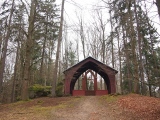
Neolithic and Bronze AgeSite Name: Julliberrie's GraveCountry: England
NOTE: This site is 1.104 km away from the location you searched for.
County: Kent Type: Long Barrow
Nearest Town: Canterbury Nearest Village: Chilham
Map Ref: TR077532 Landranger Map Number: 179
Latitude: 51.240155N Longitude: 0.974175E
Condition:
| 5 | Perfect |
| 4 | Almost Perfect |
| 3 | Reasonable but with some damage |
| 2 | Ruined but still recognisable as an ancient site |
| 1 | Pretty much destroyed, possibly visible as crop marks |
| 0 | No data. |
| -1 | Completely destroyed |
| 5 | Superb |
| 4 | Good |
| 3 | Ordinary |
| 2 | Not Good |
| 1 | Awful |
| 0 | No data. |
| 5 | Can be driven to, probably with disabled access |
| 4 | Short walk on a footpath |
| 3 | Requiring a bit more of a walk |
| 2 | A long walk |
| 1 | In the middle of nowhere, a nightmare to find |
| 0 | No data. |
| 5 | co-ordinates taken by GPS or official recorded co-ordinates |
| 4 | co-ordinates scaled from a detailed map |
| 3 | co-ordinates scaled from a bad map |
| 2 | co-ordinates of the nearest village |
| 1 | co-ordinates of the nearest town |
| 0 | no data |
Internal Links:
External Links:
I have visited· I would like to visit
Majick123 would like to visit
Brian_Eyes visited on 27th Nov 2016 - their rating: Cond: 3 Amb: 4 Access: 4 Location is very nice - the north end of the barrow looks down from a ridge onto the river below. difficult to find without an OS map - climb footpath from the river and turn right at junction after climbing for about 200 meters. Or take an OS map :)
Twistytwirly visited on 7th May 2016 - their rating: Cond: 3 Amb: 4 Access: 4
Average ratings for this site from all visit loggers: Condition: 3 Ambience: 4 Access: 4
")
A flint axe head dating to circa 2000BC was found in the core. A ditch extends along eastern and western side side and southern end. In the upper layer of the ditch 4 Romano British burials were found.
bec-zog wrote: It is the only long barrow in Kent without a stone burial chamber. [I don't think this is correct - see also Shrub's Wood and Jacket's Field long barrows (nearby sites list) - MegP Ed]
A chalk pit has damaged the northern end.
Reference: R Jessup Ant J. 19(1939)260
You may be viewing yesterday's version of this page. To see the most up to date information please register for a free account.
")
")
")
")
")
")
")
")
")
Do not use the above information on other web sites or publications without permission of the contributor.
Click here to see more info for this site
Nearby sites
Key: Red: member's photo, Blue: 3rd party photo, Yellow: other image, Green: no photo - please go there and take one, Grey: site destroyed
Download sites to:
KML (Google Earth)
GPX (GPS waypoints)
CSV (Garmin/Navman)
CSV (Excel)
To unlock full downloads you need to sign up as a Contributory Member. Otherwise downloads are limited to 50 sites.
Turn off the page maps and other distractions
Nearby sites listing. In the following links * = Image available
1.9km ESE 114° Denge Wood Earthworks Misc. Earthwork (TR095525)
2.0km SE 127° Denge Wood Tumulus Round Barrow(s) (TR0933852069)
2.4km NE 35° Pilgrims Way 9 Ancient Trackway (TR090552)
3.2km SE 144° Eggringe Wood Barrow Cemetery* Barrow Cemetery (TR097507)
3.4km SE 137° Eggringe Wood East Bowl Barrow* Round Barrow(s) (TR10115083)
3.4km SSE 147° Eggringe Wood Western Bowl Barrow* Round Barrow(s) (TR09655041)
3.4km SE 137° Eggringe Wood Round Barrow* Round Barrow(s) (TR10155079)
3.5km SSE 148° Pennypot Lane Bowl Barrow* Round Barrow(s) (TR09675035)
3.9km SSE 152° Eggringe Wood Bowl Barrow Round Barrow(s) (TR09664979)
4.0km SE 136° Mounts Wood Barrow Round Barrow(s) (TR10615043)
4.2km ESE 120° Mounts Wood Barrow* Round Barrow(s) (TR11455126)
4.2km SSE 148° Buckholt Farm Barrows Round Barrow(s) (TR10114972)
4.5km WSW 237° Kings Wood Barrow* Round Barrow(s) (TR04005060)
4.7km S 185° Warren Wood Saucer Barrow Round Barrow(s) (TR07444852)
5.2km WSW 237° Kings Wood Mound* Misc. Earthwork (TR034502)
5.7km SW 233° Jackets Field Long Barrow* Long Barrow (TR03304961)
5.7km E 84° Iffin Wood Bowl Barrow Round Barrow(s) (TR13335407)
5.9km NE 44° Bigbury Camp* Hillfort (TR116576)
6.2km S 190° The Junipers Tumulus* Round Barrow(s) (TR069470)
7.1km NE 49° Black Prince's Well* Holy Well or Sacred Spring (TR129581)
7.3km SSW 208° Pilgrims Way 8 Ancient Trackway (TR045466)
7.5km SSW 194° St. Eustace's Well* Holy Well or Sacred Spring (TR0617045889)
7.6km SSE 166° Shrub's Wood Long Barrow* Long Barrow (TR09914587)
7.9km E 90° Whitehill Wood Barrow Round Barrow(s) (TR156535)
8.0km WSW 250° The Lees Denehole Ancient Mine, Quarry or other Industry (TR003502)
View more nearby sites and additional images


 We would like to know more about this location. Please feel free to add a brief description and any relevant information in your own language.
 Wir möchten mehr über diese Stätte erfahren. Bitte zögern Sie nicht, eine kurze Beschreibung und relevante Informationen in Deutsch hinzuzufügen.
 Nous aimerions en savoir encore un peu sur les lieux. S'il vous plaît n'hesitez pas à ajouter une courte description et tous les renseignements pertinents dans votre propre langue.
 Quisieramos informarnos un poco más de las lugares. No dude en añadir una breve descripción y otros datos relevantes en su propio idioma.