


<< Text Pages >> Artificial Mound near Wrenshall Farm - Artificial Mound in England in Suffolk
Submitted by Anonymous on Saturday, 04 April 2015 Page Views: 2264
Multi-periodSite Name: Artificial Mound near Wrenshall FarmCountry: England
NOTE: This site is 2.644 km away from the location you searched for.
County: Suffolk Type: Artificial Mound
Nearest Town: Walsham Le Willows
Map Ref: TL9836071843
Latitude: 52.308858N Longitude: 0.908289E
Condition:
| 5 | Perfect |
| 4 | Almost Perfect |
| 3 | Reasonable but with some damage |
| 2 | Ruined but still recognisable as an ancient site |
| 1 | Pretty much destroyed, possibly visible as crop marks |
| 0 | No data. |
| -1 | Completely destroyed |
| 5 | Superb |
| 4 | Good |
| 3 | Ordinary |
| 2 | Not Good |
| 1 | Awful |
| 0 | No data. |
| 5 | Can be driven to, probably with disabled access |
| 4 | Short walk on a footpath |
| 3 | Requiring a bit more of a walk |
| 2 | A long walk |
| 1 | In the middle of nowhere, a nightmare to find |
| 0 | No data. |
| 5 | co-ordinates taken by GPS or official recorded co-ordinates |
| 4 | co-ordinates scaled from a detailed map |
| 3 | co-ordinates scaled from a bad map |
| 2 | co-ordinates of the nearest village |
| 1 | co-ordinates of the nearest town |
| 0 | no data |
Be the first person to rate this site - see the 'Contribute!' box in the right hand menu.
Internal Links:
External Links:
Artificial Mound in Suffolk
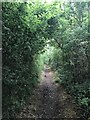
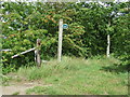
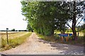
I was staying in a cabin for a few days and took a public footpath from Upthorpe to Walsham Le Willows (Suffolk). Passed this tree-covered mound in an otherwise flat landscape. Appears to be aligned North-South.
Google Earth
https://www.google.co.uk/maps/@52.3087227,0.9077148,245m/data=!3m1!1e3
Street View
https://www.google.co.uk/maps/@52.308939,0.911291,3a,21.4y,265.92h,87.54t/data=!3m4!1e1!3m2!1sJ9SdzDJRCop5iKwOu9DXHQ!2e0
OS via Bing, triangle between Potash Farm and Wrenshall Farm
http://binged.it/1G9GfNl
You may be viewing yesterday's version of this page. To see the most up to date information please register for a free account.
Do not use the above information on other web sites or publications without permission of the contributor.
Nearby Images from Geograph Britain and Ireland:
©2021(licence)
©2009(licence)
©2011(licence)
©2019(licence)
©2006(licence)
The above images may not be of the site on this page, they are loaded from Geograph.
Please Submit an Image of this site or go out and take one for us!
Click here to see more info for this site
Nearby sites
Key: Red: member's photo, Blue: 3rd party photo, Yellow: other image, Green: no photo - please go there and take one, Grey: site destroyed
Download sites to:
KML (Google Earth)
GPX (GPS waypoints)
CSV (Garmin/Navman)
CSV (Excel)
To unlock full downloads you need to sign up as a Contributory Member. Otherwise downloads are limited to 50 sites.
Turn off the page maps and other distractions
Nearby sites listing. In the following links * = Image available
5.3km WSW 237° Pakenham Cursus Cursus (TL940688)
7.2km NNE 33° St. Mary's Well (Thelnetham)* Holy Well or Sacred Spring (TM0201578071)
8.9km NNW 343° Knettishall bowl barrow* Round Barrow(s) (TL9546280239)
9.0km WNW 287° Troston Mount* Round Barrow(s) (TL896741)
9.0km WNW 293° Honington Barrows Round Barrow(s) (TL899751)
9.2km S 187° Lady Well, Woolpit* Holy Well or Sacred Spring (TL9763362676)
9.4km S 188° Woolpit Cross* Ancient Cross (TL974625)
9.9km N 5° Devil's Ditch* Misc. Earthwork (TL9879281705)
9.9km N 7° Home Covert Tumulus* Round Barrow(s) (TL99138177)
10.0km N 4° Riddlesworth Tumulus Round Barrow(s) (TL98648180)
10.0km WNW 286° Black Hill-Suffolk* Round Barrow(s) (TL886742)
10.6km WSW 245° St. John's Well (Suffolk)* Holy Well or Sacred Spring (TL889669)
11.4km NE 39° South Lopham Ox-Foot Stone* Natural Stone / Erratic / Other Natural Feature (TM05178098)
11.6km N 351° West Harling Heath Barrows Round Barrow(s) (TL96068320)
11.6km N 5° Soldier's Hill Round Barrow(s) (TL99008346)
12.2km W 281° Seven hills, Rymer Barrow Cemetery (TL863737)
12.4km NW 323° Seven Hills Barrow Cemetery Barrow Cemetery (TL904814)
12.4km NW 311° Barnham Heath Pit Natural Stone / Erratic / Other Natural Feature (TL887797)
12.4km N 6° East Harling Heath Tumulus* Round Barrow(s) (TL99238425)
12.8km W 261° Timworth Puddingstone* Marker Stone (TL8580969281)
12.8km WSW 251° Hall Farm Puddingstone Marker Stone (TL864672)
12.8km W 268° Ingham Puddingstone* Marker Stone (TL8556770828)
13.0km N 3° West Harling Tumulus Round Barrow(s) (TL98438486)
13.3km ESE 119° Mendlesham Preaching Stone* Natural Stone / Erratic / Other Natural Feature (TM103658)
13.6km NW 304° Millfield Barn Round Barrow(s) (TL86717898)
View more nearby sites and additional images


 We would like to know more about this location. Please feel free to add a brief description and any relevant information in your own language.
 Wir möchten mehr über diese Stätte erfahren. Bitte zögern Sie nicht, eine kurze Beschreibung und relevante Informationen in Deutsch hinzuzufügen.
 Nous aimerions en savoir encore un peu sur les lieux. S'il vous plaît n'hesitez pas à ajouter une courte description et tous les renseignements pertinents dans votre propre langue.
 Quisieramos informarnos un poco más de las lugares. No dude en añadir una breve descripción y otros datos relevantes en su propio idioma.