 with our Megalithic Portal iPhone app")


<< Our Photo Pages >> Allée de Chanteloube - Passage Grave in France in Aquitaine:Lot-et-Garonne (47)
Submitted by TheCaptain on Friday, 06 May 2011 Page Views: 1993
Neolithic and Bronze AgeSite Name: Allée de Chanteloube Alternative Name: Allée funéraire de ChanteloubeCountry: France Département: Aquitaine:Lot-et-Garonne (47) Type: Passage Grave
Nearest Town: Agen Nearest Village: Ste Colombe-en-Bruilhois
Latitude: 44.189167N Longitude: 0.490960E
Condition:
| 5 | Perfect |
| 4 | Almost Perfect |
| 3 | Reasonable but with some damage |
| 2 | Ruined but still recognisable as an ancient site |
| 1 | Pretty much destroyed, possibly visible as crop marks |
| 0 | No data. |
| -1 | Completely destroyed |
| 5 | Superb |
| 4 | Good |
| 3 | Ordinary |
| 2 | Not Good |
| 1 | Awful |
| 0 | No data. |
| 5 | Can be driven to, probably with disabled access |
| 4 | Short walk on a footpath |
| 3 | Requiring a bit more of a walk |
| 2 | A long walk |
| 1 | In the middle of nowhere, a nightmare to find |
| 0 | No data. |
| 5 | co-ordinates taken by GPS or official recorded co-ordinates |
| 4 | co-ordinates scaled from a detailed map |
| 3 | co-ordinates scaled from a bad map |
| 2 | co-ordinates of the nearest village |
| 1 | co-ordinates of the nearest town |
| 0 | no data |
Internal Links:
External Links:
I have visited· I would like to visit
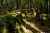
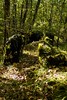
oldman visited on 7th Oct 2019 - their rating: Cond: 3 Amb: 5 Access: 3 Finding this allee couverte was not very easy. Our sat nav stopped us by a field telling us that the tomb was due South of our position. We crossed to the far edge of the field where the ground rose steeply through a wood. I climbed with some difficulty through the wood as there were no discernable paths and then saw the tumulus which contains the allee couvert above me. It is a wonderful place. very atmospheric. After taking photographs I followed a slight path along the ridge and found that the site could be approached from the East via a farm track and a path through the wood. I guess that permission should be sought if this is the desired approach as there are many properte privee notices as one leaves the farm track. They are probably there only to deter Cep hunters.
")
You may be viewing yesterday's version of this page. To see the most up to date information please register for a free account.
")
")
")
Do not use the above information on other web sites or publications without permission of the contributor.
Nearby Images from Flickr


The above images may not be of the site on this page, but were taken nearby. They are loaded from Flickr so please click on them for image credits.
Click here to see more info for this site
Nearby sites
Click here to view sites on an interactive map of the areaKey: Red: member's photo, Blue: 3rd party photo, Yellow: other image, Green: no photo - please go there and take one, Grey: site destroyed
Download sites to:
KML (Google Earth)
GPX (GPS waypoints)
CSV (Garmin/Navman)
CSV (Excel)
To unlock full downloads you need to sign up as a Contributory Member. Otherwise downloads are limited to 50 sites.
Turn off the page maps and other distractions
Nearby sites listing. In the following links * = Image available
568m ENE 66° Menhir de l'Eglise de Mourrens* Standing Stone (Menhir)
1.4km ESE 114° Menhir de Higaros* Standing Stone (Menhir)
7.7km WSW 257° Allée funéraire de Honrède* Passage Grave
8.0km WSW 255° Menhir de La Honrède* Standing Stone (Menhir)
16.3km WSW 255° Allée couverte du Passage de Serbat* Passage Grave
16.6km ESE 115° Dolmen As Peyrès Burial Chamber or Dolmen
17.6km ESE 119° Menhir Grand Peyro* Standing Stone (Menhir)
20.0km W 271° Allée couverte de Choisy n°2* Passage Grave
20.4km W 271° Pompiey allée couverte* Passage Grave
21.6km NE 38° Menhir de Lastournelles* Standing Stone (Menhir)
23.0km SSE 147° Sempesserre tumulus Chambered Tomb
23.6km NE 34° Tres Peyres de Ste Colombe de Villeneuve* Burial Chamber or Dolmen
23.8km WNW 284° Menhir de Roudes* Standing Stone (Menhir)
23.9km WNW 286° Allée Couverte de Cranté* Passage Grave
24.1km WNW 288° Allée couverte de Caubeyres* Passage Grave
24.1km WNW 288° La Pile de Caubeyres* Stone Circle
24.1km NE 42° Pierre branlante de Pujols* Natural Stone / Erratic / Other Natural Feature
26.1km NNE 26° Las Tres Peyres d'Allez-et-Cazeneuve* Burial Chamber or Dolmen
28.7km W 277° Lumé dolmen* Passage Grave
29.0km E 86° Menhir de la Croix-du-Diable* Standing Stone (Menhir)
29.2km WSW 252° Cromlech de las Naou-Peyros* Stone Circle
29.2km WSW 256° Allée couverte de Peyre Soule* Passage Grave
30.1km N 355° Menhir du Râle* Standing Stone (Menhir)
30.9km NE 52° Allées funéraires de Grézac* Passage Grave
31.2km NNE 29° Allée couverte des Anglais de Lédat* Burial Chamber or Dolmen
View more nearby sites and additional images


 We would like to know more about this location. Please feel free to add a brief description and any relevant information in your own language.
 Wir möchten mehr über diese Stätte erfahren. Bitte zögern Sie nicht, eine kurze Beschreibung und relevante Informationen in Deutsch hinzuzufügen.
 Nous aimerions en savoir encore un peu sur les lieux. S'il vous plaît n'hesitez pas à ajouter une courte description et tous les renseignements pertinents dans votre propre langue.
 Quisieramos informarnos un poco más de las lugares. No dude en añadir una breve descripción y otros datos relevantes en su propio idioma.