


<< Our Photo Pages >> St. Botolph's Well (Hadstock) - Holy Well or Sacred Spring in England in Essex
Submitted by DavidCWoods on Monday, 08 August 2005 Page Views: 7804
Springs and Holy WellsSite Name: St. Botolph's Well (Hadstock)Country: England
NOTE: This site is 4.014 km away from the location you searched for.
County: Essex Type: Holy Well or Sacred Spring
Nearest Town: Saffron Walden Nearest Village: Hadstock
Map Ref: TL55864478
Latitude: 52.079443N Longitude: 0.273032E
Condition:
| 5 | Perfect |
| 4 | Almost Perfect |
| 3 | Reasonable but with some damage |
| 2 | Ruined but still recognisable as an ancient site |
| 1 | Pretty much destroyed, possibly visible as crop marks |
| 0 | No data. |
| -1 | Completely destroyed |
| 5 | Superb |
| 4 | Good |
| 3 | Ordinary |
| 2 | Not Good |
| 1 | Awful |
| 0 | No data. |
| 5 | Can be driven to, probably with disabled access |
| 4 | Short walk on a footpath |
| 3 | Requiring a bit more of a walk |
| 2 | A long walk |
| 1 | In the middle of nowhere, a nightmare to find |
| 0 | No data. |
| 5 | co-ordinates taken by GPS or official recorded co-ordinates |
| 4 | co-ordinates scaled from a detailed map |
| 3 | co-ordinates scaled from a bad map |
| 2 | co-ordinates of the nearest village |
| 1 | co-ordinates of the nearest town |
| 0 | no data |
Internal Links:
External Links:
I have visited· I would like to visit
willowman1 visited on 14th Aug 2017 - their rating: Cond: 3 Amb: 3 Access: 4
 (PID:16136)")
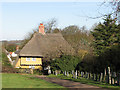
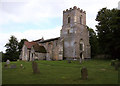
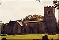
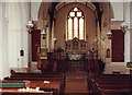
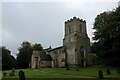
Hadstock is a placed deeply steeped in history. The church is dedicated to St. Botolph, an East Anglian abbot of the seventh century. St. Botolph’s Church is situated up a small hill from the centre of the village, and excavations there over the years have revealed a large empty Saxon grave and signs of burning on the walls.
The well, also dedicated to St. Botolph, is sited just over the chuchyard wall to the south of the church – according to the guidebook, water from it was reputed to cure scrofula.
This well is also recorded as Pastscape Monument No. 374149, which quotes from a notice in the porch in the church: "St. Botolph's Well is in the churchyard under the old pump. It is one of the most ancient wells in the country and was until 1930 the main water supply of the entire village, and it never ran dry."
The Northern Antiquarian (TNA) also features a page for this holy well - see their entry for St. Botolph’s Well, Hadstock, Essex, which gives directions for finding this well, together with a photograph, descriptions from 19th, 20th and 21st century reference material plus local folklore. TNA curiously adds: "it was commonly believed that the spring water drains from the graveyard above it: and hence it has earned the name ‘bone gravy’. Despite all these traditions, this did not deter the locals, who vouched for its goodness. Even when piped water was brought to the village in the 1930s, many locals could not see the point as the well water was good enough."
You may be viewing yesterday's version of this page. To see the most up to date information please register for a free account.
 (PID:36134)")
 (PID:36133)")
 (PID:16138)")
 (PID:16137)")
Do not use the above information on other web sites or publications without permission of the contributor.
Nearby Images from Geograph Britain and Ireland:
©2011(licence)
©2011(licence)
©2013(licence)
©2013(licence)
©2023(licence)
The above images may not be of the site on this page, they are loaded from Geograph.
Please Submit an Image of this site or go out and take one for us!
Click here to see more info for this site
Nearby sites
Key: Red: member's photo, Blue: 3rd party photo, Yellow: other image, Green: no photo - please go there and take one, Grey: site destroyed
Download sites to:
KML (Google Earth)
GPX (GPS waypoints)
CSV (Garmin/Navman)
CSV (Excel)
To unlock full downloads you need to sign up as a Contributory Member. Otherwise downloads are limited to 50 sites.
Turn off the page maps and other distractions
Nearby sites listing. In the following links * = Image available
2.7km E 89° Bartlow Hills* Barrow Cemetery (TL586449)
3.6km SE 133° Lady Well (Ashdon) Holy Well or Sacred Spring (TL586424)
6.5km SSW 196° Saffron Walden* Turf Maze (TL543385)
6.5km SSW 200° Saffron Walden Museum* Museum (TL538386)
6.5km SSW 208° Saffron Walden Puddingstone* Natural Stone / Erratic / Other Natural Feature (TL530389)
7.9km SW 215° Ring Hill (Essex) Hillfort (TL515382)
8.2km WSW 251° Valance Farm Round Barrow(s) (TL4823241818)
9.2km NNW 330° Babraham* Long Barrow (TL510526)
9.3km SSW 207° Mutlow Hill Round Barrow(s) (TL5193236381)
9.6km NNW 331° Copley Hill* Round Barrow(s) (TL509530)
9.7km N 355° Mutlow Hill* Round Barrow(s) (TL5466354380)
10.1km NW 324° Wormwood Hill* Round Barrow(s) (TL497528)
10.6km E 83° Haverhill marker stone* Marker Stone (TL6633546395)
10.6km SSW 203° Leper Stone* Standing Stone (Menhir) (TL520349)
10.8km NW 325° Wandlebury* Hillfort (TL493534)
10.9km NW 324° Gog and Magog Giants Hill Figures* Hill Figure or Geoglyph (TL492534)
11.0km WNW 286° Chronicle Hills Barrow Cemetery (TL452475)
11.0km W 272° Thriplow Heath 1 Round Barrow(s) (TL4479044782)
11.1km W 275° Thriplow Ring Ditch Misc. Earthwork (TL44784537)
11.5km S 186° Debden Pudding Stone* Natural Stone / Erratic / Other Natural Feature (TL550333)
11.7km WNW 282° Thriplow Round Barrow(s) (TL4431646901)
11.9km SSW 200° Newport Puddingstone* Natural Stone / Erratic / Other Natural Feature (TL521335)
12.3km W 266° Thrplow Heath 2 Round Barrow(s) (TL4362943549)
12.3km SSW 204° Wicken Bonhunt Puddingstone* Natural Stone / Erratic / Other Natural Feature (TL511334)
12.5km WSW 245° Chrishall hoard Ancient Mine, Quarry or other Industry (TL4465339161)
View more nearby sites and additional images


 We would like to know more about this location. Please feel free to add a brief description and any relevant information in your own language.
 Wir möchten mehr über diese Stätte erfahren. Bitte zögern Sie nicht, eine kurze Beschreibung und relevante Informationen in Deutsch hinzuzufügen.
 Nous aimerions en savoir encore un peu sur les lieux. S'il vous plaît n'hesitez pas à ajouter une courte description et tous les renseignements pertinents dans votre propre langue.
 Quisieramos informarnos un poco más de las lugares. No dude en añadir una breve descripción y otros datos relevantes en su propio idioma.