 with our Megalithic Portal iPhone app")


<< Our Photo Pages >> Butts Lane Hollows - Misc. Earthwork in England in East Sussex
Submitted by jonm on Wednesday, 07 August 2019 Page Views: 698
Multi-periodSite Name: Butts Lane HollowsCountry: England
NOTE: This site is 0.928 km away from the location you searched for.
County: East Sussex Type: Misc. Earthwork
Nearest Town: Eastbourne
Map Ref: TQ58180212
Latitude: 50.797061N Longitude: 0.243158E
Condition:
| 5 | Perfect |
| 4 | Almost Perfect |
| 3 | Reasonable but with some damage |
| 2 | Ruined but still recognisable as an ancient site |
| 1 | Pretty much destroyed, possibly visible as crop marks |
| 0 | No data. |
| -1 | Completely destroyed |
| 5 | Superb |
| 4 | Good |
| 3 | Ordinary |
| 2 | Not Good |
| 1 | Awful |
| 0 | No data. |
| 5 | Can be driven to, probably with disabled access |
| 4 | Short walk on a footpath |
| 3 | Requiring a bit more of a walk |
| 2 | A long walk |
| 1 | In the middle of nowhere, a nightmare to find |
| 0 | No data. |
| 5 | co-ordinates taken by GPS or official recorded co-ordinates |
| 4 | co-ordinates scaled from a detailed map |
| 3 | co-ordinates scaled from a bad map |
| 2 | co-ordinates of the nearest village |
| 1 | co-ordinates of the nearest town |
| 0 | no data |
Internal Links:
External Links:
")
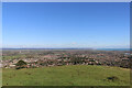
Hollows. Monument: "BUTTS LANE". There are two sets of monuments here. Both immediately east of Cold Crouch Tumulus and both located on the apex of the ridge. The location (see Pastscape Monument No. 972565) is quite approximate and is nearer the lower earthworks but describes the upper earthworks. The location I've given is at the lower earthworks.
The upper earthworks appear to be some form of track. The lower earthworks are described as hollows in Pastscape, but on site inspection are locally raised above the typical earth levels.
You may be viewing yesterday's version of this page. To see the most up to date information please register for a free account.
")
")
Do not use the above information on other web sites or publications without permission of the contributor.
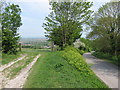
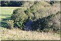
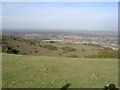
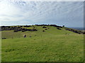
Nearby Images from Geograph Britain and Ireland:
©2011(licence)
©2021(licence)
©2007(licence)
©2017(licence)
©2021(licence)
The above images may not be of the site on this page, they are loaded from Geograph.
Please Submit an Image of this site or go out and take one for us!
Click here to see more info for this site
Nearby sites
Key: Red: member's photo, Blue: 3rd party photo, Yellow: other image, Green: no photo - please go there and take one, Grey: site destroyed
Download sites to:
KML (Google Earth)
GPX (GPS waypoints)
CSV (Garmin/Navman)
CSV (Excel)
To unlock full downloads you need to sign up as a Contributory Member. Otherwise downloads are limited to 50 sites.
Turn off the page maps and other distractions
Nearby sites listing. In the following links * = Image available
221m WSW 257° Cold Crouch Tumulus* Round Barrow(s) (TQ5796602062)
511m WNW 292° The Combe Tumuli* Barrow Cemetery (TQ577023)
620m S 180° Babylon Down Tumuli* Barrow Cemetery (TQ582015)
778m W 270° Combe Hill Enclosure* Causewayed Enclosure (TQ574021)
819m W 280° Combe West (Tumulus B)* Artificial Mound (TQ5736502230)
1.2km SSW 203° Borne Hill secondary tumulus* Round Barrow(s) (TQ57730098)
1.3km SSW 204° Bourne Hill Tumulus* Round Barrow(s) (TQ57700096)
1.4km S 189° Bourne to Foxholes Tumuli group* Artificial Mound (TQ58010070)
1.5km SSW 206° Bourne South West (Possible Tumulus)* Misc. Earthwork (TQ57580079)
1.5km WSW 239° Willingdon Bottom Field System Misc. Earthwork (TQ569013)
1.6km S 185° Fox Holes Tumuli* Barrow Cemetery (TQ58100052)
1.7km S 185° Foxholes-Beachy intermediate tumulus* Round Barrow(s) (TQ58090042)
1.7km SSW 209° Willingdon Hill Upper Tumuli Group* Artificial Mound (TQ57390058)
1.9km SSW 213° Willingdon Hill Tumuli* Barrow Cemetery (TQ57210050)
2.1km S 181° Foxholes-Beachy Brow Tumuli* Round Barrow(s) (TQ58210003)
2.4km S 179° Beachy Brow Tumulus* Round Barrow(s) (TV5830099690)
2.5km SW 221° Willingdon Hill Cross Dyke* Misc. Earthwork (TQ56600017)
2.5km WNW 287° Folkington Hill Round Barrow(s) (TQ55720279)
2.9km WNW 288° Hill Barn Tumuli* Barrow Cemetery (TQ55390293)
3.1km S 179° Crunden's Bottom Summit* Artificial Mound (TV58329907)
3.1km W 270° Holt Brow South Tumulus* Artificial Mound (TQ55090205)
3.1km WNW 283° Barrows West of Hill Barn* Artificial Mound (TQ55150273)
3.1km W 275° Holt Brow Tumulus* Round Barrow(s) (TQ5506802270)
3.2km ENE 72° Shinewater Park Ancient Trackway (TQ612032)
3.3km S 176° Eastbourne Downs Staging Tumuli Artificial Mound (TV5851698886)
View more nearby sites and additional images


 We would like to know more about this location. Please feel free to add a brief description and any relevant information in your own language.
 Wir möchten mehr über diese Stätte erfahren. Bitte zögern Sie nicht, eine kurze Beschreibung und relevante Informationen in Deutsch hinzuzufügen.
 Nous aimerions en savoir encore un peu sur les lieux. S'il vous plaît n'hesitez pas à ajouter une courte description et tous les renseignements pertinents dans votre propre langue.
 Quisieramos informarnos un poco más de las lugares. No dude en añadir una breve descripción y otros datos relevantes en su propio idioma.