


<< Our Photo Pages >> The Chiding stone - Natural Stone / Erratic / Other Natural Feature in England in Kent
Submitted by HOLYWELL on Monday, 18 February 2008 Page Views: 9108
Natural PlacesSite Name: The Chiding stoneCountry: England
NOTE: This site is 4.779 km away from the location you searched for.
County: Kent Type: Natural Stone / Erratic / Other Natural Feature
Nearest Village: Chiddingstone
Map Ref: TQ50064509
Latitude: 51.185347N Longitude: 0.145762E
Condition:
| 5 | Perfect |
| 4 | Almost Perfect |
| 3 | Reasonable but with some damage |
| 2 | Ruined but still recognisable as an ancient site |
| 1 | Pretty much destroyed, possibly visible as crop marks |
| 0 | No data. |
| -1 | Completely destroyed |
| 5 | Superb |
| 4 | Good |
| 3 | Ordinary |
| 2 | Not Good |
| 1 | Awful |
| 0 | No data. |
| 5 | Can be driven to, probably with disabled access |
| 4 | Short walk on a footpath |
| 3 | Requiring a bit more of a walk |
| 2 | A long walk |
| 1 | In the middle of nowhere, a nightmare to find |
| 0 | No data. |
| 5 | co-ordinates taken by GPS or official recorded co-ordinates |
| 4 | co-ordinates scaled from a detailed map |
| 3 | co-ordinates scaled from a bad map |
| 2 | co-ordinates of the nearest village |
| 1 | co-ordinates of the nearest town |
| 0 | no data |
Internal Links:
External Links:
I have visited· I would like to visit
beagle visited on 4th Dec 2022 - their rating: Cond: 3 Amb: 3 Access: 4
JohRvs visited on 6th Apr 2019 - their rating: Cond: 5 Amb: 4 Access: 4 Walked to from the road with Helen & Molly.
Average ratings for this site from all visit loggers: Condition: 4 Ambience: 3.5 Access: 4
")
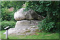
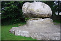
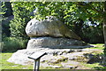
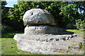
The name Chidda presumably being a local Saxon leader. Some have associated it with the Druids and others believe that the stone was used as a site of punishment mainly for local witches or wives, hence the name chide. It is an odd and atmospheric site and never appears to be overgrown. A personal story involves my father kissing it for good luck when my grandmother was ill. He returned 60 miles the next day to kick it when she unfortunately passed away that day!! Don't let that put you off!
You may be viewing yesterday's version of this page. To see the most up to date information please register for a free account.
Do not use the above information on other web sites or publications without permission of the contributor.
Nearby Images from Geograph Britain and Ireland:
©2014(licence)

©2014(licence)
©2014(licence)
©2015(licence)
©2015(licence)
The above images may not be of the site on this page, they are loaded from Geograph.
Please Submit an Image of this site or go out and take one for us!
Click here to see more info for this site
Nearby sites
Key: Red: member's photo, Blue: 3rd party photo, Yellow: other image, Green: no photo - please go there and take one, Grey: site destroyed
Download sites to:
KML (Google Earth)
GPX (GPS waypoints)
CSV (Garmin/Navman)
CSV (Excel)
To unlock full downloads you need to sign up as a Contributory Member. Otherwise downloads are limited to 50 sites.
Turn off the page maps and other distractions
Nearby sites listing. In the following links * = Image available
2.7km S 184° Stonewall Park Rock Shelters Cave or Rock Shelter (TQ49974241)
7.6km WSW 245° Dry Hill Fort* Hillfort (TQ432417)
7.9km SSE 154° Harness Well Holy Well or Sacred Spring (TQ538381)
8.6km SE 135° Happy Valley Cave or Rock Shelter (TQ564392)
8.7km SE 131° Toad Rock* Natural Stone / Erratic / Other Natural Feature (TQ5681539560)
8.7km SE 131° Denny Bottom Rock Shelters Cave or Rock Shelter (TQ568395)
8.8km SE 143° Adam's Well* Holy Well or Sacred Spring (TQ55623820)
9.0km SE 140° High Rocks Rock Shelters* Cave or Rock Shelter (TQ56093842)
9.0km SE 141° High Rocks Settlement Ancient Village or Settlement (TQ559382)
9.1km SE 140° High Rocks Hillfort* Hillfort (TQ561383)
9.2km NW 323° Squerries Park Camp Hillfort (TQ44285222)
10.0km SE 126° Tunbridge Wells Museum Museum (TQ584395)
10.2km SE 130° Tunbridge Wells Chalybeate Spring* Holy Well or Sacred Spring (TQ58133883)
10.2km SE 130° Chalybeate Spring* Holy Well or Sacred Spring (TQ5815138798)
10.5km SE 125° Calverley Grounds Standing Stones (TQ588393)
10.7km E 99° Capel Castle Hill (Kent) Hillfort (TQ607438)
11.4km W 268° St. Margaret's Well (Lingfield)* Holy Well or Sacred Spring (TQ386444)
11.7km NNW 339° Holy Well (Westerham) Holy Well or Sacred Spring (TQ455559)
12.1km NNE 16° Saint John's Spring (Greatness) Holy Well or Sacred Spring (TQ531568)
12.1km NNE 20° Millpond Wood Barrow* Round Barrow(s) (TQ53815661)
12.3km SW 228° Blunds Hole Cave or Rock Shelter (TQ41103670)
12.5km SSW 193° Lone Oak Spring Holy Well or Sacred Spring (TQ475328)
12.6km WSW 238° East Grinstead Museum* Museum (TQ3960338031)
12.8km SSE 150° Eridge Old Park Caves and Spring Cave or Rock Shelter (TQ568342)
13.3km NE 53° Plaxtol Not Known (by us) (TQ605533)
View more nearby sites and additional images


 We would like to know more about this location. Please feel free to add a brief description and any relevant information in your own language.
 Wir möchten mehr über diese Stätte erfahren. Bitte zögern Sie nicht, eine kurze Beschreibung und relevante Informationen in Deutsch hinzuzufügen.
 Nous aimerions en savoir encore un peu sur les lieux. S'il vous plaît n'hesitez pas à ajouter une courte description et tous les renseignements pertinents dans votre propre langue.
 Quisieramos informarnos un poco más de las lugares. No dude en añadir una breve descripción y otros datos relevantes en su propio idioma.