 with our Megalithic Portal iPhone app")


<< Text Pages >> Giant's Hill II Long Barrow - Long Barrow in England in Lincolnshire
Submitted by coldrum on Thursday, 27 October 2011 Page Views: 3777
Neolithic and Bronze AgeSite Name: Giant's Hill II Long BarrowCountry: England
NOTE: This site is 4.397 km away from the location you searched for.
County: Lincolnshire Type: Long Barrow
Map Ref: TF42927088
Latitude: 53.215762N Longitude: 0.138931E
Condition:
| 5 | Perfect |
| 4 | Almost Perfect |
| 3 | Reasonable but with some damage |
| 2 | Ruined but still recognisable as an ancient site |
| 1 | Pretty much destroyed, possibly visible as crop marks |
| 0 | No data. |
| -1 | Completely destroyed |
| 5 | Superb |
| 4 | Good |
| 3 | Ordinary |
| 2 | Not Good |
| 1 | Awful |
| 0 | No data. |
| 5 | Can be driven to, probably with disabled access |
| 4 | Short walk on a footpath |
| 3 | Requiring a bit more of a walk |
| 2 | A long walk |
| 1 | In the middle of nowhere, a nightmare to find |
| 0 | No data. |
| 5 | co-ordinates taken by GPS or official recorded co-ordinates |
| 4 | co-ordinates scaled from a detailed map |
| 3 | co-ordinates scaled from a bad map |
| 2 | co-ordinates of the nearest village |
| 1 | co-ordinates of the nearest town |
| 0 | no data |
Internal Links:
External Links:
Long Barrow in Lincolnshire
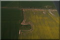
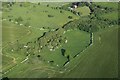
"Giant's Hill II Long Barrow Skendleby. The mound has been ploughed out and was only identifiable by geophysical survey prior to total excavation in the 1970's. The site is visible as a cropmark on aerial photographs taken in 2003."
Source: Pastscape.
You may be viewing yesterday's version of this page. To see the most up to date information please register for a free account.
Do not use the above information on other web sites or publications without permission of the contributor.
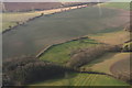
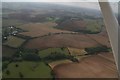
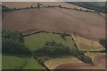
Nearby Images from Geograph Britain and Ireland:
©2018(licence)
©2014(licence)
©2018(licence)
©2018(licence)
©2023(licence)
The above images may not be of the site on this page, they are loaded from Geograph.
Please Submit an Image of this site or go out and take one for us!
Click here to see more info for this site
Nearby sites
Key: Red: member's photo, Blue: 3rd party photo, Yellow: other image, Green: no photo - please go there and take one, Grey: site destroyed
Download sites to:
KML (Google Earth)
GPX (GPS waypoints)
CSV (Garmin/Navman)
CSV (Excel)
To unlock full downloads you need to sign up as a Contributory Member. Otherwise downloads are limited to 50 sites.
Turn off the page maps and other distractions
Nearby sites listing. In the following links * = Image available
250m NNW 333° Giant's Hill Skendleby* Long Barrow (TF428711)
320m N 358° Giants' Hills Barrow Cemetery (TF429712)
1.3km WNW 295° Fordington Barrows Round Barrow(s) (TF417714)
1.9km NE 55° Deadmen's Graves* Long Barrow (TF444720)
3.1km WNW 298° Spellow Hills* Long Barrow (TF4014272239)
6.5km ENE 78° Butterbumps Barrow Cemetery* Barrow Cemetery (TF493724)
7.3km SW 223° Virgin's Well (Spilsby) Holy Well or Sacred Spring (TF381654)
8.0km WSW 237° Holy well (Mavis Enderby) Holy Well or Sacred Spring (TF363663)
8.8km NW 321° Beacon Plantation Long Barrow* Long Barrow (TF372776)
12.5km W 270° Newell Spring* Holy Well or Sacred Spring (TF3041770472)
15.3km NW 322° Bully Hills* Barrow Cemetery (TF33128272)
15.6km SW 235° Revesby Barrows* Round Barrow(s) (TF3029361632)
17.5km W 274° West Ashby Henge (TF25347168)
17.6km NW 312° Tathwell Long Barrow* Long Barrow (TF29458225)
21.0km W 279° Baumber Cursus* Cursus (TF22067350)
25.1km WNW 303° Burgh Top* Round Barrow(s) (TF21458406)
25.3km NW 311° Grims Mound* Round Barrow(s) (TF23258693)
25.8km NW 305° Burgh on Bain* Long Barrow (TF21298497)
32.4km NW 321° Hoe Hill Long Barrow* Long Barrow (TF215953)
33.3km NW 312° Bully Hill (Tealby)* Round Barrow(s) (TF17279227)
33.5km NW 321° Ash Hill Long Barrow* Long Barrow (TF20889612)
34.0km NW 314° Lud well (Stainton-Le-Vale)* Holy Well or Sacred Spring (TF17629376)
35.8km WNW 292° Wickenby Ancient Village or Settlement (TF0928883432)
36.1km NW 308° Walesby All Saints church carvings* Sculptured Stone (TF1382892388)
37.4km WSW 239° Anwick Drake Stones* Natural Stone / Erratic / Other Natural Feature (TF114506)
View more nearby sites and additional images


 We would like to know more about this location. Please feel free to add a brief description and any relevant information in your own language.
 Wir möchten mehr über diese Stätte erfahren. Bitte zögern Sie nicht, eine kurze Beschreibung und relevante Informationen in Deutsch hinzuzufügen.
 Nous aimerions en savoir encore un peu sur les lieux. S'il vous plaît n'hesitez pas à ajouter une courte description et tous les renseignements pertinents dans votre propre langue.
 Quisieramos informarnos un poco más de las lugares. No dude en añadir una breve descripción y otros datos relevantes en su propio idioma.