

<< Our Photo Pages >> La Motte a Dognon - Burial Chamber or Dolmen in France in Poitou:Charente (16)
Submitted by taupin on Saturday, 07 January 2012 Page Views: 3138
Neolithic and Bronze AgeSite Name: La Motte a DognonCountry: France
NOTE: This site is 5.154 km away from the location you searched for.
Département: Poitou:Charente (16) Type: Burial Chamber or Dolmen
Nearest Town: Angouleme Nearest Village: Cressac-Saint-Genis
Latitude: 45.455090N Longitude: 0.017420E
Condition:
| 5 | Perfect |
| 4 | Almost Perfect |
| 3 | Reasonable but with some damage |
| 2 | Ruined but still recognisable as an ancient site |
| 1 | Pretty much destroyed, possibly visible as crop marks |
| 0 | No data. |
| -1 | Completely destroyed |
| 5 | Superb |
| 4 | Good |
| 3 | Ordinary |
| 2 | Not Good |
| 1 | Awful |
| 0 | No data. |
| 5 | Can be driven to, probably with disabled access |
| 4 | Short walk on a footpath |
| 3 | Requiring a bit more of a walk |
| 2 | A long walk |
| 1 | In the middle of nowhere, a nightmare to find |
| 0 | No data. |
| 5 | co-ordinates taken by GPS or official recorded co-ordinates |
| 4 | co-ordinates scaled from a detailed map |
| 3 | co-ordinates scaled from a bad map |
| 2 | co-ordinates of the nearest village |
| 1 | co-ordinates of the nearest town |
| 0 | no data |
Internal Links:
External Links:
I have visited· I would like to visit
SolarMegalith would like to visit
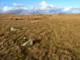
oldman visited on 19th Sep 2019 - their rating: Cond: 4 Amb: 4 Access: 4 An interesting tumulus. It is well covered by undergrowth and ivy so it is difficult to see its construction but there are a lot of loose stones around the edges that you can see so it may be that it is stone rather than an earth mound.
")
The dimensions are about 6 m on diametre and 2,5 m high; this mound is in a cropfield and covered by trees and ivy with no visible trace of dig.
On the nearest village "Le Temple" there is a templar church with listed fresco who tell the story of Crusaders in Jérusalem .
You may be viewing yesterday's version of this page. To see the most up to date information please register for a free account.
")
")
")
")
Do not use the above information on other web sites or publications without permission of the contributor.
Nearby Images from Flickr


The above images may not be of the site on this page, but were taken nearby. They are loaded from Flickr so please click on them for image credits.
Click here to see more info for this site
Nearby sites
Click here to view sites on an interactive map of the areaKey: Red: member's photo, Blue: 3rd party photo, Yellow: other image, Green: no photo - please go there and take one, Grey: site destroyed
Download sites to:
KML (Google Earth)
GPX (GPS waypoints)
CSV (Garmin/Navman)
CSV (Excel)
To unlock full downloads you need to sign up as a Contributory Member. Otherwise downloads are limited to 50 sites.
Turn off the page maps and other distractions
Nearby sites listing. In the following links * = Image available
11.5km N 3° Dolmen de la Boucharderie* Burial Chamber or Dolmen
11.7km NE 37° Tumulus de Malipougne* Burial Chamber or Dolmen
13.5km NE 35° La Chaire a Calvin* Cave or Rock Shelter
13.7km NE 51° Les Vachons (Voulgezac)* Cave or Rock Shelter
13.8km NE 51° Grotte des Rois Cave or Rock Shelter
17.0km W 268° Dolmen du Gros-Caillou Burial Chamber or Dolmen
19.8km E 92° Dolmen de Chez Vinaigre* Burial Chamber or Dolmen
20.5km WNW 297° Dolmen dit Gros-Caillou Burial Chamber or Dolmen
21.4km WSW 249° Dolmen de Baignes Sainte Radegonde* Burial Chamber or Dolmen
21.7km NNW 326° La Pierre Levée (Bouteville) Burial Chamber or Dolmen
22.1km ENE 76° Le Champignon* Natural Stone / Erratic / Other Natural Feature
22.3km ENE 75° La Quina* Cave or Rock Shelter
22.4km NE 54° Dolmen de Brande Burial Chamber or Dolmen
24.0km NW 325° Courades Dolmen* Burial Chamber or Dolmen
24.4km ENE 59° Dolmen de l'Etang Burial Chamber or Dolmen
24.4km NE 47° Dolmen de Pierre Levade Burial Chamber or Dolmen
24.9km SE 138° Abris de Badegoule Cave or Rock Shelter
26.4km E 82° Nécropole d'Edon Barrow Cemetery
27.0km ENE 78° Dolmen de Lambertie* Burial Chamber or Dolmen
27.2km E 80° Menhir de la Pierre Debout (Édon) Standing Stone (Menhir)
27.3km E 80° Dolmen de la Gélie* Burial Chamber or Dolmen
27.6km WNW 298° Saint Fort Dolmen* Burial Chamber or Dolmen
27.7km ENE 61° Le Roc De Sers* Cave or Rock Shelter
28.4km SW 221° Pierre Folle (Négrignac)* Burial Chamber or Dolmen
29.2km WNW 288° Tumulus du Cruchaud* Long Barrow
View more nearby sites and additional images


 We would like to know more about this location. Please feel free to add a brief description and any relevant information in your own language.
 Wir möchten mehr über diese Stätte erfahren. Bitte zögern Sie nicht, eine kurze Beschreibung und relevante Informationen in Deutsch hinzuzufügen.
 Nous aimerions en savoir encore un peu sur les lieux. S'il vous plaît n'hesitez pas à ajouter une courte description et tous les renseignements pertinents dans votre propre langue.
 Quisieramos informarnos un poco más de las lugares. No dude en añadir una breve descripción y otros datos relevantes en su propio idioma.