


<< Our Photo Pages >> La Cobata - Sculptured Stone in Mexico in Veracruz
Submitted by SolarMegalith on Friday, 15 April 2011 Page Views: 7068
Multi-periodSite Name: La CobataCountry: Mexico
NOTE: This site is 11.305 km away from the location you searched for.
Region: Veracruz Type: Sculptured Stone
Nearest Town: Santiago Tuxtla
Latitude: 18.465290N Longitude: 95.30252W
Condition:
| 5 | Perfect |
| 4 | Almost Perfect |
| 3 | Reasonable but with some damage |
| 2 | Ruined but still recognisable as an ancient site |
| 1 | Pretty much destroyed, possibly visible as crop marks |
| 0 | No data. |
| -1 | Completely destroyed |
| 5 | Superb |
| 4 | Good |
| 3 | Ordinary |
| 2 | Not Good |
| 1 | Awful |
| 0 | No data. |
| 5 | Can be driven to, probably with disabled access |
| 4 | Short walk on a footpath |
| 3 | Requiring a bit more of a walk |
| 2 | A long walk |
| 1 | In the middle of nowhere, a nightmare to find |
| 0 | No data. |
| 5 | co-ordinates taken by GPS or official recorded co-ordinates |
| 4 | co-ordinates scaled from a detailed map |
| 3 | co-ordinates scaled from a bad map |
| 2 | co-ordinates of the nearest village |
| 1 | co-ordinates of the nearest town |
| 0 | no data |
Internal Links:
External Links:
I have visited· I would like to visit
SolarMegalith visited on 1st Mar 2004 - their rating: Cond: 5 Amb: 3 Access: 5
")
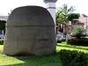
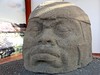
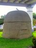
The Olmec head called La Cobata is located in the centre of Santiago Tuxtla. It was discovered in 1970 near Tres Zapotes, close to Rancho La Cobata. It is about 1 m high and has 165 tons of weight. It is unique among the Olmec sculptures because of its closed eyes.
You may be viewing yesterday's version of this page. To see the most up to date information please register for a free account.
Do not use the above information on other web sites or publications without permission of the contributor.
Nearby Images from Flickr
The above images may not be of the site on this page, but were taken nearby. They are loaded from Flickr so please click on them for image credits.
Click here to see more info for this site
Nearby sites
Click here to view sites on an interactive map of the areaKey: Red: member's photo, Blue: 3rd party photo, Yellow: other image, Green: no photo - please go there and take one, Grey: site destroyed
Download sites to:
KML (Google Earth)
GPX (GPS waypoints)
CSV (Garmin/Navman)
CSV (Excel)
To unlock full downloads you need to sign up as a Contributory Member. Otherwise downloads are limited to 50 sites.
Turn off the page maps and other distractions
Nearby sites listing. In the following links * = Image available
14.2km W 276° Tres Zapotes* Ancient Village or Settlement
83.1km SE 130° Cascajal Artificial Mound
97.9km SE 144° San Lorenzo Tenochtitlán Museum* Museum
103.0km SSE 147° El Azuzul* Pyramid / Mastaba
114.6km NW 314° Isla de Sacrificios* Ancient Temple
132.9km NW 312° Zempoala* Ancient Village or Settlement
139.2km ESE 107° La Venta.* Ancient Village or Settlement
177.7km NW 319° Quiahuiztlan* Rock Cut Tomb
204.4km SSW 213° Mitla* Ancient Village or Settlement
207.0km SW 216° Yagul* Ancient Village or Settlement
208.5km SW 217° Lambityeco* Ancient Village or Settlement
209.5km NW 305° Museo de Antropologia de Xalapa* Museum
209.9km SW 219° Dainzu* Ancient Village or Settlement
215.5km W 270° Ndachjian-Tehuacán* Ancient Village or Settlement
219.8km SW 226° Atzompa* Ancient Village or Settlement
221.5km SW 225° Monte Alban* Ancient Village or Settlement
222.6km E 95° Comalcalco* Ancient Village or Settlement
230.2km SW 220° El Palenque Ancient Village or Settlement
252.1km ESE 102° Museo Regional de Antropologia Carlos Pellier* Museum
255.2km W 274° Teteles de Santo Nombre* Ancient Village or Settlement
255.4km ESE 101° Parque Museo La Venta* Sculptured Stone
270.1km WSW 243° Tayata Ancient Village or Settlement
300.9km ESE 106° El Tortuguero* Ancient Village or Settlement
308.1km SSW 195° Copalita Eco-Archaeological Park Museum
309.7km NW 316° El Tajin* Ancient Village or Settlement
View more nearby sites and additional images


 We would like to know more about this location. Please feel free to add a brief description and any relevant information in your own language.
 Wir möchten mehr über diese Stätte erfahren. Bitte zögern Sie nicht, eine kurze Beschreibung und relevante Informationen in Deutsch hinzuzufügen.
 Nous aimerions en savoir encore un peu sur les lieux. S'il vous plaît n'hesitez pas à ajouter une courte description et tous les renseignements pertinents dans votre propre langue.
 Quisieramos informarnos un poco más de las lugares. No dude en añadir una breve descripción y otros datos relevantes en su propio idioma.