


<< Our Photo Pages >> Na Seacht dTeampaill - Early Christian Sculptured Stone in Ireland (Republic of) in Co. Galway
Submitted by jwells0612 on Thursday, 07 May 2020 Page Views: 1703
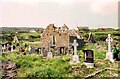
Early Medieval (Dark Age)Site Name: Na Seacht dTeampaill Alternative Name: The Seven ChurchesCountry: Ireland (Republic of) County: Co. Galway Type: Early Christian Sculptured Stone
Nearest Village: Eoghanacht
Latitude: 53.145900N Longitude: 9.7775W
Condition:
| 5 | Perfect |
| 4 | Almost Perfect |
| 3 | Reasonable but with some damage |
| 2 | Ruined but still recognisable as an ancient site |
| 1 | Pretty much destroyed, possibly visible as crop marks |
| 0 | No data. |
| -1 | Completely destroyed |
| 5 | Superb |
| 4 | Good |
| 3 | Ordinary |
| 2 | Not Good |
| 1 | Awful |
| 0 | No data. |
| 5 | Can be driven to, probably with disabled access |
| 4 | Short walk on a footpath |
| 3 | Requiring a bit more of a walk |
| 2 | A long walk |
| 1 | In the middle of nowhere, a nightmare to find |
| 0 | No data. |
| 5 | co-ordinates taken by GPS or official recorded co-ordinates |
| 4 | co-ordinates scaled from a detailed map |
| 3 | co-ordinates scaled from a bad map |
| 2 | co-ordinates of the nearest village |
| 1 | co-ordinates of the nearest town |
| 0 | no data |
Internal Links:
External Links:
I have visited· I would like to visit
jeffrep visited on 30th Jun 2002 - their rating: Cond: 3 Amb: 5 Access: 4 Second visit on April 22, 2008 on my second visit to Inishmore, Aran Islands. It is, indeed as jwells0612 says, a beautiful place to visit.
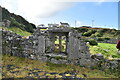
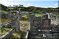
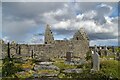
Situated near the village of Eoghanacht in the western part of Inishmore, this site consists, despite the name, of two churches -- Teampall Bhreacain (begun in the 8th Century) and Teampall an Phoill (from the 15th Century) -- as the other buildings are the dwellings of the monks. Teampall Bhreacain is the largest building and the main church on the site. Nearby is the burial place, marked by a fragment of stone, of St. Breacan. St. Breacan came to the Aran Islands in the late 5th-early 6th Century, around the same time as St. Enda.
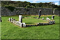
A number of other gravestones are found at the site. Four inscribed stone pillars, the oldest on the site, stand out marking a number of graves behind them. Also, there are the remains of two high crosses, one in the monastic grounds and the other in a nearby field.
")
Na Seacht dTeampaill is a beautiful place to visit, surrounded by the stapled green hills and oceanside views of the Aran Islands. It certainly gives you the feeling of solitude that was sought after by those paying a visit in the old times. The remainders of the churches are standing and are a very good experience to stop by and enjoy during your time in Inishmore.
You may be viewing yesterday's version of this page. To see the most up to date information please register for a free account.
")
")
")
Do not use the above information on other web sites or publications without permission of the contributor.
Nearby Images from Geograph Britain and Ireland:
©2021(licence)
©2021(licence)
©2021(licence)
©2021(licence)
©2021(licence)
The above images may not be of the site on this page, they are loaded from Geograph.
Please Submit an Image of this site or go out and take one for us!
Click here to see more info for this site
Nearby sites
Click here to view sites on an interactive map of the areaKey: Red: member's photo, Blue: 3rd party photo, Yellow: other image, Green: no photo - please go there and take one, Grey: site destroyed
Download sites to:
KML (Google Earth)
GPX (GPS waypoints)
CSV (Garmin/Navman)
CSV (Excel)
To unlock full downloads you need to sign up as a Contributory Member. Otherwise downloads are limited to 50 sites.
Turn off the page maps and other distractions
Nearby sites listing. In the following links * = Image available
64m NNE 28° High Cross (Teampall Bhreacain)* Ancient Cross
647m S 171° Dun Eoghanachta* Stone Fort or Dun (L812114)
878m SW 220° Clochan Chambered Cairn
1.3km ESE 113° Clochan na Carraige* Ancient Village or Settlement (L823115)
2.1km SE 140° Ogham stone at Kilmurvy* Standing Stone (Menhir) (L8241410412)
2.3km SSE 164° Dun Aengus* Stone Fort or Dun (L817098)
2.3km SE 138° Dún Aengus Inishmore Island Promontory Fort / Cliff Castle
4.4km ESE 118° Oghil Wedge Tomb* Wedge Tomb (L84980988)
5.5km ESE 112° Dún Eochla wedge tomb* Wedge Tomb (L8620409853)
5.6km ESE 112° Dun Eochla* Stone Fort or Dun (L863098)
6.4km ESE 104° Chiaráin stones* Holed Stone
7.5km SE 128° Dun Ducathair* Stone Fort or Dun (L870073)
14.7km ESE 118° Dún Chonchúir* Stone Fort or Dun
16.8km NE 41° Oorid Standing Stones (L924245)
19.6km ESE 118° O'Brien stone fort Stone Fort or Dun
19.6km N 357° Lough Scannaimh* Crannog
29.0km ESE 116° Teergonean* Court Tomb (R068985)
32.0km SE 132° St. Brigid's Holy Well* Holy Well or Sacred Spring (R044900)
32.7km E 95° Fanmore Midden* Ancient Village or Settlement
34.9km E 89° Caherdoonerish Ring Fort* Stone Fort or Dun
37.6km E 100° Derrynavaha* Wedge Tomb (M181048)
37.9km ESE 112° Boghill Centre Modern Stone Circle etc
38.6km E 99° Faunarooska Wedge Tomb* Wedge Tomb
38.9km SE 131° Calluragh South* Burial Chamber or Dolmen (R101860)
40.0km N 3° Lough Inagh Crannog
View more nearby sites and additional images


 We would like to know more about this location. Please feel free to add a brief description and any relevant information in your own language.
 Wir möchten mehr über diese Stätte erfahren. Bitte zögern Sie nicht, eine kurze Beschreibung und relevante Informationen in Deutsch hinzuzufügen.
 Nous aimerions en savoir encore un peu sur les lieux. S'il vous plaît n'hesitez pas à ajouter une courte description et tous les renseignements pertinents dans votre propre langue.
 Quisieramos informarnos un poco más de las lugares. No dude en añadir una breve descripción y otros datos relevantes en su propio idioma.