

<< Text Pages >> Beale Middle - Stone Row / Alignment in Ireland (Republic of) in Co. Kerry
Submitted by Anonymous on Tuesday, 01 October 2002 Page Views: 4078
Neolithic and Bronze AgeSite Name: Beale MiddleCountry: Ireland (Republic of)
NOTE: This site is 10.206 km away from the location you searched for.
County: Co. Kerry Type: Stone Row / Alignment
Map Ref: Q885475
Discovery Map Number: D85
Latitude: 52.567778N Longitude: 9.645135W
Condition:
| 5 | Perfect |
| 4 | Almost Perfect |
| 3 | Reasonable but with some damage |
| 2 | Ruined but still recognisable as an ancient site |
| 1 | Pretty much destroyed, possibly visible as crop marks |
| 0 | No data. |
| -1 | Completely destroyed |
| 5 | Superb |
| 4 | Good |
| 3 | Ordinary |
| 2 | Not Good |
| 1 | Awful |
| 0 | No data. |
| 5 | Can be driven to, probably with disabled access |
| 4 | Short walk on a footpath |
| 3 | Requiring a bit more of a walk |
| 2 | A long walk |
| 1 | In the middle of nowhere, a nightmare to find |
| 0 | No data. |
| 5 | co-ordinates taken by GPS or official recorded co-ordinates |
| 4 | co-ordinates scaled from a detailed map |
| 3 | co-ordinates scaled from a bad map |
| 2 | co-ordinates of the nearest village |
| 1 | co-ordinates of the nearest town |
| 0 | no data |
Internal Links:
External Links:
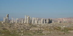
A Row of Six Stones (Alignment) in Co. Kerry, one of which has fallen
Have you visited this site? Please contribute a description or any thoughts by adding a comment.
You may be viewing yesterday's version of this page. To see the most up to date information please register for a free account.
Do not use the above information on other web sites or publications without permission of the contributor.
Nearby Images from Geograph Britain and Ireland:

©2015(licence)
©2005(licence)

©2015(licence)
©2005(licence)
The above images may not be of the site on this page, they are loaded from Geograph.
Please Submit an Image of this site or go out and take one for us!
Click here to see more info for this site
Nearby sites
Click here to view sites on an interactive map of the areaKey: Red: member's photo, Blue: 3rd party photo, Yellow: other image, Green: no photo - please go there and take one, Grey: site destroyed
Download sites to:
KML (Google Earth)
GPX (GPS waypoints)
CSV (Garmin/Navman)
CSV (Excel)
To unlock full downloads you need to sign up as a Contributory Member. Otherwise downloads are limited to 50 sites.
![]()
Turn off the page maps and other distractions
Nearby sites listing. In the following links * = Image available
12.2km N 351° St Chaoi's Holy Well (Kilkee)* Holy Well or Sacred Spring (Q868596)
29.9km SE 142° Feavautia Stone Row / Alignment
37.3km SW 224° Illauntannig Island Ancient Cross (Q621211)
38.8km SW 226° Illaunimnal Stone Circle (Q600210)
39.3km SE 132° Tooreenglanahee Stone Row / Alignment (R174207)
42.4km SSW 207° Ballygarret Stone Row / Alignment (Q685101)
42.7km SSW 204° Curraduff Stone Row* Stone Row / Alignment (Q703088)
42.9km SE 139° Cloghvoula* Stone Row / Alignment (R158143)
44.1km NNE 28° Calluragh South* Burial Chamber or Dolmen (R101860)
44.5km E 82° Tomdeely N Stone Row / Alignment (R329524)
44.9km SE 139° Knockaclarig* Stone Row / Alignment (R174130)
45.3km NNE 19° St. Brigid's Holy Well* Holy Well or Sacred Spring (R044900)
45.7km SSE 158° Scartaglin* Stone Circle (R05050479)
49.3km SSW 202° Caherpiece Standing Stone (Menhir)
50.4km SSE 157° Knockrower West Stone Row / Alignment
50.5km SW 223° Drom E Standing Stones (Q53181124)
50.9km SW 226° Cloonsherragh Stone Row / Alignment (Q511128)
51.1km SW 231° Meenanare Stone Circle (Q479162)
51.3km SSW 213° Dromvally SE* Standing Stones (Q59440514)
51.6km SSW 212° Derrygorman Standing Stones (Q599044)
52.8km SSW 214° Coumduff Standing Stones (Q58200418)
53.1km SW 221° Ballyhoneen Wedge Tomb* Wedge Tomb
53.4km SE 144° Glenreagh* Stone Circle (R189035)
53.9km SE 139° Knocknanagh E Stone Row / Alignment (R227057)
54.1km NNE 18° Teergonean* Court Tomb (R068985)
View more nearby sites and additional images


 We would like to know more about this location. Please feel free to add a brief description and any relevant information in your own language.
 Wir möchten mehr über diese Stätte erfahren. Bitte zögern Sie nicht, eine kurze Beschreibung und relevante Informationen in Deutsch hinzuzufügen.
 Nous aimerions en savoir encore un peu sur les lieux. S'il vous plaît n'hesitez pas à ajouter une courte description et tous les renseignements pertinents dans votre propre langue.
 Quisieramos informarnos un poco más de las lugares. No dude en añadir una breve descripción y otros datos relevantes en su propio idioma.