


<< Our Photo Pages >> Comillane - Stone Row / Alignment in Ireland (Republic of) in Co. Cork
Submitted by GaelicLaird on Tuesday, 11 April 2023 Page Views: 6966
Neolithic and Bronze AgeSite Name: ComillaneCountry: Ireland (Republic of)
NOTE: This site is 4.269 km away from the location you searched for.
County: Co. Cork Type: Stone Row / Alignment
Nearest Village: Comalán
Map Ref: V977229
Discovery Map Number: D88
Latitude: 51.450180N Longitude: 9.472306W
Condition:
| 5 | Perfect |
| 4 | Almost Perfect |
| 3 | Reasonable but with some damage |
| 2 | Ruined but still recognisable as an ancient site |
| 1 | Pretty much destroyed, possibly visible as crop marks |
| 0 | No data. |
| -1 | Completely destroyed |
| 5 | Superb |
| 4 | Good |
| 3 | Ordinary |
| 2 | Not Good |
| 1 | Awful |
| 0 | No data. |
| 5 | Can be driven to, probably with disabled access |
| 4 | Short walk on a footpath |
| 3 | Requiring a bit more of a walk |
| 2 | A long walk |
| 1 | In the middle of nowhere, a nightmare to find |
| 0 | No data. |
| 5 | co-ordinates taken by GPS or official recorded co-ordinates |
| 4 | co-ordinates scaled from a detailed map |
| 3 | co-ordinates scaled from a bad map |
| 2 | co-ordinates of the nearest village |
| 1 | co-ordinates of the nearest town |
| 0 | no data |
Internal Links:
External Links:
")
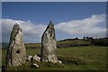
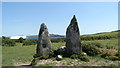
Two upright stones, aligned N-S, and one prostrate slab. N stone is 1.2m L, 0.4m T and 2.3m H, and is pierced by hole. S stone, 0.85m from last, is 1.15m L, 0.3m T and 2.65m H. Prostrate slab, concealed by field debris, lies 1.35m to the S and is 3.4m in maximum dimension. (O Nualláin 1988, 237. no. 56; Roberts 1988, Ch. 3, no. 5).
Site officially recorded as site CO153-012---- The above description is derived from the published 'Archaeological Inventory of County Cork. Volume 1: West Cork' (Dublin: Stationery Office, 1992).
You may be viewing yesterday's version of this page. To see the most up to date information please register for a free account.
")
")
Do not use the above information on other web sites or publications without permission of the contributor.
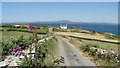
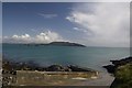
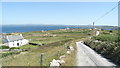
Nearby Images from Geograph Britain and Ireland:
©2018(licence)
©2011(licence)
©2018(licence)
©2011(licence)
©2018(licence)
The above images may not be of the site on this page, they are loaded from Geograph.
Please Submit an Image of this site or go out and take one for us!
Click here to see more info for this site
Nearby sites
Click here to view sites on an interactive map of the areaKey: Red: member's photo, Blue: 3rd party photo, Yellow: other image, Green: no photo - please go there and take one, Grey: site destroyed
Download sites to:
KML (Google Earth)
GPX (GPS waypoints)
CSV (Garmin/Navman)
CSV (Excel)
To unlock full downloads you need to sign up as a Contributory Member. Otherwise downloads are limited to 50 sites.
Turn off the page maps and other distractions
Nearby sites listing. In the following links * = Image available
922m SSW 209° Killickaforavane Passage Tomb* Passage Grave
1.8km SW 217° Crathach Thiar standing stone* Standing Stone (Menhir)
11.0km NNW 339° Rathcool Standing Stones (V93993325)
12.7km ENE 61° Lough Hyne St. Brigit's wells Holy Well or Sacred Spring
13.1km NE 34° Aghadown Standing Stone* Standing Stone (Menhir) (W0525533607)
13.4km NW 306° Arderawinny* Portal Tomb (V870310)
13.8km WNW 301° Altar Wedge Tomb* Wedge Tomb (V8592530224)
14.5km WNW 302° Toormore Wedge Tomb* Wedge Tomb (V855308)
14.5km NNE 20° Murrahin North* Stone Row / Alignment (W029365)
15.1km NNE 23° Lissaclarig West Stone Row / Alignment (W039367)
15.1km NNE 33° Foherlagh Standing Stones (W06173547)
15.2km NNE 23° Lissaclarig East Stone Row / Alignment (W04013670)
15.8km ENE 63° Drishanemore Wedge Tomb
16.3km NNE 14° Ballybane* Rock Art (W0183738669)
17.0km ENE 78° Toe Head Fort Promontory Fort / Cliff Castle
17.0km NNW 343° Coolcoulaghta* Standing Stones (V9310639301)
17.0km NNW 342° Dunbeacon* Stone Circle (V9270639202)
17.5km N 8° Derreennaclogh Rock Art* Rock Art
17.6km ENE 67° Lahardane Mor Wedge Tomb Wedge Tomb
17.8km ENE 70° Bawnishall Holy Well Holy Well or Sacred Spring
18.0km W 281° Castlemehigan cupmarked stone* Rock Art
18.6km ENE 77° Scullane Point Fort Promontory Fort / Cliff Castle
18.9km W 279° An Tuairín wedge tomb* Wedge Tomb
19.0km W 278° Arduslough wedge tomb* Wedge Tomb
19.0km W 277° Leenane wedge tomb* Wedge Tomb
View more nearby sites and additional images


 We would like to know more about this location. Please feel free to add a brief description and any relevant information in your own language.
 Wir möchten mehr über diese Stätte erfahren. Bitte zögern Sie nicht, eine kurze Beschreibung und relevante Informationen in Deutsch hinzuzufügen.
 Nous aimerions en savoir encore un peu sur les lieux. S'il vous plaît n'hesitez pas à ajouter une courte description et tous les renseignements pertinents dans votre propre langue.
 Quisieramos informarnos un poco más de las lugares. No dude en añadir una breve descripción y otros datos relevantes en su propio idioma.