

<< Our Photo Pages >> Ballyallaban Ring Fort - Stone Fort or Dun in Ireland (Republic of) in Co. Clare
Submitted by jeffrep on Thursday, 21 August 2008 Page Views: 10296
Multi-periodSite Name: Ballyallaban Ring Fort Alternative Name: An RathCountry: Ireland (Republic of)
NOTE: This site is 0.128 km away from the location you searched for.
County: Co. Clare Type: Stone Fort or Dun
Nearest Town: Ballyvaughan
Map Ref: M223050
Latitude: 53.090230N Longitude: 9.160466W
Condition:
| 5 | Perfect |
| 4 | Almost Perfect |
| 3 | Reasonable but with some damage |
| 2 | Ruined but still recognisable as an ancient site |
| 1 | Pretty much destroyed, possibly visible as crop marks |
| 0 | No data. |
| -1 | Completely destroyed |
| 5 | Superb |
| 4 | Good |
| 3 | Ordinary |
| 2 | Not Good |
| 1 | Awful |
| 0 | No data. |
| 5 | Can be driven to, probably with disabled access |
| 4 | Short walk on a footpath |
| 3 | Requiring a bit more of a walk |
| 2 | A long walk |
| 1 | In the middle of nowhere, a nightmare to find |
| 0 | No data. |
| 5 | co-ordinates taken by GPS or official recorded co-ordinates |
| 4 | co-ordinates scaled from a detailed map |
| 3 | co-ordinates scaled from a bad map |
| 2 | co-ordinates of the nearest village |
| 1 | co-ordinates of the nearest town |
| 0 | no data |
Internal Links:
External Links:
I have visited· I would like to visit
jeffrep visited on 18th Apr 2008 - their rating: Cond: 3 Amb: 4 Access: 4
optimistic20814 visited on 27th Jul 2002 - their rating: Cond: 3 Amb: 4 Access: 5 I've visited this many times. Right off the road near Ailwee Cave.
Average ratings for this site from all visit loggers: Condition: 3 Ambience: 4 Access: 4.5
")
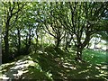
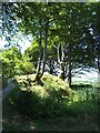
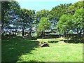
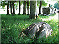
Ballyallaban Ring Fort is an earth fort, thus the name it is called on maps and by locals: An Rath. Surrounded by a fosse (a generally flooded moat or defensive ditch), the fort was built up and may have had a protective fence of sharp pointed stakes. While earth structures are the most common type of ancient monument in Ireland, they are rare in the rocky Burren area.
An Rath is in good repair and has a very well developed canopy of trees, mainly mature beech, with a deep trench all around which occasionally fills with water.
You may be viewing yesterday's version of this page. To see the most up to date information please register for a free account.
")
")
")
Do not use the above information on other web sites or publications without permission of the contributor.
Nearby Images from Geograph Britain and Ireland:
©2013(licence)
©2013(licence)
©2013(licence)

©2018(licence)
©2008(licence)
The above images may not be of the site on this page, they are loaded from Geograph.
Please Submit an Image of this site or go out and take one for us!
Click here to see more info for this site
Nearby sites
Click here to view sites on an interactive map of the areaKey: Red: member's photo, Blue: 3rd party photo, Yellow: other image, Green: no photo - please go there and take one, Grey: site destroyed
Download sites to:
KML (Google Earth)
GPX (GPS waypoints)
CSV (Garmin/Navman)
CSV (Excel)
To unlock full downloads you need to sign up as a Contributory Member. Otherwise downloads are limited to 50 sites.
Turn off the page maps and other distractions
Nearby sites listing. In the following links * = Image available
603m SSW 207° Cahermore Fort* Stone Fort or Dun
2.8km SSE 163° Gleninsheen 2* Wedge Tomb (M231023)
2.9km SSE 165° Gleninsheen 1* Wedge Tomb (M230022)
3.0km W 275° Faunarooska Wedge Tomb* Wedge Tomb
3.9km ESE 120° Boloona* Wedge Tomb (M257030)
4.1km S 190° Poulnabrucky* Wedge Tomb (M215010)
4.2km W 266° Derrynavaha* Wedge Tomb (M181048)
4.5km S 179° Baur North* Wedge Tomb (M223005)
4.7km SE 144° Ballymihil* Wedge Tomb (M250012)
4.8km SSE 164° Poulnabrone* Portal Tomb (M2359500356)
4.9km S 186° Baur South* Wedge Tomb (M217001)
5.0km S 185° Baur South Cairn* Cairn
5.3km SE 128° Poulaphuca* Wedge Tomb (M264017)
5.5km SSW 207° Cahermacnaughten Stone Fort or Dun (M197001)
5.6km SSE 166° Caherconnell* Stone Fort or Dun (R236995)
5.9km S 191° Lissylisheen* Wedge Tomb (R211992)
6.4km S 169° Poulawack Rath and Souterrain* Souterrain (Fogou, Earth House)
6.5km S 171° Poulawack Cairn* Cairn (R2323998520)
7.1km SSE 150° Meggagh* Wedge Tomb (R258988)
8.0km S 174° Iskancullin* Wedge Tomb (R230970)
9.0km NW 315° Caherdoonerish Ring Fort* Stone Fort or Dun
9.3km WNW 291° Fanmore Midden* Ancient Village or Settlement
9.4km ENE 75° Turlough Hill Neolithic fort* Hillfort (M31410732)
9.8km SE 136° Castletown Wedge Tomb* Wedge Tomb (R290978)
9.9km SE 136° Castletown Souterrain* Souterrain (Fogou, Earth House) (R291978)
View more nearby sites and additional images


 We would like to know more about this location. Please feel free to add a brief description and any relevant information in your own language.
 Wir möchten mehr über diese Stätte erfahren. Bitte zögern Sie nicht, eine kurze Beschreibung und relevante Informationen in Deutsch hinzuzufügen.
 Nous aimerions en savoir encore un peu sur les lieux. S'il vous plaît n'hesitez pas à ajouter une courte description et tous les renseignements pertinents dans votre propre langue.
 Quisieramos informarnos un poco más de las lugares. No dude en añadir una breve descripción y otros datos relevantes en su propio idioma.