


<< Our Photo Pages >> Mogador - Promontory Fort / Cliff Castle in Morocco
Submitted by C_Michael_Hogan on Friday, 02 November 2007 Page Views: 34498
Iron Age and Later PrehistorySite Name: Mogador Alternative Name: Arambys, SouiraCountry: Morocco Type: Promontory Fort / Cliff Castle
Nearest Town: Essaouira Nearest Village: Diabat
Latitude: 31.493731N Longitude: 9.78678W
Condition:
| 5 | Perfect |
| 4 | Almost Perfect |
| 3 | Reasonable but with some damage |
| 2 | Ruined but still recognisable as an ancient site |
| 1 | Pretty much destroyed, possibly visible as crop marks |
| 0 | No data. |
| -1 | Completely destroyed |
| 5 | Superb |
| 4 | Good |
| 3 | Ordinary |
| 2 | Not Good |
| 1 | Awful |
| 0 | No data. |
| 5 | Can be driven to, probably with disabled access |
| 4 | Short walk on a footpath |
| 3 | Requiring a bit more of a walk |
| 2 | A long walk |
| 1 | In the middle of nowhere, a nightmare to find |
| 0 | No data. |
| 5 | co-ordinates taken by GPS or official recorded co-ordinates |
| 4 | co-ordinates scaled from a detailed map |
| 3 | co-ordinates scaled from a bad map |
| 2 | co-ordinates of the nearest village |
| 1 | co-ordinates of the nearest town |
| 0 | no data |
Internal Links:
External Links:
I have visited· I would like to visit
C_Michael_Hogan has visited here
")
Mogador is an ancient Phoenician site on the west coast of Morocco, and is the most remote permanent settlement known with respect to the homeland in Tyre. Established in the 6th century BC according to A. Jodin, the original excavator on the island, (Moscati, 2001) the site falls within customary parameters for Phoenician site selection, lying near the outlet of a coastal estuary with a good natural harbour, and having good access to stone building material. Prior to arrival of the Phoenicians in this coastal area of Morocco, the indigenous peoples were generally interior peoples known even today as Berber tribes; (McGuiness, 2003) these nomads lived simply as early as 4000 BC and left little architectural trace; they were called ‘'Maures'‘ by the Romans leading to the region's early Roman name of Mauretania.
ETYMOLOGY. The original Phoenician name for this ancient outpost was ‘'Arambys'‘ deriving from the Phoenician phrase ‘'Har Anbin'‘, meaning ‘''mountain of grapes'‘ (Encyclopedia Phoenicia, 2007). Subsequently the site became known as Mogador, after the Phoenician word ‘'migdol'‘ for watchtower. The classical historian Herodotus refers to this site as Cerne and chronicles the early trading practises between the Phoenicians and the natives. {Herodotus, 425 BC) An alternative interpretation of the current name references some medieval charts which apply ‘'Amazigh'‘. A Berber word for ‘'safe anchorage'‘, (Encyclopedia Brittanica, 2007) although it seems likely this is simply a trailing designation from the Middle Ages using a word meaningful to those in charge in that era. The Moors applied the name ‘'Souira'‘ to Mogador, leading to the name of the present day city Essaouira.
HISTORY. Mogador was founded as the Phoenician merchant navy pushed through the Pillars of Hercules and began constructing a series of bases along the Atlantic coast starting with Lixus in the north, then Chellah (Hogan, 2007) and finally Mogador. Subsequent intermediate coastal colonies as well as the inland settlement of Volubilis were established over the next few centuries, although after the late 6th century these works were considered to be of Carthaginian origin, as the North African colony the Phoenicians established at Carthage undertook more independence in an era where Greek influence threatened the lengthy supply lines to the Phoenician homeland, and Persian armies harried the Phoenicians closer to their nerve center. Being secretive with regard to competitor seafaring nations, the Phoenicians kept these Atlantic routes privy, and even promulgated ideas with others that the Atlantic was a muddy quagmire of turbulent sea.
The Phoenicians initiated development of Mogador on the small island in the inlet bay of present day Essaouria. This island fit the Phoenician model well of providing a readily fortified place built upon a rocky promontory. Most of the early development took place at the southwestern end of the island at elevations of three to six metres. One of the first uses of this colony was the manufacture of a unique purple dye from a species of endemic murex shellfish; the dye was used in the coating of Getulian (named for a western Moroccan tribe of this area) purple ware. (Clark, 1975) Subsequently use of this dye spread to other parts of the ancient world including Rome as the basis of the purple colour used in noble robes. Clark further posits that the Phoenicians used Mogador as a base for inland mineral exploration.
A literary account by Carthaginian naval explorer Hanno chronicles most of the Phoenician/Carthaginian settlement of North Africa was chronicled in the Periplus of Hanno; (Hanno, 450 BC) this work notes the site of Mogador; Hanno's mission was part of a Carthaginian project for the marine circumnavigation of Africa. At some time when the Phoenician and Carthaginian holdings were under great pressure and at least by the 4th century BC, Mogador was abandoned for a considerable time to be resettled by Carhaginians in the 3rd century BC. After the Punic Wars conclusion, no further influence of Carthage was felt in Morocco and Mogador was left for whatever use the Romans might make. The principal noted re-use of Mogador was when King Juba, the Roman protegee, dispatched a contingent to re-open the dye production facility at Mogador in the early 1st century AD. That same naval force was subsequently sent on an exploration of the Canary Islands, using Mogador as their mission base.
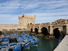
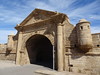
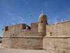
ARCHITECTURE. The core Phoenician structure is considered to be the fort situated at the southeast tip of the major islet of Ile Purpuraires, which islet lies approximately one kilometre northwest of the mouth of the Oued Ksob discharging onto the broad beach south of Essaouira. This fort would have provided a commanding position of the ancient harbour, and is positioned only about 100 metres south of Little Harbour on the islet itself. The Phoenicians were able to practise their classic form of stone construction by positioning the fort atop natural rocky formations approximately three to six metres high.
Perhaps a more interesting structure on the mainland beach itself is a large ruined watchtower fort named Bordj El Berod situated in the intertidal zone approximately 400 metres south of the Oued Ksob mouth. Strangely this structure does not seem to be associated with the islet fort in the sparse literature on Phoenician settlement here. I suggest this structure may have been an integral part of the Ile Purpuraires Phoenician settlement for the following reasons: (i) The position of Bordj El Berod is directly opposite the Phoenician fort at the southeast tip of Ile Purpuraires, permitting a pincer effect upon naval monitoring into the harbour via the southern approach; (Google, 2007) (ii) The bordj El Berod follows the classic form of Phoenician coastal construction using an immense natural rock as the foundation; (iii) The stonework follows Phoenician practises of mixing different stone types within the same structure. In particular most of the stonework utilises a native red stone hewn into large rectilinear blocks, but a prominent horizontal course is evident which uses a lighter gray colour hewn in smaller blocks and faced in a cylindrical fashion. (iv) The condition of the ruined Bordj is remarkable, given its exposure to surf and salty mist. The condition of mortar exposed to these elements is more suggestive of Phoenician engineering, whose talents regularly attacked severe coastal conditions, whereas later Moorish mortar was not as durable to these extreme marine conditions and indeed was not called upon for many such assignments. (v) The location of Bordj El Berod is remarkably consistent with a fort suitable for monitoring the trading practises that Heroditus depicts in describing the Phoenicians laying out their wares on a broad beach for local tribes to purchase; (vi) The destruction of the Bordj El Berod was most likely associated with the 18th century major earthquake in western Morocco, making it unlikely that any significant part of the Bordj was associated with the mainstream Moorish construction of Essaouira that occurred in the late 18th century and beyond; and (vii) The existence of such a grand mainland watchtower would clearly justify naming the site after the Phoenician word ‘'migdol'‘ or watchtower..
REFERENCES.
* Sabatino Moscati (2001) ‘'The Phoenicians'‘, I.B.Tauris, 670 pages ISBN 1850435332
* Justin McGuinness (2003) ‘'Footprint Morocco'‘, Footprint Travel Guides: Morocco, 560 pages
ISBN 190347163X
* Encyclopedia Phoeniciana: Phoenician Colonies
* Herodotus (c. 425 BC) "Histories", iv, 196
* Encyclopedia Brittanica (2007) "Mogador"
* C. Michael Hogan (2007) ‘'Chellah", The Megalithic Portal, ed. Andy Burnham, Surrey, England
* Desmond J. Clark, Roland Anthony Oliver, J. D. Fage, A. D. Roberts (1975) ‘'The Cambridge
History of Africa'‘, Cambridge University Press ISBN 0521215927
* Hanno (c. 450 BC) ‘'Periplus of Hanno'', Carthage
* Google Maps: Ile Purpuraires and Bordj El Berod, Morocco (2007)
The foregoing content is original work of C. Michael Hogan prepared for the Megalithic Portal
You may be viewing yesterday's version of this page. To see the most up to date information please register for a free account.
")
")
Do not use the above information on other web sites or publications without permission of the contributor.
Nearby Images from Flickr
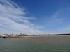
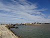
The above images may not be of the site on this page, but were taken nearby. They are loaded from Flickr so please click on them for image credits.
Click here to see more info for this site
Nearby sites
Click here to view sites on an interactive map of the areaKey: Red: member's photo, Blue: 3rd party photo, Yellow: other image, Green: no photo - please go there and take one, Grey: site destroyed
Download sites to:
KML (Google Earth)
GPX (GPS waypoints)
CSV (Garmin/Navman)
CSV (Excel)
To unlock full downloads you need to sign up as a Contributory Member. Otherwise downloads are limited to 50 sites.
Turn off the page maps and other distractions
Nearby sites listing. In the following links * = Image available
185.5km E 100° Oukaimeden* Rock Art
212.5km SSE 159° Tazca gravures rupestres* Rock Art
230.1km NNE 31° Akra Ancient Village or Settlement
241.0km NE 34° Karikon Teichos Ancient Village or Settlement
241.6km S 171° Boutrouch Rock Art Rock Art
270.0km SSE 168° Tamghilt N'zerzem* Rock Art
284.2km SSE 161° Foum el Hassane gravures rupestres Rock Art
284.9km SSE 147° Oum el Alek Gravures rupestres Rock Art
393.3km NE 44° Chellah* Ancient Village or Settlement
404.3km ESE 102° Ait Ouazik Menhir* Standing Stone (Menhir)
404.3km ESE 102° Ait Ouazik Burial Mounds* Barrow Cemetery
404.5km ESE 102° Ait Ouazik gravures rupestres* Rock Art
433.6km NE 53° Rock Shelter near Khemisset Cave or Rock Shelter
436.0km SW 234° Quesera de Bravo* Carving
437.2km SW 235° Taro Ye* Broch or Nuraghe
437.2km ESE 113° Tagounite barrow cemetery* Barrow Cemetery
438.7km SW 235° Taro del Volcan de La Corona* Ancient Village or Settlement
439.2km SW 235° Taro La Cerca (2)* Ancient Village or Settlement
439.3km SW 235° Taro La Cerca (1)* Cave or Rock Shelter
441.1km NE 43° Thamusida* Ancient Village or Settlement
446.9km SW 234° Montaña de Guinea Settlement* Ancient Village or Settlement
447.0km SW 234° Montaña de Guinea Outcrop* Rock Outcrop
447.0km SW 234° Las Veguetas de Guinea* Carving
447.2km SW 234° Vega Vieja* Carving
447.2km SW 234° Litófono Pena Luis* Natural Stone / Erratic / Other Natural Feature
View more nearby sites and additional images


 We would like to know more about this location. Please feel free to add a brief description and any relevant information in your own language.
 Wir möchten mehr über diese Stätte erfahren. Bitte zögern Sie nicht, eine kurze Beschreibung und relevante Informationen in Deutsch hinzuzufügen.
 Nous aimerions en savoir encore un peu sur les lieux. S'il vous plaît n'hesitez pas à ajouter une courte description et tous les renseignements pertinents dans votre propre langue.
 Quisieramos informarnos un poco más de las lugares. No dude en añadir una breve descripción y otros datos relevantes en su propio idioma.