


<< Our Photo Pages >> Cahercommaun - Hillfort in Ireland (Republic of) in Co. Clare
Submitted by Enkidu41 on Thursday, 03 June 2004 Page Views: 9631
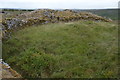
Iron Age and Later PrehistorySite Name: CahercommaunCountry: Ireland (Republic of) County: Co. Clare Type: Hillfort
Nearest Town: Kilfenora
Map Ref: R282965
Discovery Map Number: D51
Latitude: 53.014693N Longitude: 9.070528W
Condition:
| 5 | Perfect |
| 4 | Almost Perfect |
| 3 | Reasonable but with some damage |
| 2 | Ruined but still recognisable as an ancient site |
| 1 | Pretty much destroyed, possibly visible as crop marks |
| 0 | No data. |
| -1 | Completely destroyed |
| 5 | Superb |
| 4 | Good |
| 3 | Ordinary |
| 2 | Not Good |
| 1 | Awful |
| 0 | No data. |
| 5 | Can be driven to, probably with disabled access |
| 4 | Short walk on a footpath |
| 3 | Requiring a bit more of a walk |
| 2 | A long walk |
| 1 | In the middle of nowhere, a nightmare to find |
| 0 | No data. |
| 5 | co-ordinates taken by GPS or official recorded co-ordinates |
| 4 | co-ordinates scaled from a detailed map |
| 3 | co-ordinates scaled from a bad map |
| 2 | co-ordinates of the nearest village |
| 1 | co-ordinates of the nearest town |
| 0 | no data |
Internal Links:
External Links:
I have visited· I would like to visit
optimistic20814 has visited here
")
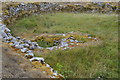
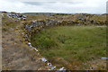
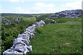
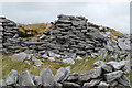
A triple-walled stone Fort dramatically situated on the edge of a cliff, all three of its concentric walls abutting the cliff edge. It was built around 800 AD. The outer wall measures 350 ft East-West by 245 ft North-South. The second rampart is 5' thick by about 4' high and around 30' from the inner caher. The enclosure had at least twelve stone buildings at varying times and a number of these had soutterrains
You may be viewing yesterday's version of this page. To see the most up to date information please register for a free account.
")
")
Do not use the above information on other web sites or publications without permission of the contributor.
Nearby Images from Geograph Britain and Ireland:
©2018(licence)
©2018(licence)
©2008(licence)
©2018(licence)
©2018(licence)
The above images may not be of the site on this page, they are loaded from Geograph.
Please Submit an Image of this site or go out and take one for us!
Click here to see more info for this site
Nearby sites
Click here to view sites on an interactive map of the areaKey: Red: member's photo, Blue: 3rd party photo, Yellow: other image, Green: no photo - please go there and take one, Grey: site destroyed
Download sites to:
KML (Google Earth)
GPX (GPS waypoints)
CSV (Garmin/Navman)
CSV (Excel)
To unlock full downloads you need to sign up as a Contributory Member. Otherwise downloads are limited to 50 sites.
Turn off the page maps and other distractions
Nearby sites listing. In the following links * = Image available
508m ENE 78° Tullycommon* Wedge Tomb (R287966)
1.1km SW 228° Creevagh* Wedge Tomb (R274958)
1.3km ENE 76° Slievenaglasha* Wedge Tomb (R295968)
1.5km NNE 31° Castletown Wedge Tomb* Wedge Tomb (R290978)
1.6km NE 34° Castletown Souterrain* Souterrain (Fogou, Earth House) (R291978)
2.8km ENE 62° Cappaghkennedy* Wedge Tomb (R307978)
2.8km SSW 207° Commons North 2* Wedge Tomb (R269940)
2.8km SSW 207° Commons North 1* Wedge Tomb (R269940)
3.3km NW 313° Meggagh* Wedge Tomb (R258988)
3.4km SSW 209° Parknabinnia* Wedge Tomb (R26489357)
3.6km SW 216° Parknabinnia Court Tomb* Court Tomb (R2602193585)
3.8km SSW 213° Parknabinnia 2* Wedge Tomb (R26069331)
3.9km SW 215° Parknabinnia Capstone Factory* Ancient Mine, Quarry or other Industry (R259933)
3.9km SW 218° Parknabinnia 1* Wedge Tomb (R25749341)
4.0km SW 215° Parknabinnia 4* Wedge Tomb (R25889326)
5.0km SSW 191° Killinaboy Church Early Christian Sculptured Stone (R27139158)
5.2km W 275° Iskancullin* Wedge Tomb (R230970)
5.2km WNW 294° Poulawack Rath and Souterrain* Souterrain (Fogou, Earth House)
5.3km WNW 291° Poulawack Cairn* Cairn (R2323998520)
5.5km WNW 302° Caherconnell* Stone Fort or Dun (R236995)
5.5km NNW 340° Poulaphuca* Wedge Tomb (M264017)
5.7km NW 325° Ballymihil* Wedge Tomb (M250012)
6.0km NW 309° Poulnabrone* Portal Tomb (M2359500356)
7.0km NNW 338° Boloona* Wedge Tomb (M257030)
7.1km WNW 303° Baur North* Wedge Tomb (M223005)
View more nearby sites and additional images


 We would like to know more about this location. Please feel free to add a brief description and any relevant information in your own language.
 Wir möchten mehr über diese Stätte erfahren. Bitte zögern Sie nicht, eine kurze Beschreibung und relevante Informationen in Deutsch hinzuzufügen.
 Nous aimerions en savoir encore un peu sur les lieux. S'il vous plaît n'hesitez pas à ajouter une courte description et tous les renseignements pertinents dans votre propre langue.
 Quisieramos informarnos un poco más de las lugares. No dude en añadir una breve descripción y otros datos relevantes en su propio idioma.