

<< Our Photo Pages >> Castletown Wedge Tomb - Wedge Tomb in Ireland (Republic of) in Co. Clare
Submitted by Enkidu41 on Thursday, 03 June 2004 Page Views: 5517
Neolithic and Bronze AgeSite Name: Castletown Wedge TombCountry: Ireland (Republic of)
NOTE: This site is 2.194 km away from the location you searched for.
County: Co. Clare Type: Wedge Tomb
Nearest Town: Kilfenora Nearest Village: Carran
Map Ref: R290978
Discovery Map Number: D51
Latitude: 53.026478N Longitude: 9.058897W
Condition:
| 5 | Perfect |
| 4 | Almost Perfect |
| 3 | Reasonable but with some damage |
| 2 | Ruined but still recognisable as an ancient site |
| 1 | Pretty much destroyed, possibly visible as crop marks |
| 0 | No data. |
| -1 | Completely destroyed |
| 5 | Superb |
| 4 | Good |
| 3 | Ordinary |
| 2 | Not Good |
| 1 | Awful |
| 0 | No data. |
| 5 | Can be driven to, probably with disabled access |
| 4 | Short walk on a footpath |
| 3 | Requiring a bit more of a walk |
| 2 | A long walk |
| 1 | In the middle of nowhere, a nightmare to find |
| 0 | No data. |
| 5 | co-ordinates taken by GPS or official recorded co-ordinates |
| 4 | co-ordinates scaled from a detailed map |
| 3 | co-ordinates scaled from a bad map |
| 2 | co-ordinates of the nearest village |
| 1 | co-ordinates of the nearest town |
| 0 | no data |
Internal Links:
External Links:
")
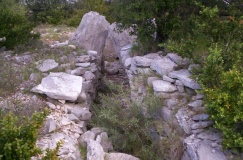
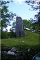
Reached from a farm track leading off a minor road near the village of Carran this tomb lies on the edge of a small escarpment near the top of a hill. It is in a ruinous condition with one side wall having completely collapsed into the chamber causing the opposite wall to break in two and to lean outwards quite badly. Part of the transverse end slab still stands. The capstone has slid off completely and lies flat on the ground next to the chamber.
You may be viewing yesterday's version of this page. To see the most up to date information please register for a free account.
Do not use the above information on other web sites or publications without permission of the contributor.
Nearby Images from Geograph Britain and Ireland:
©2011(licence)
©2020(licence)
©2018(licence)
©2006(licence)
©2008(licence)
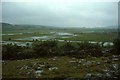
The above images may not be of the site on this page, they are loaded from Geograph.
Please Submit an Image of this site or go out and take one for us!
Click here to see more info for this site
Nearby sites
Click here to view sites on an interactive map of the areaKey: Red: member's photo, Blue: 3rd party photo, Yellow: other image, Green: no photo - please go there and take one, Grey: site destroyed
Download sites to:
KML (Google Earth)
GPX (GPS waypoints)
CSV (Garmin/Navman)
CSV (Excel)
To unlock full downloads you need to sign up as a Contributory Member. Otherwise downloads are limited to 50 sites.
Turn off the page maps and other distractions
Nearby sites listing. In the following links * = Image available
100m E 89° Castletown Souterrain* Souterrain (Fogou, Earth House) (R291978)
1.1km SSE 153° Slievenaglasha* Wedge Tomb (R295968)
1.2km SSW 193° Tullycommon* Wedge Tomb (R287966)
1.5km SSW 211° Cahercommaun* Hillfort (R282965)
1.7km E 89° Cappaghkennedy* Wedge Tomb (R307978)
2.6km SW 218° Creevagh* Wedge Tomb (R274958)
3.3km WNW 287° Meggagh* Wedge Tomb (R258988)
4.3km SSW 208° Commons North 1* Wedge Tomb (R269940)
4.3km SSW 208° Commons North 2* Wedge Tomb (R269940)
4.7km NW 326° Poulaphuca* Wedge Tomb (M264017)
4.9km SSW 210° Parknabinnia* Wedge Tomb (R26489357)
5.2km SW 214° Parknabinnia Court Tomb* Court Tomb (R2602193585)
5.2km NW 310° Ballymihil* Wedge Tomb (M250012)
5.4km SSW 212° Parknabinnia 2* Wedge Tomb (R26069331)
5.5km SSW 214° Parknabinnia Capstone Factory* Ancient Mine, Quarry or other Industry (R259933)
5.5km SW 216° Parknabinnia 1* Wedge Tomb (R25749341)
5.5km SSW 214° Parknabinnia 4* Wedge Tomb (R25889326)
5.6km W 278° Poulawack Rath and Souterrain* Souterrain (Fogou, Earth House)
5.6km WNW 287° Caherconnell* Stone Fort or Dun (R236995)
5.8km W 276° Poulawack Cairn* Cairn (R2323998520)
6.0km WNW 295° Poulnabrone* Portal Tomb (M2359500356)
6.0km W 262° Iskancullin* Wedge Tomb (R230970)
6.1km NNW 327° Boloona* Wedge Tomb (M257030)
6.5km SSW 196° Killinaboy Church Early Christian Sculptured Stone (R27139158)
7.2km WNW 291° Baur North* Wedge Tomb (M223005)
View more nearby sites and additional images


 We would like to know more about this location. Please feel free to add a brief description and any relevant information in your own language.
 Wir möchten mehr über diese Stätte erfahren. Bitte zögern Sie nicht, eine kurze Beschreibung und relevante Informationen in Deutsch hinzuzufügen.
 Nous aimerions en savoir encore un peu sur les lieux. S'il vous plaît n'hesitez pas à ajouter une courte description et tous les renseignements pertinents dans votre propre langue.
 Quisieramos informarnos un poco más de las lugares. No dude en añadir una breve descripción y otros datos relevantes en su propio idioma.